Poteau River near Panama
Critical Stages
29' - Action
29' - Flood
33' - Moderate
41' - Major
Latest Observation
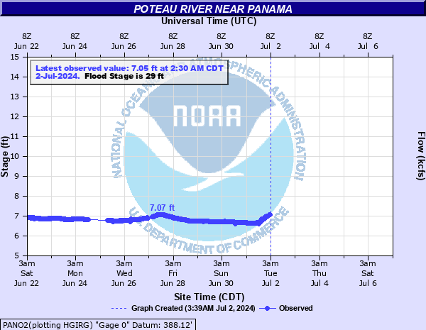
Updated: 9:30 PM CST 12/14/25
Status: No Flooding
Stage: 7.03 ft
Flow: 0.262 kcfs
Forecast
Forecast not available for this location.
| Time | Stage (ft) | Flow (kcfs) |
|---|---|---|
| 9:30 PM 12/14 | 7.03 | 0.262 |
| 9:15 PM 12/14 | 7.03 | 0.262 |
| 9:00 PM 12/14 | 7.04 | 0.264 |
| 8:45 PM 12/14 | 7.04 | 0.264 |
| 8:30 PM 12/14 | 7.03 | 0.262 |
| 8:15 PM 12/14 | 7.04 | 0.264 |
| 8:00 PM 12/14 | 7.04 | 0.264 |
| 7:45 PM 12/14 | 7.04 | 0.264 |
| 7:30 PM 12/14 | 7.04 | 0.264 |
| 7:15 PM 12/14 | 7.04 | 0.264 |
| 7:00 PM 12/14 | 7.04 | 0.264 |
| 6:45 PM 12/14 | 7.04 | 0.264 |
| 6:30 PM 12/14 | 7.04 | 0.264 |
| 6:15 PM 12/14 | 7.04 | 0.264 |
| 6:00 PM 12/14 | 7.04 | 0.264 |
| 5:45 PM 12/14 | 7.04 | 0.264 |
| 5:30 PM 12/14 | 7.05 | 0.266 |
| 5:15 PM 12/14 | 7.04 | 0.264 |
| 5:00 PM 12/14 | 7.05 | 0.266 |
| 4:45 PM 12/14 | 7.05 | 0.266 |
| 4:30 PM 12/14 | 7.05 | 0.266 |
| 4:15 PM 12/14 | 7.05 | 0.266 |
| 4:00 PM 12/14 | 7.05 | 0.266 |
| 3:45 PM 12/14 | 7.05 | 0.266 |
| 3:30 PM 12/14 | 7.05 | 0.266 |
| 3:15 PM 12/14 | 7.05 | 0.266 |
| 3:00 PM 12/14 | 7.06 | 0.268 |
| 2:45 PM 12/14 | 7.05 | 0.266 |
| 2:30 PM 12/14 | 7.06 | 0.268 |
| 2:15 PM 12/14 | 7.06 | 0.268 |
47' -
disasterous flooding occurs. Highway 271 may be impassible due to high water. Numerous county roads are totally impassable. A water treatment facility near Panama is surrounded by high water. This exceeds the flooding that occurred on May 3, 1990 when the river crested at 46.59 feet. This is an extremely dangerous and life threatening situation.
45' -
disasterous flooding occurs. Highway 271 is threatened by high water. Numerous county roads are totally impassable. A water treatment facility near Panama is surrounded by high water and water is over the burms of the retention ponds. This exceeds the flooding that occurred on May 12, 2015 when the river crested at 43.5 feet. This is an extremely dangerous and life threatening situation.
43' -
very severe agricultural flooding occurs. Numerous county roads are totally impassable. A water treatment facility near Panama is surrounded by high water and the retention ponds are flooded around 43.8 feet. This is similar to the flooding that occurred on May 12, 2015 when the river crested at 43.5 feet. This is an extremely dangerous and life threatening situation.
41' -
very severe flooding occurs from near Poteau to Arkoma. Up to 20,000 acres of farmland is flooded. Several county roads crossing the Poteau River are totally impassable. This is a dangerous and life threatening situation.
39' -
severe depths of flooding of crop and pasturelands occur from Shady Point to Arkoma. Several roads crossing the Poteau River are totally impassable.
37' -
extensive flooding of crop and pasturelands occur between Shady Point and Arkoma. Many roads in the floodplain become impassable.
35' -
moderate flooding of agricultural lands occur from Panama to Arkoma. Some local and county roads in the floodplain become impassable.
33' -
moderate flooding of agricultural lands occurs between Shady Point and Arkoma. Williams Road east of Panama and some local farm roads are flooded.
31' -
minor agricultural flooding occurs. Williams Road east of Panama is flooded.
29' -
minor agricultural flooding occurs.
| Date | Stage (ft) |
|---|---|
| Jun 18, 1935 | 49.6 |
| Dec 29, 2015 | 47.35 |
| May 3, 1990 | 46.59 |
| May 14, 1968 | 46.4 |
| Apr 17, 1939 | 45.1 |
| Dec 11, 1971 | 44.16 |
| May 12, 2015 | 43.54 |
| May 27, 2015 | 43.03 |
| Mar 20, 2008 | 42.84 |
| Mar 20, 2002 | 42.42 |
| Jan 6, 1998 | 41.4 |
| Sep 2, 2020 | 41.13 |
| Apr 24, 1973 | 40.9 |
| May 21, 1960 | 40.84 |
| Apr 9, 2002 | 40.63 |
| Apr 11, 2008 | 40.16 |
| Nov 26, 1996 | 39.6 |
| Apr 4, 1957 | 39.56 |
| Dec 1, 2006 | 39.45 |
| Mar 21, 1968 | 39.38 |
Data provided by the National Weather Service.