« Back to Air Force Academy Rivers
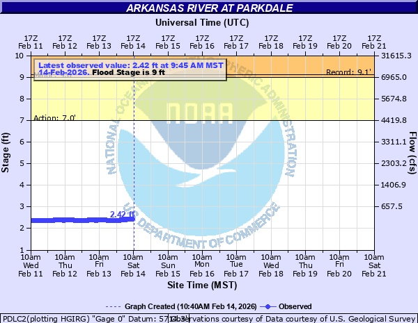
Arkansas River at Parkdale
Critical Stages
7' - Action
9' - Flood
10' - Moderate
11' - Major
Latest Observation
Updated: 6:45 PM MST 12/7/25
Status: No Flooding
Stage: 2.57 ft
Flow: 0.408 kcfs
Forecast
Forecast not available for this location.
| Time | Stage (ft) | Flow (kcfs) |
|---|---|---|
| 6:45 PM 12/7 | 2.57 | 0.408 |
| 6:30 PM 12/7 | 2.57 | 0.408 |
| 6:15 PM 12/7 | 2.57 | 0.408 |
| 6:00 PM 12/7 | 2.57 | 0.408 |
| 5:45 PM 12/7 | 2.57 | 0.408 |
| 5:30 PM 12/7 | 2.57 | 0.408 |
| 5:15 PM 12/7 | 2.57 | 0.408 |
| 5:00 PM 12/7 | 2.57 | 0.408 |
| 4:45 PM 12/7 | 2.58 | 0.413 |
| 4:30 PM 12/7 | 2.58 | 0.413 |
| 4:15 PM 12/7 | 2.57 | 0.408 |
| 4:00 PM 12/7 | 2.57 | 0.408 |
| 3:45 PM 12/7 | 2.57 | 0.408 |
| 3:30 PM 12/7 | 2.57 | 0.408 |
| 3:15 PM 12/7 | 2.57 | 0.408 |
| 3:00 PM 12/7 | 2.57 | 0.408 |
| 2:45 PM 12/7 | 2.57 | 0.408 |
| 2:30 PM 12/7 | 2.57 | 0.408 |
| 2:15 PM 12/7 | 2.57 | 0.408 |
| 2:00 PM 12/7 | 2.57 | 0.408 |
| 1:45 PM 12/7 | 2.57 | 0.408 |
| 1:30 PM 12/7 | 2.57 | 0.408 |
| 1:15 PM 12/7 | 2.57 | 0.408 |
| 1:00 PM 12/7 | 2.57 | 0.408 |
| 12:45 PM 12/7 | 2.57 | 0.408 |
| 12:30 PM 12/7 | 2.57 | 0.408 |
| 12:15 PM 12/7 | 2.57 | 0.408 |
| 12:00 PM 12/7 | 2.57 | 0.408 |
| 11:45 AM 12/7 | 2.57 | 0.408 |
| 11:30 AM 12/7 | 2.57 | 0.408 |
12' -
Water reaches the base of the bridge near Parkdale.
11.5' -
Significant flooding occurs in Canon City.
11' -
Water rises to the base of the bridge at Texas Creek.
10' -
Flood waters impact homes and businesses along the river between Cotopaxi and Texas Creek.
9.5' -
Water rises over railroad tracks in low spots along the river from Parkdale to Portland.
9' -
Minor agricultural flooding of fields and pastures along the river occurs.
8.5' -
Water threatens Five Points Campground near Spikebuck.
8' -
Water threatens low spots along Highway 50 east of Cotopaxi.
7' -
The river is bankfull.
| Date | Stage (ft) |
|---|---|
| Jun 9, 1985 | 9.13 |
| Jun 18, 1995 | 8.82 |
| Jun 18, 2015 | 8.74 |
| Jun 12, 1980 | 8.07 |
| Jun 26, 1983 | 8.06 |
| Jun 15, 2019 | 8.01 |
| Jun 10, 2024 | 7.91 |
| Jun 10, 1987 | 7.84 |
| Jun 6, 2010 | 7.82 |
| Jun 21, 1997 | 7.48 |
| Jun 14, 1996 | 7.25 |
| Jun 2, 2014 | 7.22 |
| Jun 20, 2017 | 7.12 |
| May 25, 1984 | 7.12 |
| Jun 20, 2008 | 6.98 |
| Jun 6, 2016 | 6.68 |
| Jul 1, 2011 | 6.66 |
| May 31, 2003 | 6.59 |
| Jun 24, 1999 | 6.51 |
Data provided by the National Weather Service.