« Back to Alafia River State Park Rivers
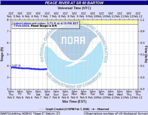
Peace River at SR 60 Bartow
Critical Stages
7.6' - Action
8' - Flood
9.2' - Moderate
10' - Major
Latest Observation
Updated: 12:15 AM EST 12/16/25
Status: No Flooding
Stage: 3.81 ft
Flow: 0.0475 kcfs
Forecast
Forecast not available for this location.
| Time | Stage (ft) | Flow (kcfs) |
|---|---|---|
| 12:15 AM 12/16 | 3.81 | 0.0475 |
| 12:00 AM 12/16 | 3.81 | 0.0475 |
| 11:45 PM 12/15 | 3.82 | 0.048 |
| 11:30 PM 12/15 | 3.82 | 0.048 |
| 11:15 PM 12/15 | 3.82 | 0.048 |
| 11:00 PM 12/15 | 3.82 | 0.048 |
| 10:45 PM 12/15 | 3.82 | 0.048 |
| 10:30 PM 12/15 | 3.83 | 0.0485 |
| 10:15 PM 12/15 | 3.83 | 0.0485 |
| 10:00 PM 12/15 | 3.83 | 0.0485 |
| 9:45 PM 12/15 | 3.84 | 0.049 |
| 9:30 PM 12/15 | 3.84 | 0.049 |
| 9:15 PM 12/15 | 3.84 | 0.049 |
| 9:00 PM 12/15 | 3.84 | 0.049 |
| 8:45 PM 12/15 | 3.84 | 0.049 |
| 8:30 PM 12/15 | 3.85 | 0.0495 |
| 8:15 PM 12/15 | 3.85 | 0.0495 |
| 8:00 PM 12/15 | 3.85 | 0.0495 |
| 7:45 PM 12/15 | 3.85 | 0.0495 |
| 7:30 PM 12/15 | 3.85 | 0.0495 |
| 7:15 PM 12/15 | 3.85 | 0.0495 |
| 7:00 PM 12/15 | 3.85 | 0.0495 |
| 6:45 PM 12/15 | 3.85 | 0.0495 |
| 6:30 PM 12/15 | 3.85 | 0.0495 |
| 6:15 PM 12/15 | 3.86 | 0.05 |
| 6:00 PM 12/15 | 3.86 | 0.05 |
| 5:45 PM 12/15 | 3.86 | 0.05 |
| 5:30 PM 12/15 | 3.86 | 0.05 |
| 5:15 PM 12/15 | 3.85 | 0.0495 |
| 5:00 PM 12/15 | 3.86 | 0.05 |
16' -
Water reaches the roadbed level of the bridge on State Road 60.
8' -
Private roads downstream flood.
| Date | Stage (ft) |
|---|---|
| Sep 12, 2004 | 11.13 |
| Sep 13, 1960 | 11.01 |
| Oct 2, 2022 | 10.8 |
| Jun 22, 1959 | 9.73 |
| Mar 20, 1960 | 9.72 |
| Sep 17, 2017 | 9.48 |
| Aug 2, 1960 | 9.16 |
| Mar 22, 1959 | 9.07 |
| Feb 23, 1998 | 9.03 |
| Oct 11, 1953 | 8.97 |
| Mar 24, 1998 | 8.85 |
| Oct 15, 2024 | 8.84 |
| Aug 12, 1995 | 8.83 |
| Sep 18, 1959 | 8.8 |
| Sep 30, 1994 | 8.75 |
| Jul 14, 1959 | 8.73 |
| Dec 18, 2002 | 8.7 |
| Oct 4, 1979 | 8.66 |
| Aug 17, 2019 | 8.64 |
| Sep 29, 1998 | 8.62 |
Data provided by the National Weather Service.