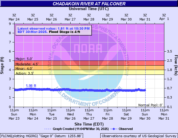
Chadakoin River at Falconer
Critical Stages
3.5' - Action
4' - Flood
4.5' - Moderate
5' - Major
Latest Observation
Updated: 10:30 AM EST 12/12/25
Status: No Flooding
Stage: 1.67 ft
Flow: 0.532 kcfs
Forecast
Forecast not available for this location.
| Time | Stage (ft) | Flow (kcfs) |
|---|---|---|
| 10:30 AM 12/12 | 1.67 | 0.532 |
| 10:15 AM 12/12 | 1.66 | 0.528 |
| 10:00 AM 12/12 | 1.66 | 0.528 |
| 9:45 AM 12/12 | 1.65 | 0.524 |
| 9:30 AM 12/12 | 1.67 | 0.532 |
| 9:15 AM 12/12 | 1.64 | 0.52 |
| 9:00 AM 12/12 | 1.67 | 0.532 |
| 8:45 AM 12/12 | 1.66 | 0.528 |
| 8:30 AM 12/12 | 1.63 | 0.517 |
| 8:15 AM 12/12 | 1.65 | 0.524 |
| 8:00 AM 12/12 | 1.66 | 0.528 |
| 7:45 AM 12/12 | 1.65 | 0.524 |
| 7:30 AM 12/12 | 1.67 | 0.532 |
| 7:15 AM 12/12 | 1.66 | 0.528 |
| 7:00 AM 12/12 | 1.67 | 0.532 |
| 6:45 AM 12/12 | 1.66 | 0.528 |
| 6:30 AM 12/12 | 1.65 | 0.524 |
| 6:15 AM 12/12 | 1.66 | 0.528 |
| 6:00 AM 12/12 | 1.66 | 0.528 |
| 5:45 AM 12/12 | 1.66 | 0.528 |
| 5:30 AM 12/12 | 1.66 | 0.528 |
| 5:15 AM 12/12 | 1.65 | 0.524 |
| 5:00 AM 12/12 | 1.65 | 0.524 |
| 4:45 AM 12/12 | 1.67 | 0.532 |
| 4:30 AM 12/12 | 1.67 | 0.532 |
| 4:15 AM 12/12 | 1.66 | 0.528 |
| 4:00 AM 12/12 | 1.67 | 0.532 |
| 3:45 AM 12/12 | 1.64 | 0.52 |
| 3:30 AM 12/12 | 1.66 | 0.528 |
| 3:15 AM 12/12 | 1.66 | 0.528 |
5' -
Major flood, widespread residential and commercial flooding along the river in Jamestown and Falconer.
4.5' -
Moderate flood, flooding of low lying areas close to the river in Jamestown and Falconer. Residential damages begin.
4' -
Flood stage, flooding and limited damages begin along the river near Dow Street.
3.5' -
Action stage, minor flooding to adjacent fields. Little or no damage.
| Date | Stage (ft) |
|---|---|
| Sep 14, 1979 | 4.93 |
| Jul 17, 2021 | 4.82 |
| Mar 5, 1976 | 4.67 |
| Apr 5, 1947 | 4.56 |
| Jul 20, 1986 | 4.48 |
| May 21, 2014 | 4.46 |
| Apr 1, 1936 | 4.41 |
| Sep 26, 1977 | 4.41 |
| Mar 18, 1942 | 4.35 |
| Jun 2, 1943 | 4.33 |
| Jul 16, 2021 | 4.18 |
| May 23, 2011 | 4.17 |
| Jan 12, 2017 | 4.17 |
| Mar 21, 1945 | 4.11 |
| Mar 8, 1956 | 4.1 |
| Apr 4, 1963 | 4.06 |
| Apr 25, 1961 | 4.02 |
| Jun 24, 1972 | 4.01 |
| Apr 11, 1940 | 3.91 |
| Feb 23, 1981 | 3.87 |
Data provided by the National Weather Service.