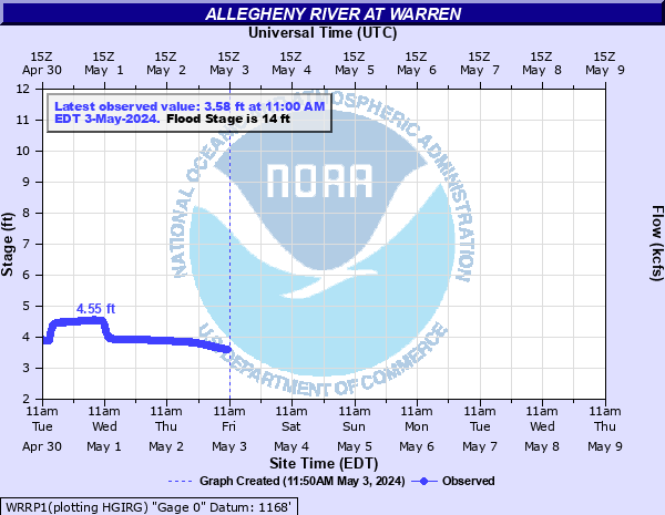
Allegheny River at Warren
Critical Stages
12' - Action
14' - Flood
15' - Moderate
17' - Major
Latest Observation
Updated: 11:00 AM EST 12/12/25
Status: No Flooding
Stage: 3.51 ft
Flow: 3.11 kcfs
Forecast
Forecast not available for this location.
| Time | Stage (ft) | Flow (kcfs) |
|---|---|---|
| 11:00 AM 12/12 | 3.51 | 3.11 |
| 10:45 AM 12/12 | 3.51 | 3.11 |
| 10:30 AM 12/12 | 3.5 | 3.09 |
| 10:15 AM 12/12 | 3.5 | 3.09 |
| 10:00 AM 12/12 | 3.5 | 3.09 |
| 9:45 AM 12/12 | 3.5 | 3.09 |
| 9:30 AM 12/12 | 3.49 | 3.06 |
| 9:15 AM 12/12 | 3.5 | 3.09 |
| 9:00 AM 12/12 | 3.49 | 3.06 |
| 8:45 AM 12/12 | 3.49 | 3.06 |
| 8:30 AM 12/12 | 3.48 | 3.04 |
| 8:15 AM 12/12 | 3.48 | 3.04 |
| 8:00 AM 12/12 | 3.48 | 3.04 |
| 7:45 AM 12/12 | 3.48 | 3.04 |
| 7:30 AM 12/12 | 3.48 | 3.04 |
| 7:15 AM 12/12 | 3.48 | 3.04 |
| 7:00 AM 12/12 | 3.48 | 3.04 |
| 6:45 AM 12/12 | 3.48 | 3.04 |
| 6:30 AM 12/12 | 3.48 | 3.04 |
| 6:15 AM 12/12 | 3.48 | 3.04 |
| 6:00 AM 12/12 | 3.48 | 3.04 |
| 5:45 AM 12/12 | 3.48 | 3.04 |
| 5:30 AM 12/12 | 3.48 | 3.04 |
| 5:15 AM 12/12 | 3.48 | 3.04 |
| 5:00 AM 12/12 | 3.48 | 3.04 |
| 4:45 AM 12/12 | 3.48 | 3.04 |
| 4:30 AM 12/12 | 3.49 | 3.06 |
| 4:15 AM 12/12 | 3.48 | 3.04 |
| 4:00 AM 12/12 | 3.49 | 3.06 |
| 3:45 AM 12/12 | 3.49 | 3.06 |
18' -
Many homes and businesses on both banks experience catastrophic flooding.
17' -
Many homes and businesses are affected by high water. The railroad tracks and business Route 6 are flooded. Water affects Warren General Hospital on the left bank.
15' -
A number of homes and businesses on the right, or north bank are affected by high water. Several streets are closed.
14' -
The right, or north bank begins to overflow, affecting a few houses and a couple of streets in low lying areas near the river.
| Date | Stage (ft) |
|---|---|
| Mar 17, 1865 | 19.4 |
| Mar 8, 1956 | 18.3 |
| Dec 12, 1873 | 17.7 |
| Mar 27, 1913 | 17.2 |
| Mar 22, 1948 | 17.1 |
| Apr 6, 1947 | 17 |
| Jan 22, 1959 | 16.5 |
| Mar 30, 1916 | 16 |
| Mar 28, 1936 | 15.9 |
| Mar 2, 1902 | 15.8 |
| Mar 13, 1920 | 15.8 |
| Mar 6, 1964 | 15 |
| May 25, 1961 | 14.9 |
| Mar 29, 1950 | 14.4 |
| Mar 10, 1964 | 14.2 |
| Mar 31, 1960 | 14 |
| Mar 27, 1963 | 14 |
| Feb 26, 1961 | 14 |
| Jun 24, 1972 | 11.5 |
Data provided by the National Weather Service.