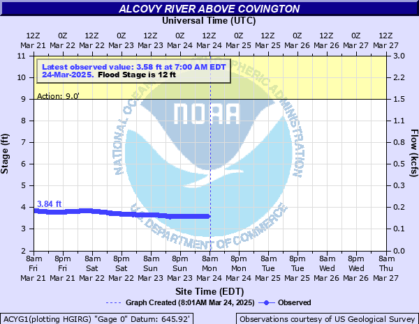
Alcovy River above Covington
Critical Stages
9' - Action
12' - Flood
16' - Moderate
20' - Major
Latest Observation
Updated: 12:00 AM EST 12/8/25
Status: No Flooding
Stage: 3.58 ft
Flow: 0.158 kcfs
Forecast
Forecast not available for this location.
| Time | Stage (ft) | Flow (kcfs) |
|---|---|---|
| 12:00 AM 12/8 | 3.58 | 0.158 |
| 11:45 PM 12/7 | 3.58 | 0.158 |
| 11:30 PM 12/7 | 3.59 | 0.159 |
| 11:15 PM 12/7 | 3.59 | 0.159 |
| 11:00 PM 12/7 | 3.59 | 0.159 |
| 10:45 PM 12/7 | 3.6 | 0.16 |
| 10:30 PM 12/7 | 3.6 | 0.16 |
| 10:15 PM 12/7 | 3.6 | 0.16 |
| 10:00 PM 12/7 | 3.61 | 0.161 |
| 9:45 PM 12/7 | 3.61 | 0.161 |
| 9:30 PM 12/7 | 3.62 | 0.162 |
| 9:15 PM 12/7 | 3.62 | 0.162 |
| 9:00 PM 12/7 | 3.63 | 0.163 |
| 8:45 PM 12/7 | 3.63 | 0.163 |
| 8:30 PM 12/7 | 3.64 | 0.164 |
| 8:15 PM 12/7 | 3.64 | 0.164 |
| 8:00 PM 12/7 | 3.65 | 0.165 |
| 7:45 PM 12/7 | 3.65 | 0.165 |
| 7:30 PM 12/7 | 3.65 | 0.165 |
| 7:15 PM 12/7 | 3.66 | 0.166 |
| 7:00 PM 12/7 | 3.66 | 0.166 |
| 6:45 PM 12/7 | 3.67 | 0.167 |
| 6:30 PM 12/7 | 3.67 | 0.167 |
| 6:15 PM 12/7 | 3.68 | 0.168 |
| 6:00 PM 12/7 | 3.68 | 0.168 |
| 5:45 PM 12/7 | 3.69 | 0.169 |
| 5:30 PM 12/7 | 3.69 | 0.169 |
| 5:15 PM 12/7 | 3.7 | 0.17 |
| 5:00 PM 12/7 | 3.7 | 0.17 |
| 4:45 PM 12/7 | 3.71 | 0.171 |
22' -
Major flooding with widespread innundation expands further into the woodlands and fields near the river upstream and downstream from the gage on Alcovy Trestle Road. The water level reaches the top of the bridge with erosion likely to the road on either side of the bridge. Portions of Hamby Lane and Alcovy Trestle Road will be under two feet of water. The bridge and roads will be closed by local officials.
20' -
Major flooding begins. Widespread innundation of water expands further into the woodlands and fields near the river upstream and downstream from the gage on Alcovy Trestle Road. The bridge forms an obstacle and acts like a dam causing some backwater and erosion eddies to the sides of the bridge. The intersection of Hamby Lane and Alcovy Trestle Road begins to flood. This may cause local officials to close it.
18' -
Moderate flooding continues to expand further into the woodlands and fields near the river upstream and downstream from the gage on Alcovy Trestle Road. The bridge forms an obstacle and acts like a dam causing some backwater and erosion eddies to the sides of the bridge. The intersection of Hamby Lane and Alcovy Trestle Road begins to flood. This may cause local officials to close it.
16' -
Moderate flooding begins. Flooding continues to expand further into the woodlands and fields near the river upstream and downstream from the gage on Alcovy Trestle Road. The water level is near the bottom of the bridge. This may cause local officials to close it due to possible erosion around the supports.
14' -
Minor flooding continues of the natural flood plain and expands further into the woodlands along the river upstream and downstream from the gage on Alcovy Trestle Road.
12' -
Flood Stage is reached. Minor flooding begins of woodlands and the natural flood plain of the river upstream and downstream from the gage on Alcovy Trestle Road.
9' -
Bankfull conditions are reached along the river upstream and downstream from the gage on Alcovy Trestle Road.
| Date | Stage (ft) |
|---|---|
| Mar 16, 1976 | 14.79 |
| Mar 18, 1990 | 14.4 |
| Oct 5, 1995 | 13.9 |
| Jul 2, 2003 | 13.73 |
| Apr 21, 2019 | 13.57 |
| Dec 26, 2015 | 13.34 |
| Jan 11, 2024 | 13.13 |
| Mar 9, 1998 | 13.1 |
| Feb 8, 2020 | 12.92 |
| Sep 28, 2024 | 12.51 |
| Dec 31, 2015 | 12.4 |
| Nov 12, 2009 | 12.16 |
Data provided by the National Weather Service.