Camas Creek (Eastern ID) at Camas
Critical Stages
8.8' - Action
9.2' - Flood
Moderate
Major
Latest Observation
Updated: 1:30 PM MST 12/15/25
Status: No Flooding
Stage: 2.56 ft
Flow: -999 kcfs
Forecast
Forecast not available for this location.
| Time | Stage (ft) | Flow (kcfs) |
|---|---|---|
| 1:30 PM 12/15 | 2.56 | -999 |
| 1:15 PM 12/15 | 2.56 | -999 |
| 1:00 PM 12/15 | 2.56 | -999 |
| 12:45 PM 12/15 | 2.56 | -999 |
| 12:30 PM 12/15 | 2.56 | -999 |
| 12:15 PM 12/15 | 2.56 | -999 |
| 12:00 PM 12/15 | 2.56 | -999 |
| 11:45 AM 12/15 | 2.56 | -999 |
| 11:30 AM 12/15 | 2.56 | -999 |
| 11:15 AM 12/15 | 2.56 | -999 |
| 11:00 AM 12/15 | 2.56 | -999 |
| 10:45 AM 12/15 | 2.56 | -999 |
| 10:30 AM 12/15 | 2.56 | -999 |
| 10:15 AM 12/15 | 2.56 | -999 |
| 10:00 AM 12/15 | 2.56 | -999 |
| 9:45 AM 12/15 | 2.56 | -999 |
| 9:30 AM 12/15 | 2.56 | -999 |
| 9:15 AM 12/15 | 2.56 | -999 |
| 9:00 AM 12/15 | 2.56 | -999 |
| 8:45 AM 12/15 | 2.56 | -999 |
| 8:30 AM 12/15 | 2.56 | -999 |
| 8:15 AM 12/15 | 2.56 | -999 |
| 8:00 AM 12/15 | 2.56 | -999 |
| 7:45 AM 12/15 | 2.56 | -999 |
| 7:30 AM 12/15 | 2.56 | -999 |
| 7:15 AM 12/15 | 2.56 | -999 |
| 7:00 AM 12/15 | 2.56 | -999 |
| 6:45 AM 12/15 | 2.56 | -999 |
| 6:30 AM 12/15 | 2.56 | -999 |
| 6:15 AM 12/15 | 2.56 | -999 |
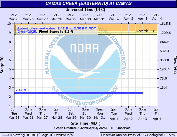
9.2' -
Possible flooding in many locations from Kilgore downstream through the Camas National Wildlife Refuge and into Mud Lake. Ponding in low-lying areas possible.
8.8' -
Near bankfull in many locations from Kilgore downstream through the Camas National Wildlife Refuge and into Mud Lake.
| Date | Stage (ft) |
|---|---|
| Mar 24, 2018 | 9.44 |
| Jun 8, 2011 | 9.06 |
| May 18, 2005 | 7.85 |
| May 16, 1984 | 7.61 |
| May 1, 2006 | 7.51 |
| May 16, 1998 | 7.49 |
| May 22, 1993 | 7.46 |
| May 14, 2017 | 7.35 |
| Apr 21, 2019 | 7.16 |
| May 12, 1995 | 6.91 |
| May 31, 1999 | 6.79 |
| May 4, 1982 | 6.62 |
| May 2, 1952 | 6.53 |
| Apr 14, 2016 | 6.48 |
| Apr 23, 2009 | 6.36 |
| May 9, 2008 | 6.36 |
| Apr 2, 2012 | 5.51 |
| Jun 15, 2022 | 5.18 |
| Apr 22, 2010 | 5.18 |
| Apr 13, 2013 | 4.4 |
Data provided by the National Weather Service.