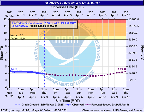
Henrys Fork near Rexburg
Critical Stages
9' - Action
9.5' - Flood
11.5' - Moderate
13' - Major
Latest Observation
Updated: 1:15 PM MST 12/15/25
Status: No Flooding
Stage: 3.93 ft
Flow: 1.44 kcfs
Forecast
| Time | Stage (ft) | Flow (kcfs) |
|---|---|---|
| 5 PM 12/15 | 3.91 | 1.43 |
| 11 PM 12/15 | 3.87 | 1.4 |
| 5 AM 12/16 | 3.83 | 1.37 |
| 11 AM 12/16 | 3.8 | 1.35 |
| 5 PM 12/16 | 3.76 | 1.33 |
| 11 PM 12/16 | 3.74 | 1.31 |
| 5 AM 12/17 | 3.71 | 1.29 |
| 11 AM 12/17 | 3.71 | 1.29 |
| 5 PM 12/17 | 3.72 | 1.3 |
| 11 PM 12/17 | 3.74 | 1.31 |
| 5 AM 12/18 | 3.79 | 1.35 |
| 11 AM 12/18 | 3.85 | 1.39 |
| 5 PM 12/18 | 3.91 | 1.43 |
| 11 PM 12/18 | 3.96 | 1.46 |
| 5 AM 12/19 | 4 | 1.48 |
| 11 AM 12/19 | 4.03 | 1.5 |
| 5 PM 12/19 | 4.04 | 1.51 |
| 11 PM 12/19 | 4.05 | 1.52 |
| 5 AM 12/20 | 4.04 | 1.51 |
| 11 AM 12/20 | 4.04 | 1.51 |
| 5 PM 12/20 | 4.05 | 1.52 |
| 11 PM 12/20 | 4.09 | 1.54 |
| 5 AM 12/21 | 4.14 | 1.58 |
| 11 AM 12/21 | 4.18 | 1.6 |
| 5 PM 12/21 | 4.2 | 1.62 |
| 11 PM 12/21 | 4.22 | 1.63 |
| 5 AM 12/22 | 4.23 | 1.64 |
| 11 AM 12/22 | 4.23 | 1.64 |
| 5 PM 12/22 | 4.23 | 1.64 |
| 11 PM 12/22 | 4.23 | 1.64 |
| 5 AM 12/23 | 4.23 | 1.64 |
| 11 AM 12/23 | 4.23 | 1.64 |
| 5 PM 12/23 | 4.24 | 1.64 |
| 11 PM 12/23 | 4.25 | 1.65 |
| 5 AM 12/24 | 4.25 | 1.65 |
| 11 AM 12/24 | 4.25 | 1.65 |
| 5 PM 12/24 | 4.26 | 1.66 |
| 11 PM 12/24 | 4.28 | 1.67 |
| 5 AM 12/25 | 4.31 | 1.69 |
| Time | Stage (ft) | Flow (kcfs) |
|---|---|---|
| 1:15 PM 12/15 | 3.93 | 1.44 |
| 1:00 PM 12/15 | 3.92 | 1.43 |
| 12:45 PM 12/15 | 3.92 | 1.43 |
| 12:30 PM 12/15 | 3.92 | 1.43 |
| 12:15 PM 12/15 | 3.93 | 1.44 |
| 12:00 PM 12/15 | 3.91 | 1.43 |
| 11:45 AM 12/15 | 3.93 | 1.44 |
| 11:30 AM 12/15 | 3.93 | 1.44 |
| 11:15 AM 12/15 | 3.92 | 1.43 |
| 11:00 AM 12/15 | 3.92 | 1.43 |
| 10:45 AM 12/15 | 3.92 | 1.43 |
| 10:30 AM 12/15 | 3.92 | 1.43 |
| 10:15 AM 12/15 | 3.92 | 1.43 |
| 10:00 AM 12/15 | 3.93 | 1.44 |
| 9:45 AM 12/15 | 3.91 | 1.43 |
| 9:30 AM 12/15 | 3.93 | 1.44 |
| 9:15 AM 12/15 | 3.94 | 1.45 |
| 9:00 AM 12/15 | 3.93 | 1.44 |
| 8:45 AM 12/15 | 3.93 | 1.44 |
| 8:30 AM 12/15 | 3.94 | 1.45 |
| 8:15 AM 12/15 | 3.94 | 1.45 |
| 8:00 AM 12/15 | 3.94 | 1.45 |
| 7:45 AM 12/15 | 3.94 | 1.45 |
| 7:30 AM 12/15 | 3.95 | 1.45 |
| 7:15 AM 12/15 | 3.94 | 1.45 |
| 7:00 AM 12/15 | 3.95 | 1.45 |
| 6:45 AM 12/15 | 3.95 | 1.45 |
| 6:30 AM 12/15 | 3.95 | 1.45 |
| 6:15 AM 12/15 | 3.95 | 1.45 |
| 6:00 AM 12/15 | 3.94 | 1.45 |
13' -
Major and extensive flooding of farmland and pastureland near the river especially on the east bank will occur. Flooding/overtopping of access roads near the river will cut off local access. Water may start to back up on the upstream side of the Idaho State Highway 33 bridge (over the Henrys Fork) with large amounts of woody debris distributed throughout the reach. An irrigation water pump at Beaver Dick Park will be submerged and the USGS gagehouse will become affected.
11.5' -
Moderate flooding of farmland and pastureland near the river and side channels/sloughs will occur with impacts to farm outbuildings near W 2700 S. Some low lying secondary and access roads near the river will have water over them.
9.5' -
Minor flooding of farmland near the river will occur between the confluence of the Snake River and upstream to near St. Anthony. Lower Beaver Dick Park is under water and some picnic shelters are inaccessible. Portions of Warm Slough Access will be under water.
| Date | Stage (ft) |
|---|---|
| May 17, 1984 | 12.05 |
| Jun 9, 2011 | 11.87 |
| Jun 9, 2010 | 11.3 |
| May 18, 1996 | 11.26 |
| Jun 12, 1997 | 11.21 |
| Jun 13, 1983 | 10.5 |
| May 22, 2008 | 10.43 |
| May 17, 1993 | 10.4 |
| May 29, 1970 | 10.3 |
| Jun 11, 1981 | 10.23 |
| Jun 5, 1975 | 10.22 |
| Jun 20, 1964 | 10.18 |
| May 26, 2018 | 10.15 |
| May 29, 1982 | 10.12 |
| May 24, 2006 | 10.1 |
| May 14, 1971 | 10.02 |
| May 12, 1989 | 10.02 |
| Jun 4, 1986 | 9.96 |
| May 5, 1985 | 9.95 |
| Jun 7, 1974 | 9.8 |
Data provided by the National Weather Service.