South Fork Teton River near Rexburg
Critical Stages
9.2' - Action
Flood
Moderate
Major
Latest Observation
Updated: 1:00 PM MST 12/15/25
Status: No Flooding
Stage: 5.4 ft
Flow: 0.184 kcfs
Forecast
Forecast not available for this location.
| Time | Stage (ft) | Flow (kcfs) |
|---|---|---|
| 1:00 PM 12/15 | 5.4 | 0.184 |
| 12:45 PM 12/15 | 5.41 | 0.186 |
| 12:30 PM 12/15 | 5.41 | 0.186 |
| 12:15 PM 12/15 | 5.41 | 0.186 |
| 12:00 PM 12/15 | 5.42 | 0.188 |
| 11:45 AM 12/15 | 5.42 | 0.188 |
| 11:30 AM 12/15 | 5.42 | 0.188 |
| 11:15 AM 12/15 | 5.42 | 0.188 |
| 11:00 AM 12/15 | 5.42 | 0.188 |
| 10:45 AM 12/15 | 5.42 | 0.188 |
| 10:30 AM 12/15 | 5.42 | 0.188 |
| 10:15 AM 12/15 | 5.43 | 0.191 |
| 10:00 AM 12/15 | 5.43 | 0.191 |
| 9:45 AM 12/15 | 5.43 | 0.191 |
| 9:30 AM 12/15 | 5.43 | 0.191 |
| 9:15 AM 12/15 | 5.43 | 0.191 |
| 9:00 AM 12/15 | 5.43 | 0.191 |
| 8:45 AM 12/15 | 5.43 | 0.191 |
| 8:30 AM 12/15 | 5.43 | 0.191 |
| 8:15 AM 12/15 | 5.43 | 0.191 |
| 8:00 AM 12/15 | 5.43 | 0.191 |
| 7:45 AM 12/15 | 5.43 | 0.191 |
| 7:30 AM 12/15 | 5.43 | 0.191 |
| 7:15 AM 12/15 | 5.43 | 0.191 |
| 7:00 AM 12/15 | 5.44 | 0.193 |
| 6:45 AM 12/15 | 5.44 | 0.193 |
| 6:30 AM 12/15 | 5.44 | 0.193 |
| 6:15 AM 12/15 | 5.44 | 0.193 |
| 6:00 AM 12/15 | 5.44 | 0.193 |
| 5:45 AM 12/15 | 5.44 | 0.193 |
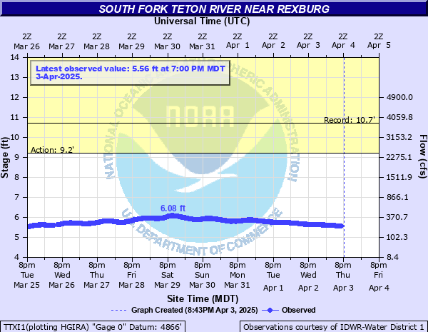
9.2' -
Low lying areas may experience ponding from near the city of Teton through Rexburg to the Snake River. South Fork of the Teton may be nearing bankfull in some locations. High flows may cause ponding near the Teton Lakes Golf Course.
| Date | Stage (ft) |
|---|---|
| Jun 11, 1997 | 10.68 |
| Jun 8, 2010 | 10.14 |
| May 18, 1996 | 10.06 |
| Jun 15, 2011 | 10.04 |
| May 22, 1993 | 9.69 |
| Jun 1, 1999 | 9.57 |
| May 25, 2018 | 8.96 |
| Jun 7, 1995 | 8.81 |
| May 21, 2006 | 8.74 |
| May 14, 2017 | 8.51 |
| May 22, 2008 | 8.51 |
| Jun 22, 2009 | 8.5 |
| Jun 1, 2020 | 8.43 |
| Jun 14, 2022 | 8.32 |
| Jun 9, 2019 | 8.22 |
| Jun 7, 1991 | 8.17 |
| May 1, 2014 | 7.97 |
| Jun 3, 2002 | 7.8 |
| May 24, 2021 | 7.69 |
| May 22, 2005 | 7.51 |
Data provided by the National Weather Service.