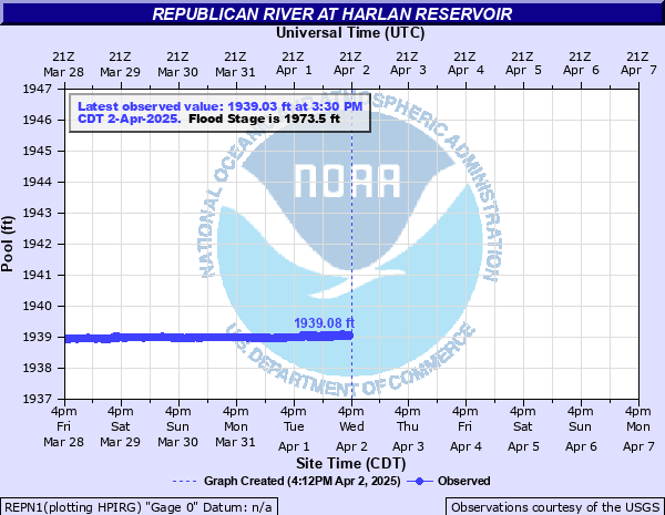
Republican River at Harlan Reservoir
Critical Stages
1955' - Action
1973.5' - Flood
Moderate
1977' - Major
Latest Observation
Updated: 4:30 AM CST 12/16/25
Status: No Flooding
Stage: 1934.9 ft
Flow: -999 kcfs
Forecast
Forecast not available for this location.
| Time | Stage (ft) | Flow (kcfs) |
|---|---|---|
| 4:30 AM 12/16 | 1934.9 | -999 |
| 4:15 AM 12/16 | 1934.9 | -999 |
| 4:00 AM 12/16 | 1934.89 | -999 |
| 3:45 AM 12/16 | 1934.89 | -999 |
| 3:30 AM 12/16 | 1934.9 | -999 |
| 3:15 AM 12/16 | 1934.89 | -999 |
| 3:00 AM 12/16 | 1934.88 | -999 |
| 2:45 AM 12/16 | 1934.89 | -999 |
| 2:30 AM 12/16 | 1934.91 | -999 |
| 2:15 AM 12/16 | 1934.91 | -999 |
| 2:00 AM 12/16 | 1934.89 | -999 |
| 1:45 AM 12/16 | 1934.89 | -999 |
| 1:30 AM 12/16 | 1934.9 | -999 |
| 1:15 AM 12/16 | 1934.9 | -999 |
| 1:00 AM 12/16 | 1934.89 | -999 |
| 12:45 AM 12/16 | 1934.89 | -999 |
| 12:30 AM 12/16 | 1934.89 | -999 |
| 12:15 AM 12/16 | 1934.89 | -999 |
| 12:00 AM 12/16 | 1934.88 | -999 |
| 11:45 PM 12/15 | 1934.89 | -999 |
| 11:30 PM 12/15 | 1934.89 | -999 |
| 11:15 PM 12/15 | 1934.9 | -999 |
| 11:00 PM 12/15 | 1934.89 | -999 |
| 10:45 PM 12/15 | 1934.88 | -999 |
| 10:30 PM 12/15 | 1934.88 | -999 |
| 10:15 PM 12/15 | 1934.89 | -999 |
| 10:00 PM 12/15 | 1934.89 | -999 |
| 9:45 PM 12/15 | 1934.88 | -999 |
| 9:30 PM 12/15 | 1934.89 | -999 |
| 9:15 PM 12/15 | 1934.88 | -999 |
1982' -
This elevation represents the height, or crest, of the dam.
1973.5' -
This elevation represents the top of the flood control pool.
1958' -
At this level Highway 183 could be damaged by wave action on the reservoir. The reservoir elevation record of 1958.2 was set on July 23, 2019.
1955' -
The lake level begins to threaten businesses in the Gremlin Cove area.
1945.73' -
This elevation represents the top of the irrigation pool.
1943.5' -
This elevation represents when water begins to flow over the spillway.
1932.5' -
This elevation represents the bottom of the irrigation pool.
| Date | Stage (ft) |
|---|---|
| Jul 23, 2019 | 1958.18 |
Data provided by the National Weather Service.