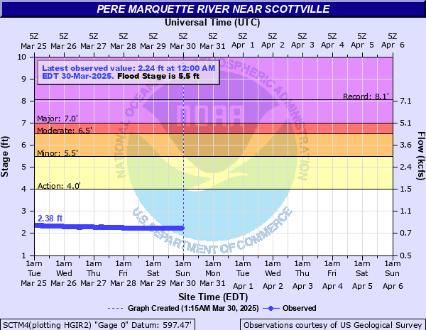
Pere Marquette River near Scottville
Critical Stages
4' - Action
5.5' - Flood
6.5' - Moderate
7' - Major
Latest Observation
Updated: 9:00 PM EST 12/14/25
Status: No Flooding
Stage: 2.88 ft
Flow: 1.01 kcfs
Forecast
Forecast not available for this location.
| Time | Stage (ft) | Flow (kcfs) |
|---|---|---|
| 10:00 PM 12/14 | 2.9 | 1.02 |
| 9:45 PM 12/14 | 2.9 | 1.02 |
| 9:30 PM 12/14 | 2.89 | 1.01 |
| 9:15 PM 12/14 | 2.89 | 1.01 |
| 9:00 PM 12/14 | 2.88 | 1.01 |
| 8:45 PM 12/14 | 2.88 | 1.01 |
| 8:30 PM 12/14 | 2.87 | 1 |
| 8:15 PM 12/14 | 2.87 | 1 |
| 8:00 PM 12/14 | 2.86 | 0.999 |
| 7:45 PM 12/14 | 2.85 | 0.995 |
| 7:30 PM 12/14 | 2.84 | 0.992 |
| 7:15 PM 12/14 | 2.84 | 0.992 |
| 7:00 PM 12/14 | 2.83 | 0.988 |
| 6:45 PM 12/14 | 2.81 | 0.98 |
| 6:30 PM 12/14 | 2.81 | 0.98 |
| 6:15 PM 12/14 | 2.8 | 0.976 |
| 6:00 PM 12/14 | 2.78 | 0.968 |
| 5:45 PM 12/14 | 2.77 | 0.965 |
| 5:30 PM 12/14 | 2.76 | 0.961 |
| 5:15 PM 12/14 | 2.75 | 0.957 |
| 5:00 PM 12/14 | 2.74 | 0.953 |
| 4:45 PM 12/14 | 2.73 | 0.949 |
| 4:30 PM 12/14 | 2.72 | 0.946 |
| 4:15 PM 12/14 | 2.71 | 0.942 |
| 4:00 PM 12/14 | 2.7 | 0.938 |
| 3:45 PM 12/14 | 2.69 | 0.934 |
| 3:30 PM 12/14 | 2.69 | 0.934 |
| 3:15 PM 12/14 | 2.68 | 0.931 |
| 3:00 PM 12/14 | 2.67 | 0.927 |
| 2:45 PM 12/14 | 2.67 | 0.927 |
9' -
High water reaches bottom girder of Scottville Road Bridge. Expect additional high water due to backwater from the bridge.
8' -
Expect major flooding of the campground in Scottville Park. High water covers Campground Road into park, the south side of Scottville Road near the bridge, Reek and Landon Roads upstream of Scottville.
5.5' -
Expect minor flooding of campgrounds located in Scottville Riverside Park.
5' -
Expect high water to begin covering Campground Road adjacent to river in Scottville Park.
4' -
River is bankfull. Overflow of low lying areas adjacent to the river occurs.
| Date | Stage (ft) |
|---|---|
| Sep 13, 1986 | 8.07 |
| Apr 16, 2014 | 6.83 |
| Mar 9, 1946 | 6.35 |
| Apr 17, 1974 | 6.26 |
| Jul 1, 1969 | 6.26 |
| Mar 7, 1976 | 6.18 |
| Dec 29, 2008 | 6.18 |
| Sep 4, 1975 | 6.16 |
| Apr 6, 1956 | 6 |
| Feb 22, 1994 | 5.95 |
| Mar 30, 1989 | 5.92 |
| Apr 4, 1959 | 5.84 |
| Jun 5, 1945 | 5.84 |
| Jun 13, 2008 | 5.81 |
| Mar 22, 1948 | 5.79 |
| Dec 11, 1966 | 5.79 |
| Apr 19, 1982 | 5.78 |
| Apr 2, 1979 | 5.75 |
| Mar 8, 2004 | 5.7 |
| Mar 29, 1963 | 5.64 |
Data provided by the National Weather Service.