Little Fork River at Littlefork
Critical Stages
20' - Action
22' - Flood
24' - Moderate
26' - Major
Latest Observation
Updated: 5:30 AM CST 12/16/25
Status: No Flooding
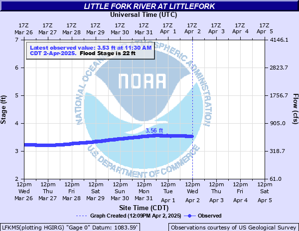
Stage: 2.75 ft
Flow: 0.21 kcfs
Forecast
Forecast not available for this location.
| Time | Stage (ft) | Flow (kcfs) |
|---|---|---|
| 6:30 AM 12/16 | 2.74 | 0.207 |
| 6:15 AM 12/16 | 2.75 | 0.21 |
| 6:00 AM 12/16 | 2.74 | 0.207 |
| 5:45 AM 12/16 | 2.74 | 0.207 |
| 5:30 AM 12/16 | 2.75 | 0.21 |
| 5:15 AM 12/16 | 2.74 | 0.207 |
| 5:00 AM 12/16 | 2.75 | 0.21 |
| 4:45 AM 12/16 | 2.75 | 0.21 |
| 4:30 AM 12/16 | 2.75 | 0.21 |
| 4:15 AM 12/16 | 2.75 | 0.21 |
| 4:00 AM 12/16 | 2.75 | 0.21 |
| 3:45 AM 12/16 | 2.75 | 0.21 |
| 3:30 AM 12/16 | 2.75 | 0.21 |
| 3:15 AM 12/16 | 2.75 | 0.21 |
| 3:00 AM 12/16 | 2.75 | 0.21 |
| 2:45 AM 12/16 | 2.75 | 0.21 |
| 2:30 AM 12/16 | 2.75 | 0.21 |
| 2:15 AM 12/16 | 2.75 | 0.21 |
| 2:00 AM 12/16 | 2.75 | 0.21 |
| 1:45 AM 12/16 | 2.75 | 0.21 |
| 1:30 AM 12/16 | 2.76 | 0.214 |
| 1:15 AM 12/16 | 2.76 | 0.214 |
| 1:00 AM 12/16 | 2.75 | 0.21 |
| 12:45 AM 12/16 | 2.76 | 0.214 |
| 12:30 AM 12/16 | 2.75 | 0.21 |
| 12:15 AM 12/16 | 2.76 | 0.214 |
| 12:00 AM 12/16 | 2.75 | 0.21 |
| 11:45 PM 12/15 | 2.76 | 0.214 |
| 11:30 PM 12/15 | 2.76 | 0.214 |
| 11:15 PM 12/15 | 2.76 | 0.214 |
24' -
Several homes threatened on the east bank of the Little Fork at the confluence with the Rainy River. This flooding is due to backwater and is dependant on both the height of the Little Fork and Rainy Rivers.
22' -
Several DNR boat landings and primative campgrounds adjacent to the river are inundated.
| Date | Stage (ft) |
|---|---|
| Apr 18, 1916 | 37 |
| May 11, 1950 | 37 |
| Apr 17, 1969 | 32.61 |
| Apr 25, 1979 | 32.59 |
| May 8, 1938 | 31.63 |
| Jun 14, 1970 | 31.08 |
| Apr 18, 1948 | 30.56 |
| Apr 4, 1975 | 30.33 |
| Apr 19, 1954 | 30.3 |
| Apr 21, 1972 | 30.05 |
| Apr 24, 1957 | 29.21 |
| May 2, 1940 | 28.62 |
| Apr 20, 1971 | 28.49 |
| Apr 19, 1966 | 28.33 |
| Jun 9, 1941 | 28.29 |
| Jun 8, 1974 | 28.13 |
| May 1, 1951 | 27.95 |
| Mar 25, 1945 | 27.58 |
| Jul 10, 1962 | 27.05 |
| Apr 22, 1965 | 25.05 |
Data provided by the National Weather Service.