« Back to Ashe Lake Recreation Area Rivers
West Hobolochitto Creek near McNeill
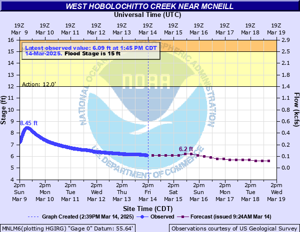
Critical Stages
12' - Action
15' - Flood
18' - Moderate
20' - Major
Latest Observation
Updated: 8:45 AM CST 12/14/25
Status: No Flooding
Stage: 5.55 ft
Flow: 0.0414 kcfs
Forecast
| Time | Stage (ft) | Flow (kcfs) |
|---|---|---|
| 12 PM 12/14 | 5.6 | 0.0452 |
| 6 PM 12/14 | 5.6 | 0.0452 |
| 12 AM 12/15 | 5.6 | 0.0452 |
| 6 AM 12/15 | 5.6 | 0.0452 |
| 12 PM 12/15 | 5.6 | 0.0452 |
| 6 PM 12/15 | 5.6 | 0.0452 |
| 12 AM 12/16 | 5.6 | 0.0452 |
| 6 AM 12/16 | 5.6 | 0.0452 |
| 12 PM 12/16 | 5.6 | 0.0452 |
| 6 PM 12/16 | 5.5 | 0.0378 |
| 12 AM 12/17 | 5.5 | 0.0378 |
| 6 AM 12/17 | 5.5 | 0.0378 |
| 12 PM 12/17 | 5.5 | 0.0378 |
| 6 PM 12/17 | 5.5 | 0.0378 |
| 12 AM 12/18 | 5.5 | 0.0378 |
| 6 AM 12/18 | 5.5 | 0.0378 |
| 12 PM 12/18 | 5.5 | 0.0378 |
| 6 PM 12/18 | 5.5 | 0.0378 |
| 12 AM 12/19 | 5.5 | 0.0378 |
| 6 AM 12/19 | 5.5 | 0.0378 |
| Time | Stage (ft) | Flow (kcfs) |
|---|---|---|
| 8:45 AM 12/14 | 5.55 | 0.0414 |
| 8:30 AM 12/14 | 5.55 | 0.0414 |
| 8:15 AM 12/14 | 5.55 | 0.0414 |
| 8:00 AM 12/14 | 5.55 | 0.0414 |
| 7:45 AM 12/14 | 5.55 | 0.0414 |
| 7:30 AM 12/14 | 5.55 | 0.0414 |
| 7:15 AM 12/14 | 5.55 | 0.0414 |
| 7:00 AM 12/14 | 5.55 | 0.0414 |
| 6:45 AM 12/14 | 5.55 | 0.0414 |
| 6:30 AM 12/14 | 5.55 | 0.0414 |
| 6:15 AM 12/14 | 5.55 | 0.0414 |
| 6:00 AM 12/14 | 5.54 | 0.0406 |
| 5:45 AM 12/14 | 5.52 | 0.0392 |
| 5:30 AM 12/14 | 5.5 | 0.0378 |
| 5:15 AM 12/14 | 5.51 | 0.0385 |
| 5:00 AM 12/14 | 5.54 | 0.0406 |
| 4:45 AM 12/14 | 5.54 | 0.0406 |
| 4:30 AM 12/14 | 5.53 | 0.0399 |
| 4:15 AM 12/14 | 5.53 | 0.0399 |
| 4:00 AM 12/14 | 5.53 | 0.0399 |
| 3:45 AM 12/14 | 5.54 | 0.0406 |
| 3:30 AM 12/14 | 5.54 | 0.0406 |
| 3:15 AM 12/14 | 5.54 | 0.0406 |
| 3:00 AM 12/14 | 5.54 | 0.0406 |
| 2:45 AM 12/14 | 5.54 | 0.0406 |
| 2:30 AM 12/14 | 5.54 | 0.0406 |
| 2:15 AM 12/14 | 5.54 | 0.0406 |
| 2:00 AM 12/14 | 5.54 | 0.0406 |
| 1:45 AM 12/14 | 5.54 | 0.0406 |
| 1:30 AM 12/14 | 5.54 | 0.0406 |
29.96' -
Flood of Record occurred on July, 5, 1916.
24' -
Widespread flooding will occur in Westchester Subdivision near Picayune. Many homes, business, and other buildings will be flooded. Evacuations will be necessary. Sections of MS Highway 43 will be impacted.
20' -
North Beech Road and Palestine Road in Picayune will be impassable. Several homes will be flooded in vicinity of the stream. Flooding threatens structures along MS Highway 43 near the bridge and fills culverts and ditches along bridge approach.
17' -
Some roads in the county inundated but passable. Homes in Westchester Subdivision, Picayune will be threatened. Water over a few roads in the city of Picayune will cause traffic problems. School bus traffic may need alternate routes. Beech Street and Westchester Subdivision below the confluence of the east and west branches will be subject to flooding in low places.
15' -
Some secondary roads near the stream north of Picayune will be inundated. Beech Street and Westchester Subdivision below the confluence of the east and west branches will be subject to flooding in low places.
12' -
Minor agricultural and forestry flooding will develop in rural areas.
10' -
Bank full with minor over bank flow will occur at low spots just below gage.
| Date | Stage (ft) |
|---|---|
| Jul 5, 1916 | 29.96 |
| Dec 15, 1961 | 24.96 |
| Aug 31, 2012 | 24.54 |
| Jan 21, 1993 | 23.43 |
| Apr 7, 1983 | 23.25 |
| May 12, 2019 | 22.97 |
| Mar 12, 2016 | 22.62 |
| Apr 4, 1979 | 22.58 |
| Feb 12, 1981 | 22.29 |
| May 12, 1972 | 22.05 |
| Apr 12, 1980 | 21.94 |
| Dec 25, 1973 | 21.32 |
| Apr 15, 1975 | 21.3 |
| Sep 13, 1973 | 21.13 |
| Aug 30, 2005 | 20.95 |
| Feb 13, 1966 | 20.57 |
| Jul 2, 2003 | 20.38 |
| Jan 8, 1998 | 20.33 |
| Apr 26, 2004 | 20.29 |
| Apr 22, 1977 | 20.21 |
Data provided by the National Weather Service.