Neches River at Steinhagen Lake
Critical Stages
Action
Flood
Moderate
Major
Latest Observation
Updated: 5:00 PM CST 12/6/25
Status: Not Defined
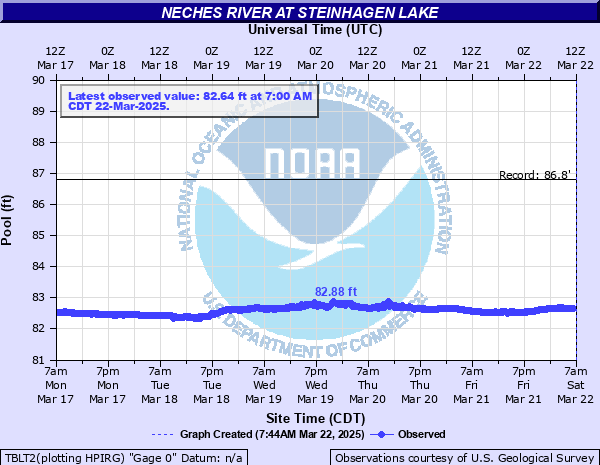
Stage: 82.76 ft
Flow: -999 kcfs
Forecast
Forecast not available for this location.
| Time | Stage (ft) | Flow (kcfs) |
|---|---|---|
| 6:00 PM 12/6 | 82.75 | -999 |
| 5:45 PM 12/6 | 82.75 | -999 |
| 5:30 PM 12/6 | 82.75 | -999 |
| 5:15 PM 12/6 | 82.76 | -999 |
| 5:00 PM 12/6 | 82.76 | -999 |
| 4:45 PM 12/6 | 82.77 | -999 |
| 4:30 PM 12/6 | 82.77 | -999 |
| 4:15 PM 12/6 | 82.77 | -999 |
| 4:00 PM 12/6 | 82.78 | -999 |
| 3:45 PM 12/6 | 82.79 | -999 |
| 3:30 PM 12/6 | 82.8 | -999 |
| 3:15 PM 12/6 | 82.81 | -999 |
| 3:00 PM 12/6 | 82.81 | -999 |
| 2:45 PM 12/6 | 82.81 | -999 |
| 2:30 PM 12/6 | 82.82 | -999 |
| 2:15 PM 12/6 | 82.82 | -999 |
| 2:00 PM 12/6 | 82.83 | -999 |
| 1:45 PM 12/6 | 82.83 | -999 |
| 1:30 PM 12/6 | 82.84 | -999 |
| 1:15 PM 12/6 | 82.84 | -999 |
| 1:00 PM 12/6 | 82.84 | -999 |
| 12:45 PM 12/6 | 82.84 | -999 |
| 12:30 PM 12/6 | 82.85 | -999 |
| 12:15 PM 12/6 | 82.86 | -999 |
| 12:00 PM 12/6 | 82.88 | -999 |
| 11:45 AM 12/6 | 82.87 | -999 |
| 11:30 AM 12/6 | 82.87 | -999 |
| 11:15 AM 12/6 | 82.87 | -999 |
| 11:00 AM 12/6 | 82.88 | -999 |
| 10:45 AM 12/6 | 82.89 | -999 |
95.1' -
The water is at the top of the instrument shelf
93' -
The water is at the maximum design level of the dam
85' -
The water is at the level of the dam's uncontrolled spillway crest
83' -
Normal operating level of the dam
| Date | Stage (ft) |
|---|---|
| May 1, 1984 | 86.81 |
| May 22, 1953 | 85.21 |
| May 6, 1944 | 84.98 |
| Jun 17, 2001 | 83.84 |
| May 25, 1999 | 83.75 |
| Oct 18, 1994 | 83.58 |
| Apr 5, 1997 | 83.46 |
| Aug 14, 2000 | 83.36 |
| Nov 30, 2004 | 83.34 |
| Jan 25, 2004 | 83.34 |
| May 2, 2003 | 83.34 |
| Aug 30, 1996 | 83.01 |
| May 21, 1953 | 82.85 |
| Sep 21, 2002 | 82.71 |
| May 1, 1935 | 82.56 |
| May 8, 1976 | 64.91 |
Data provided by the National Weather Service.