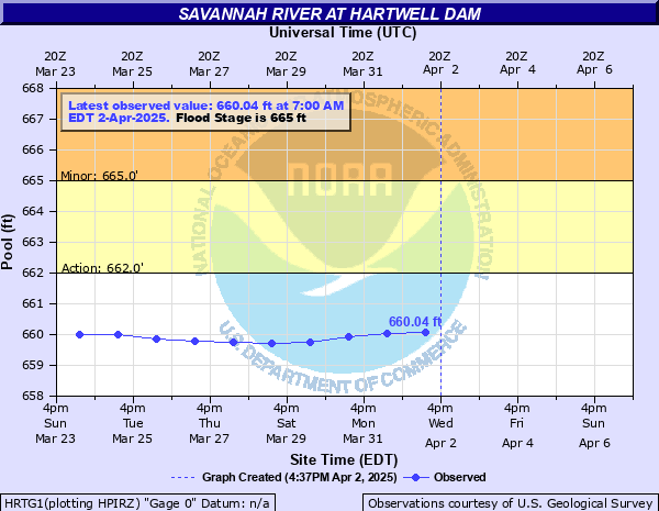
Savannah River at Hartwell Dam
Critical Stages
662' - Action
665' - Flood
670' - Moderate
680' - Major
Latest Observation
Updated: 7:03 PM LMT 12/31/00
Status: Obs Not Current
Stage: -999 ft
Flow: -999 kcfs
Forecast
Forecast not available for this location.
| Time | Stage (ft) | Flow (kcfs) |
|---|---|---|
| 7:00 AM 12/7 | 654.13 | -999 |
| 7:00 AM 12/6 | 654.23 | -999 |
| 7:00 AM 12/5 | 654.18 | -999 |
| 7:00 AM 12/4 | 654.33 | -999 |
| 7:00 AM 12/3 | 654.41 | -999 |
| 7:00 AM 12/2 | 654.6 | -999 |
| 7:00 AM 12/1 | 654.36 | -999 |
| 7:00 AM 11/30 | 654.29 | -999 |
| 7:00 AM 11/29 | 654.37 | -999 |
| 7:00 AM 11/28 | 654.69 | -999 |
| 7:00 AM 11/27 | 654.72 | -999 |
| 7:00 AM 11/26 | 654.74 | -999 |
| 7:00 AM 11/25 | 654.85 | -999 |
| 7:00 AM 11/24 | 655 | -999 |
| 7:00 AM 11/23 | 654.96 | -999 |
| 7:00 AM 11/22 | 654.91 | -999 |
| 7:00 AM 11/21 | 654.88 | -999 |
| 7:00 AM 11/20 | 654.85 | -999 |
| 7:00 AM 11/19 | 655 | -999 |
| 7:00 AM 11/18 | 655.12 | -999 |
| 7:00 AM 11/17 | 655.29 | -999 |
| 7:00 AM 11/16 | 655.26 | -999 |
| 7:00 AM 11/15 | 655.19 | -999 |
| 7:00 AM 11/14 | 655.15 | -999 |
| 7:00 AM 11/13 | 655.26 | -999 |
| 7:00 AM 11/12 | 655.32 | -999 |
| 7:00 AM 11/11 | 655.32 | -999 |
| 7:00 AM 11/10 | 655.14 | -999 |
| 7:00 AM 11/9 | 655.14 | -999 |
| 7:00 AM 11/8 | 655.14 | -999 |
675' -
Some campgrounds on islands on the lake may be affected.
670' -
Islands above and below the dam will become partially covered.
668' -
Water will be at the bottom of the bridge on Conerross Creek at Highway S-184, Martin Creek at Highway S-65 and Seneca Creek at Highway S-210.
667.5' -
Water will be at the bottom of the Highway SC71 bridge over 26 Mile Creek.
665' -
Recreation areas near the lake such as Long Point, Ashbury, Singing Pines, South Carolina River, Boyles and 12 Mile will be closed. Camping areas such as Springfield, Oconee Point, Watsadler and Georgia River will likely be closed. Creeks that drain into the lake will be effected by backwater especially on Old Jewell Road. Floating faclilites on the lake and along the banks of the lake will begin to flood.
664.5' -
Backwater affects on local streams will cause flooding of some low areas and roads such as dr johns road. Picnic areas, boat ramps, campgrounds and recreation areas near the lake shoreline will begin to flood.
663' -
At this stage water starts to flood low spots in yards of homes along the lake and water starts to backup into local creeks that feed into the lake.
662' -
Water management threshold, expect more frequent inflow forecasts.
660' -
Normal full pool level
| Date | Stage (ft) |
|---|---|
| Apr 8, 1964 | 665.4 |
| Jan 5, 2016 | 664.83 |
| Jul 9, 2013 | 664.79 |
| Apr 8, 1994 | 664.76 |
| Mar 17, 1996 | 664.08 |
| Mar 20, 1998 | 664.02 |
| May 6, 2003 | 663.44 |
| Dec 5, 1992 | 663.36 |
| Mar 6, 1995 | 662.95 |
| Jul 29, 2004 | 662.68 |
| Feb 8, 2010 | 662.63 |
| Apr 5, 2005 | 662.53 |
| Dec 7, 2009 | 662.27 |
| Apr 16, 2011 | 661.14 |
| Jan 30, 2006 | 659.67 |
| May 8, 2000 | 658.39 |
| May 7, 2007 | 658.33 |
| Jun 14, 2001 | 654.99 |
| May 21, 2002 | 653.22 |
| Mar 19, 2012 | 652.97 |
Data provided by the National Weather Service.