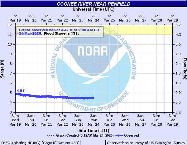
Oconee River near Penfield
Critical Stages
11' - Action
13' - Flood
18' - Moderate
27' - Major
Latest Observation
Updated: 6:00 AM EST 12/8/25
Status: No Flooding
Stage: 4.32 ft
Flow: 0.628 kcfs
Forecast
Forecast not available for this location.
| Time | Stage (ft) | Flow (kcfs) |
|---|---|---|
| 6:00 AM 12/8 | 4.32 | 0.628 |
| 5:45 AM 12/8 | 4.32 | 0.628 |
| 5:30 AM 12/8 | 4.31 | 0.625 |
| 5:15 AM 12/8 | 4.29 | 0.617 |
| 5:00 AM 12/8 | 4.31 | 0.625 |
| 4:45 AM 12/8 | 4.31 | 0.625 |
| 4:30 AM 12/8 | 4.31 | 0.625 |
| 4:15 AM 12/8 | 4.31 | 0.625 |
| 4:00 AM 12/8 | 4.31 | 0.625 |
| 3:45 AM 12/8 | 4.31 | 0.625 |
| 3:30 AM 12/8 | 4.32 | 0.628 |
| 3:15 AM 12/8 | 4.32 | 0.628 |
| 3:00 AM 12/8 | 4.32 | 0.628 |
| 2:45 AM 12/8 | 4.32 | 0.628 |
| 2:30 AM 12/8 | 4.32 | 0.628 |
| 2:15 AM 12/8 | 4.32 | 0.628 |
| 2:00 AM 12/8 | 4.32 | 0.628 |
| 1:45 AM 12/8 | 4.32 | 0.628 |
| 1:30 AM 12/8 | 4.31 | 0.625 |
| 1:15 AM 12/8 | 4.31 | 0.625 |
| 1:00 AM 12/8 | 4.31 | 0.625 |
| 12:45 AM 12/8 | 4.31 | 0.625 |
| 12:30 AM 12/8 | 4.31 | 0.625 |
| 12:15 AM 12/8 | 4.31 | 0.625 |
| 12:00 AM 12/8 | 4.31 | 0.625 |
| 11:45 PM 12/7 | 4.32 | 0.628 |
| 11:30 PM 12/7 | 4.32 | 0.628 |
| 11:15 PM 12/7 | 4.32 | 0.628 |
| 11:00 PM 12/7 | 4.33 | 0.632 |
| 10:45 PM 12/7 | 4.33 | 0.632 |
40' -
Widespread major flooding occurs. Several buildings are flooded out and Highway 15 bridge floods.
27' -
Major flooding begins. L.C. Curtis and Son Company offices flood.
22' -
Moderate flooding expands. Several farm access roads begin to flood.
18' -
Moderate flooding begins. Ward Road floods and cuts off access to L.C. Curtis and Son Sand and Gravel Company. Irrigation systems also begin to flood and need to be moved to higher ground.
17' -
Minor flooding continues to expand into fields...woodlands and pastures near the river. The water level is very close to Ward Road on the right bank. Flood waters will be approaching irrigation systems and they may need to be moved to higher ground.
15' -
Minor flooding continues to expand into fields...woodlands and pastures...mainly on the right bank of the river...upstream and downstream from the gage on the Georgia Highway 15 bridge.
13' -
Flood Stage is reached. Minor flooding occurs along the river upstream and downstream from the gage on the Georgia Highway 15 bridge. The right bank begins to overflow into agricultural land and pastures with a foot or two of water.
11' -
Bankfull conditions occur upstream and downstream from the gage on the Georgia Highway 15 bridge. Some low lying areas on the right bank just begin to overflow.
| Date | Stage (ft) |
|---|---|
| Mar 6, 1929 | 26.9 |
| Dec 19, 1919 | 26.9 |
| Apr 9, 1936 | 26.7 |
| Oct 1, 1989 | 25.92 |
| Feb 5, 1998 | 22.59 |
| Mar 17, 1990 | 22.3 |
| Mar 16, 1976 | 22.11 |
| Nov 8, 1977 | 22 |
| Mar 3, 1971 | 21.78 |
| Dec 31, 2015 | 21.53 |
| Mar 14, 1975 | 21.44 |
| Apr 15, 1979 | 20.9 |
| Mar 22, 2003 | 20.7 |
| Jan 13, 1972 | 20.63 |
| Dec 16, 1972 | 20.24 |
| Mar 9, 1998 | 20.13 |
| Jun 28, 1994 | 20.09 |
| Jul 4, 2003 | 19.8 |
| Oct 15, 2009 | 19.76 |
| Apr 21, 2019 | 19.58 |
Data provided by the National Weather Service.