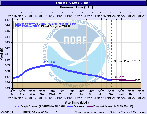
Mill Creek (IN) at Cagles Mill Lake
Critical Stages
704' - Action
704' - Flood
704' - Moderate
704' - Major
Latest Observation
Updated: 3:15 AM EST 12/10/25
Status: No Flooding
Stage: 636.06 ft
Flow: -999 kcfs
Forecast
| Time | Stage (ft) | Flow (kcfs) |
|---|---|---|
| 5 AM 12/10 | 636.06 | -999 |
| 6 AM 12/10 | 636.06 | -999 |
| 7 AM 12/10 | 636.06 | -999 |
| 8 AM 12/10 | 636.06 | -999 |
| 9 AM 12/10 | 636.05 | -999 |
| 10 AM 12/10 | 636.05 | -999 |
| 11 AM 12/10 | 636.05 | -999 |
| 12 PM 12/10 | 636.05 | -999 |
| 1 PM 12/10 | 636.05 | -999 |
| 2 PM 12/10 | 636.05 | -999 |
| 3 PM 12/10 | 636.05 | -999 |
| 4 PM 12/10 | 636.05 | -999 |
| 5 PM 12/10 | 636.05 | -999 |
| 6 PM 12/10 | 636.05 | -999 |
| 7 PM 12/10 | 636.05 | -999 |
| 8 PM 12/10 | 636.05 | -999 |
| 9 PM 12/10 | 636.05 | -999 |
| 10 PM 12/10 | 636.05 | -999 |
| 11 PM 12/10 | 636.05 | -999 |
| 12 AM 12/11 | 636.05 | -999 |
| 1 AM 12/11 | 636.05 | -999 |
| 2 AM 12/11 | 636.05 | -999 |
| 3 AM 12/11 | 636.05 | -999 |
| 4 AM 12/11 | 636.04 | -999 |
| 5 AM 12/11 | 636.04 | -999 |
| 6 AM 12/11 | 636.04 | -999 |
| 7 AM 12/11 | 636.04 | -999 |
| 8 AM 12/11 | 636.04 | -999 |
| 9 AM 12/11 | 636.04 | -999 |
| 10 AM 12/11 | 636.04 | -999 |
| 11 AM 12/11 | 636.04 | -999 |
| 12 PM 12/11 | 636.04 | -999 |
| 1 PM 12/11 | 636.04 | -999 |
| 2 PM 12/11 | 636.04 | -999 |
| 3 PM 12/11 | 636.04 | -999 |
| 4 PM 12/11 | 636.04 | -999 |
| 5 PM 12/11 | 636.04 | -999 |
| 6 PM 12/11 | 636.04 | -999 |
| 7 PM 12/11 | 636.04 | -999 |
| 8 PM 12/11 | 636.04 | -999 |
| 9 PM 12/11 | 636.04 | -999 |
| 10 PM 12/11 | 636.04 | -999 |
| 11 PM 12/11 | 636.03 | -999 |
| 12 AM 12/12 | 636.03 | -999 |
| 1 AM 12/12 | 636.03 | -999 |
| 2 AM 12/12 | 636.03 | -999 |
| 3 AM 12/12 | 636.03 | -999 |
| 4 AM 12/12 | 636.03 | -999 |
| 5 AM 12/12 | 636.03 | -999 |
| Time | Stage (ft) | Flow (kcfs) |
|---|---|---|
| 3:15 AM 12/10 | 636.06 | -999 |
| 3:00 AM 12/10 | 636.06 | -999 |
| 2:45 AM 12/10 | 636.07 | -999 |
| 2:30 AM 12/10 | 636.07 | -999 |
| 2:15 AM 12/10 | 636.07 | -999 |
| 2:00 AM 12/10 | 636.07 | -999 |
| 1:45 AM 12/10 | 636.07 | -999 |
| 1:30 AM 12/10 | 636.07 | -999 |
| 1:15 AM 12/10 | 636.07 | -999 |
| 1:00 AM 12/10 | 636.07 | -999 |
| 12:45 AM 12/10 | 636.07 | -999 |
| 12:30 AM 12/10 | 636.07 | -999 |
| 12:15 AM 12/10 | 636.07 | -999 |
| 12:00 AM 12/10 | 636.07 | -999 |
| 11:45 PM 12/9 | 636.07 | -999 |
| 11:30 PM 12/9 | 636.07 | -999 |
| 11:15 PM 12/9 | 636.07 | -999 |
| 11:00 PM 12/9 | 636.07 | -999 |
| 10:45 PM 12/9 | 636.07 | -999 |
| 10:30 PM 12/9 | 636.07 | -999 |
| 10:15 PM 12/9 | 636.07 | -999 |
| 10:00 PM 12/9 | 636.07 | -999 |
| 9:45 PM 12/9 | 636.07 | -999 |
| 9:30 PM 12/9 | 636.07 | -999 |
| 9:15 PM 12/9 | 636.07 | -999 |
| 9:00 PM 12/9 | 636.07 | -999 |
| 8:45 PM 12/9 | 636.07 | -999 |
| 8:30 PM 12/9 | 636.07 | -999 |
| 8:15 PM 12/9 | 636.07 | -999 |
| 8:00 PM 12/9 | 636.07 | -999 |
730' -
Top of Dam.
705' -
Dam Entrance Road closed at spillway.
704' -
Flood Pool - Spillway Crest. Flood Pool covers 4,840 acres and extends for 11 miles. There is a 1 0x0p+0nnual chance of occurrence of this level.
695' -
REMC power lines along SR 42 are dangerously close to the lake water surface.
692' -
REMC power lines along SR 42 barely high enough for boats to pass safely under especially those equipped with radio antennas.
684' -
State Road 42 closed at Cunot Bridge. There is a 10 0x0p+0nnual chance of occurrence of this level.
676.6' -
State Road 42 closed at Doe Creek Bridge.
675' -
River Road near Cataract Falls closed. Camp Otto Road just east of Mill Creek and downstream of Upper Falls flooded at this elevation or slightly higher.
672' -
Jib Crane underwater. Cunot Boat Club and Lakeshore Hill licensed areas inaccessible. Pit toilet at DNR marina pumped out. There is a 20 0x0p+0nnual chance of occurrence of this level.
660' -
Meridian Line County Road (Doe Creek) closed. Lakeside Yacht Club licensed area inaccessbile. There is a 100 0x0p+0nnual chance of occurrence of this level.
656.5' -
Stored emergency gate underwater.
655' -
Indiana Gear Works, Cataract Yacht Club, Forest Cove, Cataract Highlands and Hidden Hollow licensed areas inaccessible.
652' -
Ivanwald licensed area probably inaccessible.
651' -
Lieber Recreation Area boat ramp underwater. Haltom Heights inaccessbile.
650' -
Lieber Recreation Area Marina parking lot closed. Countryside Estates, Croy Crest, Minkler and Highland Lakeview licensed areas inaccessible.
647.5' -
Cunot Boat Ramp inaccessible. Launching from the roadway begins.
644' -
Emergency gate entrance slots underwater.
643.5' -
Lieber Recreation Area beach closed.
640.5' -
Beach road closed.
639.5' -
Summer Pool Elevation. Summer Pool covers an estimated 1,600 acres and extends about 10.3 miles.
636' -
Winter pool elevation. Winter pool covers 1,400 acres and extends 10 miles.
631' -
Cunot launch ramp becomes totally exposed.
629.9' -
Control tower gage becomes unusable.
629' -
Beach area and IDNR launch ramp are totally exposed. The bottom of the staff gage is exposed. Three lead connections of the Cathodic Protection field become exposed.
628' -
Old Cunot launch ramp is totally exposed.
| Date | Stage (ft) |
|---|---|
| Jun 18, 2008 | 692.07 |
| May 6, 2011 | 691.18 |
| Jun 14, 1996 | 690.36 |
| Aug 30, 1979 | 689.6 |
| May 17, 2002 | 686.16 |
| Jan 18, 2005 | 683.87 |
| Jan 23, 2007 | 682.66 |
| Dec 8, 1993 | 682.25 |
| Jun 15, 1981 | 681.1 |
| Apr 11, 2018 | 680.51 |
| May 15, 1961 | 679.3 |
| Feb 14, 1999 | 677.68 |
| Feb 15, 1969 | 677 |
| Dec 17, 1985 | 676.7 |
| May 20, 2009 | 676.53 |
| Apr 30, 2013 | 676.14 |
| Mar 15, 1982 | 675.8 |
| May 14, 2017 | 675.44 |
| Mar 15, 1963 | 674.8 |
| Jan 13, 1991 | 674.42 |
Data provided by the National Weather Service.