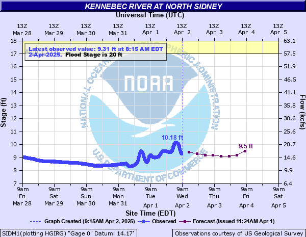
Kennebec River at North Sidney
Critical Stages
17' - Action
20' - Flood
25' - Moderate
29' - Major
Latest Observation
Updated: 9:15 PM EST 12/7/25
Status: No Flooding
Stage: 6.07 ft
Flow: 3.24 kcfs
Forecast
| Time | Stage (ft) | Flow (kcfs) |
|---|---|---|
| 1 AM 12/8 | 5.9 | 2.91 |
| 7 AM 12/8 | 6 | 3.1 |
| 1 PM 12/8 | 6 | 3.1 |
| 7 PM 12/8 | 6 | 3.1 |
| 1 AM 12/9 | 6 | 3.1 |
| 7 AM 12/9 | 6 | 3.1 |
| 1 PM 12/9 | 6.1 | 3.3 |
| 7 PM 12/9 | 6.1 | 3.3 |
| 1 AM 12/10 | 6.1 | 3.3 |
| 7 AM 12/10 | 6.1 | 3.3 |
| Time | Stage (ft) | Flow (kcfs) |
|---|---|---|
| 9:15 PM 12/7 | 6.07 | 3.24 |
| 9:00 PM 12/7 | 6.07 | 3.24 |
| 8:45 PM 12/7 | 6.06 | 3.22 |
| 8:30 PM 12/7 | 6.07 | 3.24 |
| 8:15 PM 12/7 | 6.07 | 3.24 |
| 8:00 PM 12/7 | 6.08 | 3.26 |
| 7:45 PM 12/7 | 6.08 | 3.26 |
| 7:30 PM 12/7 | 6.09 | 3.28 |
| 7:15 PM 12/7 | 6.09 | 3.28 |
| 7:00 PM 12/7 | 6.09 | 3.28 |
| 6:45 PM 12/7 | 6.1 | 3.3 |
| 6:30 PM 12/7 | 6.1 | 3.3 |
| 6:15 PM 12/7 | 6.1 | 3.3 |
| 6:00 PM 12/7 | 6.1 | 3.3 |
| 5:45 PM 12/7 | 6.1 | 3.3 |
| 5:30 PM 12/7 | 6.1 | 3.3 |
| 5:15 PM 12/7 | 6.1 | 3.3 |
| 5:00 PM 12/7 | 6.09 | 3.28 |
| 4:45 PM 12/7 | 6.1 | 3.3 |
| 4:30 PM 12/7 | 6.1 | 3.3 |
| 4:15 PM 12/7 | 6.11 | 3.32 |
| 4:00 PM 12/7 | 6.11 | 3.32 |
| 3:45 PM 12/7 | 6.11 | 3.32 |
| 3:30 PM 12/7 | 6.12 | 3.34 |
| 3:15 PM 12/7 | 6.11 | 3.32 |
| 3:00 PM 12/7 | 6.12 | 3.34 |
| 2:45 PM 12/7 | 6.11 | 3.32 |
| 2:30 PM 12/7 | 6.1 | 3.3 |
| 2:15 PM 12/7 | 6.09 | 3.28 |
| 2:00 PM 12/7 | 6.08 | 3.26 |

39' -
The river is nearing or exceeding flood levels seen during the historic 1987 flood. Follow the directions of local officials if you are asked to evacuate.
34' -
Many homes and businesses are severely flooded or are totally isolated for an extended duration between Waterville and North Sidney. This is a very dangerous and life threatening situation. Roadways will remain unsafe during and after the storm and driving will be extremely hazardous.
31.5' -
Extensive flooding with major damage to roads, bridges and structures from Fairfield to Sidney. Flood levels are comparable with the severe December 2023 flooding. Several main thruways flooded making travel very difficult. Don’t put first responders at risk, follow local officials’ instructions on evacuation and safety precautions.
29' -
Major flooding occurs. Closure of Route 201 is possible near Davis Street in Fairfield and Halifax Street in Winslow. In Fairfield, impacts expand to multiple properties along Upper Main Street, Water Street, and Bunker Island. Follow the directions of local officials if you are asked to evacuate.
25' -
Moderate flooding occurs. In Fairfield, water surrounds properties and inundates basements of low lying properties off Upper Main Street and Water Street. Impacts expand to buildings on Mill Road and Lithgow Street in Winslow. Impacts along Route 201 in Winslow are possible if concurrent with high flows along the Sebasticook River.
22.5' -
In Fairfield, floodwaters expand from Water Street to Dyer Court cutting off access to properties. Floodwaters reach Lithgow Street in Winslow.
20' -
Lowest portions of Winslow and Fairfield begin to flood. The most flood prone areas include Lithgow Street in Winslow and Water Street in Fairfield. Residents along the river in low lying areas should prepare for flooding if additional rises occur.
17' -
The river is at bankfull in low lying areas, and high flows could cause some erosion.
| Date | Stage (ft) |
|---|---|
| Apr 2, 1987 | 39.31 |
| Dec 19, 2023 | 32.32 |
| Jun 1, 1984 | 26.6 |
| Apr 28, 1979 | 26.4 |
| Apr 26, 1983 | 25.69 |
| Jan 28, 1986 | 25.56 |
| May 2, 2023 | 24.9 |
| Apr 12, 1993 | 23.61 |
| Apr 4, 2005 | 22.29 |
| Dec 19, 2003 | 22.23 |
| Apr 30, 2008 | 22.08 |
| Apr 16, 2014 | 21.25 |
| May 13, 1989 | 21.24 |
| Dec 14, 2010 | 20.85 |
| Apr 13, 2024 | 20.62 |
| Oct 25, 1990 | 18.9 |
| Jun 4, 2012 | 18.79 |
| Mar 29, 1992 | 18.77 |
| Oct 24, 1981 | 17.33 |
| Mar 8, 2024 | 17.25 |
Data provided by the National Weather Service.
