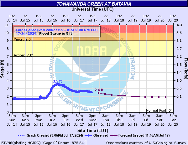
Tonawanda Creek at Batavia
Critical Stages
7' - Action
9' - Flood
10' - Moderate
12' - Major
Latest Observation
Updated: 4:00 AM EST 12/16/25
Status: No Flooding
Stage: 1.86 ft
Flow: 0.0531 kcfs
Forecast
| Time | Stage (ft) | Flow (kcfs) |
|---|---|---|
| 7 AM 12/16 | 1.8 | 0.044 |
| 1 PM 12/16 | 1.8 | 0.044 |
| 7 PM 12/16 | 1.8 | 0.044 |
| 1 AM 12/17 | 1.8 | 0.044 |
| 7 AM 12/17 | 1.8 | 0.044 |
| 1 PM 12/17 | 1.8 | 0.044 |
| 7 PM 12/17 | 1.8 | 0.044 |
| 1 AM 12/18 | 1.8 | 0.044 |
| 7 AM 12/18 | 1.8 | 0.044 |
| Time | Stage (ft) | Flow (kcfs) |
|---|---|---|
| 4:00 AM 12/16 | 1.86 | 0.0531 |
| 3:45 AM 12/16 | 1.86 | 0.0531 |
| 3:30 AM 12/16 | 1.86 | 0.0531 |
| 3:15 AM 12/16 | 1.86 | 0.0531 |
| 3:00 AM 12/16 | 1.86 | 0.0531 |
| 2:45 AM 12/16 | 1.86 | 0.0531 |
| 2:30 AM 12/16 | 1.86 | 0.0531 |
| 2:15 AM 12/16 | 1.86 | 0.0531 |
| 2:00 AM 12/16 | 1.86 | 0.0531 |
| 1:45 AM 12/16 | 1.86 | 0.0531 |
| 1:30 AM 12/16 | 1.86 | 0.0531 |
| 1:15 AM 12/16 | 1.86 | 0.0531 |
| 1:00 AM 12/16 | 1.86 | 0.0531 |
| 12:45 AM 12/16 | 1.86 | 0.0531 |
| 12:30 AM 12/16 | 1.86 | 0.0531 |
| 12:15 AM 12/16 | 1.86 | 0.0531 |
| 12:00 AM 12/16 | 1.86 | 0.0531 |
| 11:45 PM 12/15 | 1.86 | 0.0531 |
| 11:30 PM 12/15 | 1.86 | 0.0531 |
| 11:15 PM 12/15 | 1.86 | 0.0531 |
| 11:00 PM 12/15 | 1.86 | 0.0531 |
| 10:45 PM 12/15 | 1.86 | 0.0531 |
| 10:30 PM 12/15 | 1.85 | 0.0515 |
| 10:15 PM 12/15 | 1.85 | 0.0515 |
| 10:00 PM 12/15 | 1.85 | 0.0515 |
| 9:45 PM 12/15 | 1.85 | 0.0515 |
| 9:30 PM 12/15 | 1.85 | 0.0515 |
| 9:15 PM 12/15 | 1.85 | 0.0515 |
| 9:00 PM 12/15 | 1.85 | 0.0515 |
| 8:45 PM 12/15 | 1.85 | 0.0515 |
12' -
Major flood, considerable residential and commercial flooding from the west side of Batavia through East Pembroke. Widespread flooding in low lying areas and feeder streams along the entire reach of Tonawanda Creek, including the Tonawanda Indian Reservation and extending into the Iroquois National Wildlife Refuge.
10' -
Moderate flood, flooding along West Main Street and South Main Street in Batavia and along the creek from Batavia to East Pembroke, extending to the Tonawanda Indian Reservation. Flooding will mainly impact roads, with some residential and commerical flooding possible.
9' -
Flood stage, some flooding in Batavia, possibly impacting Kibbe Park, Walnut Street, and Law Street. Flooding in rural areas of Alexander and the lowlands of the Alabama Swamps with some road closures likely.
7' -
Action stage, high flows. Minor impact on some rural roads north of Alexander.
| Date | Stage (ft) |
|---|---|
| Apr 6, 1947 | 13.85 |
| Mar 29, 1950 | 13.73 |
| Mar 2, 1955 | 13.44 |
| Mar 31, 1960 | 12.7 |
| Feb 25, 1985 | 12.45 |
| Jan 9, 1998 | 12.44 |
| Mar 7, 1956 | 12.07 |
| Dec 22, 2013 | 11.94 |
| Mar 15, 2007 | 11.89 |
| Dec 28, 2008 | 11.72 |
| Jul 9, 1998 | 11.7 |
| Dec 30, 1984 | 11.59 |
| May 5, 1976 | 11.31 |
| Nov 7, 2017 | 11.27 |
| Jan 24, 1999 | 11 |
| Sep 25, 1977 | 10.89 |
| Jan 22, 1959 | 10.87 |
| Jun 24, 1972 | 10.82 |
| Feb 13, 2009 | 10.7 |
| Mar 9, 2009 | 10.57 |
Data provided by the National Weather Service.