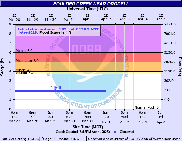
Boulder Creek (CO) near Orodell
Critical Stages
3.7' - Action
4' - Flood
5' - Moderate
6' - Major
Latest Observation
Updated: 10:15 AM MST 12/6/25
Status: No Flooding
Stage: 2.18 ft
Flow: 0.0791 kcfs
Forecast
Forecast not available for this location.
| Time | Stage (ft) | Flow (kcfs) |
|---|---|---|
| 10:15 AM 12/6 | 2.18 | 0.0791 |
| 10:00 AM 12/6 | 2.19 | 0.0815 |
| 9:45 AM 12/6 | 2.19 | 0.0815 |
| 9:30 AM 12/6 | 2.19 | 0.0815 |
| 9:15 AM 12/6 | 2.2 | 0.084 |
| 9:00 AM 12/6 | 2.2 | 0.084 |
| 8:45 AM 12/6 | 2.2 | 0.084 |
| 8:30 AM 12/6 | 2.2 | 0.084 |
| 8:15 AM 12/6 | 2.2 | 0.084 |
| 8:00 AM 12/6 | 2.2 | 0.084 |
| 7:45 AM 12/6 | 2.21 | 0.086 |
| 7:30 AM 12/6 | 2.21 | 0.086 |
| 7:15 AM 12/6 | 2.21 | 0.086 |
| 7:00 AM 12/6 | 2.21 | 0.086 |
| 6:45 AM 12/6 | 2.21 | 0.086 |
| 6:30 AM 12/6 | 2.22 | 0.0881 |
| 6:17 AM 12/6 | 2.22 | 0.0881 |
| 6:15 AM 12/6 | 2.22 | 0.0881 |
| 6:02 AM 12/6 | 2.22 | 0.0881 |
| 6:00 AM 12/6 | 2.22 | 0.0881 |
| 5:47 AM 12/6 | 2.21 | 0.086 |
| 5:45 AM 12/6 | 2.21 | 0.086 |
| 5:32 AM 12/6 | 2.22 | 0.0881 |
| 5:30 AM 12/6 | 2.22 | 0.0881 |
| 5:15 AM 12/6 | 2.22 | 0.0881 |
| 5:00 AM 12/6 | 2.22 | 0.0881 |
| 4:45 AM 12/6 | 2.21 | 0.086 |
| 4:30 AM 12/6 | 2.21 | 0.086 |
| 4:15 AM 12/6 | 2.21 | 0.086 |
| 4:00 AM 12/6 | 2.21 | 0.086 |
11' -
This level represents a flood that has a 0.2-percent chance of being equaled or exceeded in any given year. For more information click <a href="inundation/faq_google.php">here</a>.
8.8' -
This level represents a flood that has a 1-percent chance of being equaled or exceeded in any given year. For more information click <a href="inundation/faq_google.php">here</a>.
7.7' -
This level represents a flood that has a 2-percent chance of being equaled or exceeded in any given year. For more information click <a href="inundation/faq_google.php">here</a>
6' -
This is a life threatening flood in Boulder Canyon. There is major flooding of homes and severe damage to Highway 119. There is also extensive flooding of streets near the creek in the city of Boulder.
5.5' -
Roads in Boulder Canyon are threatened. Considerable flooding occurs in downtown Boulder.
5' -
There is moderate flooding of roads, homes and businesses in Boulder Canyon.
4.8' -
This level represents a flood that has a 10-percent chance of being equaled or exceeded in any given year. For more information click <a href="inundation/faq_google.php">here</a>.
4.5' -
This would be the highest flow at Orodell since records began in 1907. A number of private bridges crossing the creek in Boulder Canyon flood. The library on Canyon Avenue in the city of Boulder is affected. County Road 73 is overtopped.
4' -
Debris in the creek could block flow at private bridges. This level represents a flood that has a 10-percent chance of being equaled or exceeded in any given year. For more information click <a href="inundation/faq_google.php">here</a>.
3.7' -
Water flows into the lowest areas adjacent to the creek.
3.4' -
Typically a tubing ban is enacted on Boulder Creek when the flow is around 700-800 cfs.
| Date | Stage (ft) |
|---|---|
| Jun 6, 1921 | 4.31 |
| Jun 2, 2003 | 4.27 |
| May 7, 1969 | 4.07 |
| Jul 24, 1965 | 4.01 |
| Jun 21, 1947 | 4 |
| Sep 12, 2013 | 3.99 |
| Jun 7, 1952 | 3.96 |
| Jun 21, 1951 | 3.93 |
| Jun 29, 1957 | 3.87 |
| Jun 21, 1941 | 3.86 |
| Jun 28, 1983 | 3.77 |
| Jun 6, 1958 | 3.75 |
| Jun 22, 1918 | 3.74 |
| Jul 9, 2011 | 3.73 |
| Jun 7, 1997 | 3.7 |
| Jun 6, 1949 | 3.7 |
| Jun 19, 1971 | 3.67 |
| Jun 16, 1960 | 3.66 |
| Jun 21, 1995 | 3.64 |
| Jun 11, 1953 | 3.64 |
Data provided by the National Weather Service.