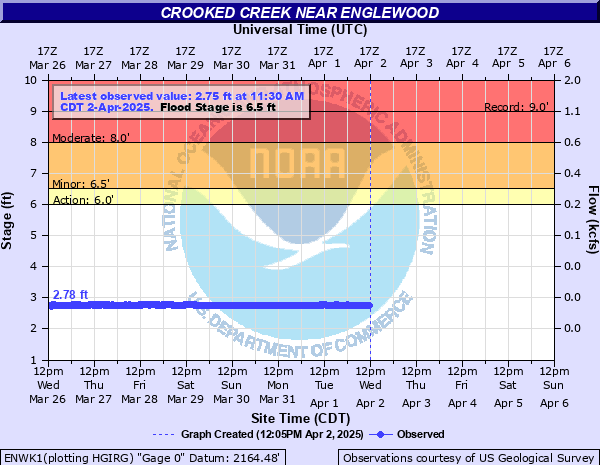
Crooked Creek (KS) near Englewood
Critical Stages
6' - Action
6.5' - Flood
8' - Moderate
10' - Major
Latest Observation
Updated: 5:30 AM CST 12/16/25
Status: No Flooding
Stage: 2.53 ft
Flow: 0.0056 kcfs
Forecast
Forecast not available for this location.
| Time | Stage (ft) | Flow (kcfs) |
|---|---|---|
| 5:30 AM 12/16 | 2.53 | 0.0056 |
| 5:15 AM 12/16 | 2.54 | 0.0058 |
| 5:00 AM 12/16 | 2.54 | 0.0058 |
| 4:45 AM 12/16 | 2.54 | 0.0058 |
| 4:30 AM 12/16 | 2.53 | 0.0056 |
| 4:15 AM 12/16 | 2.53 | 0.0056 |
| 4:00 AM 12/16 | 2.53 | 0.0056 |
| 3:45 AM 12/16 | 2.54 | 0.0058 |
| 3:30 AM 12/16 | 2.52 | 0.0055 |
| 3:15 AM 12/16 | 2.53 | 0.0056 |
| 3:00 AM 12/16 | 2.53 | 0.0056 |
| 2:45 AM 12/16 | 2.59 | 0.0066 |
| 2:30 AM 12/16 | 2.54 | 0.0058 |
| 2:15 AM 12/16 | 2.52 | 0.0055 |
| 2:00 AM 12/16 | 2.54 | 0.0058 |
| 1:45 AM 12/16 | 2.53 | 0.0056 |
| 1:30 AM 12/16 | 2.53 | 0.0056 |
| 1:15 AM 12/16 | 2.54 | 0.0058 |
| 1:00 AM 12/16 | 2.55 | 0.0059 |
| 12:45 AM 12/16 | 2.53 | 0.0056 |
| 12:30 AM 12/16 | 2.54 | 0.0058 |
| 12:15 AM 12/16 | 2.53 | 0.0056 |
| 12:00 AM 12/16 | 2.53 | 0.0056 |
| 11:45 PM 12/15 | 2.54 | 0.0058 |
| 11:30 PM 12/15 | 2.53 | 0.0056 |
| 11:15 PM 12/15 | 2.54 | 0.0058 |
| 11:00 PM 12/15 | 2.54 | 0.0058 |
| 10:45 PM 12/15 | 2.54 | 0.0058 |
| 10:30 PM 12/15 | 2.55 | 0.0059 |
| 10:15 PM 12/15 | 2.54 | 0.0058 |
12' -
Record flooding is now possible along most of Crooked Creek in southern Meade County to the Kansas-Oklahoma state line. Floodwaters will rise to 5 feet or higher outside of the main river channel, and substantially cover the floodplain. This flood may approach the record floods of August 31, 1963, and May 20, 1955.
11' -
Prepare for near-record flooding along Crooked Creek in southern Meade County, as floodwaters 4 feet deep or more course their way downstream to the Kansas-Oklahoma border.
10' -
Prepare for major flooding of three feet or more along many portions of Crooked Creek in southern Meade County as floodwaters push further out onto the floodplain.
9' -
Prepare for moderate inundations of two to three feet along many segments of Crooked Creek in southern Meade County as floodwaters continue to move further out onto the floodplain. The county road east of the bridge 12 miles west of Englewood will begin to overflow at about 8.5 feet.
8' -
Expect moderate flooding along most streches of Crooked Creek in southern Meade County. Both riverbanks will experience inundations up to 2 feet as the floodwaters continue their expansion onto the floodplain.
7' -
Prepare for minor inundations of one or more feet along the Crooked Creek in southern Meade County as floodwaters leave the main channel and moves out onto the floodplain.
6.5' -
Prepare for minor overflows along portions of crooked creek in southern meade county as the creek moves out onto the floodplain.
| Date | Stage (ft) |
|---|---|
| Aug 31, 1963 | 9 |
| Jun 7, 1963 | 8.9799995422363 |
| Apr 2, 1973 | 8.21 |
| May 20, 1955 | 8.0100002288818 |
| Aug 20, 1958 | 7.9400000572205 |
| May 17, 2003 | 7.9 |
| Jul 7, 2023 | 7.81 |
| May 1, 1978 | 7.61 |
| May 23, 1951 | 7.5900001525879 |
| Mar 27, 1973 | 7.5 |
| May 18, 1951 | 7.4000000953674 |
| Jul 27, 1950 | 7.1500000953674 |
| Jul 24, 1962 | 7 |
| Nov 17, 1971 | 6.9800000190735 |
| Apr 26, 1949 | 6.9299998283386 |
| Jun 4, 1949 | 6.8200001716614 |
| May 30, 2015 | 6.81 |
| Mar 24, 1973 | 6.7399997711182 |
| May 14, 1951 | 6.7199997901917 |
| Jul 29, 1950 | 6.6999998092651 |
Data provided by the National Weather Service.