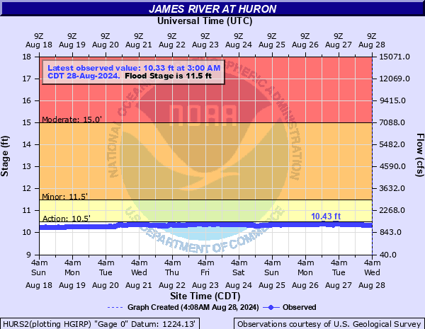
James River at Huron
Critical Stages
10.5' - Action
11.5' - Flood
15' - Moderate
19' - Major
Latest Observation
Updated: 4:00 PM CST 12/15/25
Status: No Flooding
Stage: 9.55 ft
Flow: 0.388 kcfs
Forecast
Forecast not available for this location.
| Time | Stage (ft) | Flow (kcfs) |
|---|---|---|
| 5:00 PM 12/15 | 9.55 | 0.388 |
| 4:45 PM 12/15 | 9.55 | 0.388 |
| 4:30 PM 12/15 | 9.56 | 0.396 |
| 4:15 PM 12/15 | 9.56 | 0.396 |
| 4:00 PM 12/15 | 9.55 | 0.388 |
| 3:45 PM 12/15 | 9.57 | 0.404 |
| 3:30 PM 12/15 | 9.55 | 0.388 |
| 3:15 PM 12/15 | 9.55 | 0.388 |
| 3:00 PM 12/15 | 9.56 | 0.396 |
| 2:45 PM 12/15 | 9.56 | 0.396 |
| 2:30 PM 12/15 | 9.57 | 0.404 |
| 2:15 PM 12/15 | 9.55 | 0.388 |
| 2:00 PM 12/15 | 9.56 | 0.396 |
| 1:45 PM 12/15 | 9.56 | 0.396 |
| 1:30 PM 12/15 | 9.55 | 0.388 |
| 1:15 PM 12/15 | 9.56 | 0.396 |
| 1:00 PM 12/15 | 9.57 | 0.404 |
| 12:45 PM 12/15 | 9.56 | 0.396 |
| 12:30 PM 12/15 | 9.57 | 0.404 |
| 12:15 PM 12/15 | 9.56 | 0.396 |
| 12:00 PM 12/15 | 9.57 | 0.404 |
| 11:45 AM 12/15 | 9.56 | 0.396 |
| 11:30 AM 12/15 | 9.56 | 0.396 |
| 11:15 AM 12/15 | 9.57 | 0.404 |
| 11:00 AM 12/15 | 9.57 | 0.404 |
| 10:45 AM 12/15 | 9.57 | 0.404 |
| 10:30 AM 12/15 | 9.56 | 0.396 |
| 10:15 AM 12/15 | 9.57 | 0.404 |
| 10:00 AM 12/15 | 9.56 | 0.396 |
| 9:45 AM 12/15 | 9.57 | 0.404 |
25.5' -
Water overtops the dike at the wastewater treatment plant.
22' -
Riverside Park in Huron begins to flood from water overtopping the dike.
21.5' -
Water reaches the bottom of the bridge on Highway 14 and reaches the top of the dike in Memorial Park.
20.5' -
Memorial Park in Huron will be flooded. The lowest portion of 221st in northern Sanborn County begins to flood.
19.5' -
Hwy 14 may begin flooding west of the bridge in Huron. Water reaches the bottom of the bridge at the gaging location.
19' -
Most county roads along the river east of Highway 37 are flooded.
17' -
3rd Street east of the bridge in Huron begins flooding.
16.5' -
Portions of Jersey, Riverside, and Sherman streets in Huron may begin flooding.
15' -
Approximately 16000 acres of agricultural land around Huron will be flooded. The lowest portion of Jersey and Waibel Dr may also be flooded if flow from the creek is high.
14' -
A few county and township roads in Beadle County will be flooded.
11.5' -
Rural and agricultural areas begin to experience flooding
10.5' -
The lowest banks begin to be overtopped flooding low lying area near the river.
| Date | Stage (ft) |
|---|---|
| Apr 6, 1997 | 21.28 |
| Mar 26, 2011 | 20.07 |
| Mar 25, 2010 | 19.72 |
| Apr 10, 2001 | 18.14 |
| May 7, 2007 | 17.58 |
| Apr 24, 2019 | 17.25 |
| May 19, 1995 | 16.86 |
| Mar 21, 2020 | 16.75 |
| Apr 13, 1969 | 16.7 |
| May 3, 2009 | 16.64 |
| Mar 22, 1922 | 16.5 |
| Mar 22, 1994 | 16.17 |
| Apr 2, 1962 | 15.8 |
| Apr 24, 2023 | 15.69 |
| Apr 2, 1960 | 15.42 |
| Apr 15, 1952 | 15.23 |
| Mar 30, 1978 | 15.22 |
| May 3, 1986 | 14.81 |
| Mar 27, 1948 | 14.48 |
| May 24, 1950 | 14.3 |
Data provided by the National Weather Service.