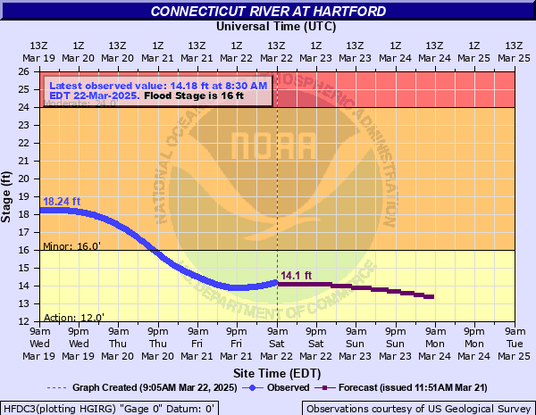
Connecticut River at Hartford
Critical Stages
12' - Action
16' - Flood
24' - Moderate
28' - Major
Latest Observation
Updated: 10:30 AM EST 12/9/25
Status: No Flooding
Stage: 1.61 ft
Flow: 4.83 kcfs
Forecast
| Time | Stage (ft) | Flow (kcfs) |
|---|---|---|
| 1 PM 12/9 | 1.1 | 3.3 |
| 2 PM 12/9 | 1.3 | 3.9 |
| 3 PM 12/9 | 1.7 | 5.1 |
| 4 PM 12/9 | 2.2 | 6.55 |
| 5 PM 12/9 | 2.7 | 7.9 |
| 6 PM 12/9 | 3 | 8.7 |
| 7 PM 12/9 | 3.2 | 9.35 |
| 8 PM 12/9 | 3.1 | 9.02 |
| 9 PM 12/9 | 2.9 | 8.43 |
| 10 PM 12/9 | 2.7 | 7.9 |
| 11 PM 12/9 | 2.4 | 7.09 |
| 12 AM 12/10 | 2.1 | 6.27 |
| 1 AM 12/10 | 1.8 | 5.4 |
| 2 AM 12/10 | 1.6 | 4.8 |
| 3 AM 12/10 | 1.6 | 4.8 |
| 4 AM 12/10 | 1.7 | 5.1 |
| 5 AM 12/10 | 1.9 | 5.7 |
| 6 AM 12/10 | 2.1 | 6.27 |
| 7 AM 12/10 | 2.2 | 6.55 |
| 8 AM 12/10 | 2.1 | 6.27 |
| 9 AM 12/10 | 2 | 6 |
| 10 AM 12/10 | 1.9 | 5.7 |
| 11 AM 12/10 | 1.7 | 5.1 |
| 12 PM 12/10 | 1.5 | 4.5 |
| 1 PM 12/10 | 1.4 | 4.2 |
| 2 PM 12/10 | 1.2 | 3.6 |
| 3 PM 12/10 | 1.2 | 3.6 |
| 4 PM 12/10 | 1.3 | 3.9 |
| 5 PM 12/10 | 1.7 | 5.1 |
| 6 PM 12/10 | 2.1 | 6.27 |
| 7 PM 12/10 | 2.5 | 7.36 |
| 8 PM 12/10 | 2.6 | 7.63 |
| 9 PM 12/10 | 2.6 | 7.63 |
| 10 PM 12/10 | 2.4 | 7.09 |
| 11 PM 12/10 | 2.2 | 6.55 |
| 12 AM 12/11 | 1.9 | 5.7 |
| 1 AM 12/11 | 1.6 | 4.8 |
| 2 AM 12/11 | 1.3 | 3.9 |
| 3 AM 12/11 | 1.2 | 3.6 |
| 4 AM 12/11 | 1.1 | 3.3 |
| 5 AM 12/11 | 1.2 | 3.6 |
| 6 AM 12/11 | 1.3 | 3.9 |
| 7 AM 12/11 | 1.4 | 4.2 |
| 8 AM 12/11 | 1.5 | 4.5 |
| 9 AM 12/11 | 1.6 | 4.8 |
| 10 AM 12/11 | 1.5 | 4.5 |
| 11 AM 12/11 | 1.4 | 4.2 |
| 12 PM 12/11 | 1.2 | 3.6 |
| 1 PM 12/11 | 1 | 3 |
| 2 PM 12/11 | 0.8 | -999 |
| 3 PM 12/11 | 0.7 | -999 |
| 4 PM 12/11 | 0.6 | -999 |
| 5 PM 12/11 | 0.7 | -999 |
| 6 PM 12/11 | 1 | 3 |
| 7 PM 12/11 | 1.3 | 3.9 |
| 8 PM 12/11 | 1.4 | 4.2 |
| 9 PM 12/11 | 1.3 | 3.9 |
| 10 PM 12/11 | 1.2 | 3.6 |
| 11 PM 12/11 | 1 | 3 |
| 12 AM 12/12 | 0.7 | -999 |
| 1 AM 12/12 | 0.4 | -999 |
| 2 AM 12/12 | 0.2 | -999 |
| 3 AM 12/12 | 0 | -999 |
| 7 AM 12/12 | 0 | -999 |
| Time | Stage (ft) | Flow (kcfs) |
|---|---|---|
| 11:30 AM 12/9 | 1.38 | 4.14 |
| 11:15 AM 12/9 | 1.43 | 4.29 |
| 11:00 AM 12/9 | 1.48 | 4.44 |
| 10:45 AM 12/9 | 1.54 | 4.62 |
| 10:30 AM 12/9 | 1.61 | 4.83 |
| 10:15 AM 12/9 | 1.67 | 5.01 |
| 10:00 AM 12/9 | 1.73 | 5.19 |
| 9:45 AM 12/9 | 1.79 | 5.37 |
| 9:30 AM 12/9 | 1.85 | 5.55 |
| 9:15 AM 12/9 | 1.92 | 5.76 |
| 9:00 AM 12/9 | 1.98 | 5.94 |
| 8:45 AM 12/9 | 2.05 | 6.14 |
| 8:30 AM 12/9 | 2.11 | 6.3 |
| 8:15 AM 12/9 | 2.17 | 6.47 |
| 8:00 AM 12/9 | 2.23 | 6.63 |
| 7:45 AM 12/9 | 2.3 | 6.82 |
| 7:30 AM 12/9 | 2.37 | 7.01 |
| 7:15 AM 12/9 | 2.45 | 7.23 |
| 7:00 AM 12/9 | 2.52 | 7.42 |
| 6:45 AM 12/9 | 2.58 | 7.58 |
| 6:30 AM 12/9 | 2.63 | 7.71 |
| 6:15 AM 12/9 | 2.67 | 7.82 |
| 6:00 AM 12/9 | 2.69 | 7.87 |
| 5:45 AM 12/9 | 2.68 | 7.85 |
| 5:30 AM 12/9 | 2.65 | 7.77 |
| 5:15 AM 12/9 | 2.6 | 7.63 |
| 5:00 AM 12/9 | 2.53 | 7.44 |
| 4:45 AM 12/9 | 2.45 | 7.23 |
| 4:31 AM 12/9 | 2.35 | 6.96 |
| 4:30 AM 12/9 | 2.35 | 6.96 |
32' -
This is a serious and life threatening flood episode. Follow the direction of your local emergency management officals. If asked to evacuate, do so immediately. All flood protection measures must be rushed to completion in flood prone areas. Towns from Windsor Locks and East Windsor south through Middletown, Haddam and Portland to the river mouth at Old Saybrook will experience significant flooding outside of levees and flood protection walls.
30' -
This is a serious and life threatening flood episode. Follow the direction of your local emergency management officals. If asked to evacuate, do so immediately. All flood protection measures must be rushed to completion in flood prone areas. Towns from Windsor Locks and East Windsor south through Middletown, Haddam and Portland to Old Saybrook will experience significant flooding outside of levees and flood protection walls.
28' -
This is a serious flood episode. Follow the direction of your local emergency management officals. If asked to evacuate, do so immediately. All flood protection measures must be rushed to completion in flood prone areas. Towns from Windsor Locks and East Windsor south through Haddam and Portland will experience significant flooding outside of levees and flood protection walls. Further downstream through Cromwell, Middletown and further downstream this is a serious potentially life threatening flood.
26' -
Moderate flooding will occur along a large reach of the river from Windsor Locks and East Windsor, south through Haddam and Portland. Many river roads will be closed and some localized evacuations may be required. Follow the directions of local emergency management officials. Further downstream significant flooding will continue to impact low lying homes and businesses from Wethersfield south through Middletown and Middle Haddam, downstream to the mouth of the river in Old Saybrook.
24' -
Flooding affects some residential areas below Hartford through Rocky Hill. Upstream of Hartford, flooding is likely to affect Windsor Locks, East Windsor and Windsor. Should localized evacuations be necessary, act quickly. Further downstream major river flooding will impact towns along the Connecticut River from Middletown and Portland downstream through Chester and Essex. Many roads near the river will be flooded. Some local evacuations may be needed.
23' -
Flooding affects some residential areas below Hartford through Rocky Hill, including some roadways. Upstream of Hartford, flooding is likely to affect Windsor Locks, East Windsor and Windsor. Should localized evacuations be necessary, act quickly. Know alternate routes for travel in your location should roads along the river become flooded and impassable. Further downstream flooding increases through Middletown and Portland to Old Saybrook. Some evacuations of low lying areas may be needed.
22' -
Flooding affects some residential areas below Hartford through Rocky Hill, including some roadways. Upstream of Hartford, flooding is likely to affect Windsor Locks, East Windsor and Windsor. Should localized evacuations be necessary, act quickly. Further downstream flooding will likely result in the evacuation of low lying area along River Road in Cromwell and Meadow Road in Portland. Flooding increases from Middletown and Portland to the river mouth at Old Saybrook.
21' -
Flooding is expected along the river in portions of Wethersfield, Glastonbury and Rocky Hill. The high waters and swift flows will disrupt some cross river ferry services. Upstream of Hartford flooding will continue to affect portions of Windsor. Immediate river roads may become impassable. Further downstream flooding will likely result in the evacuation of low lying areas along River Road in Cromwell and River Road in Portland. Flooding increases along the river from Middletown to Old Saybrook.
20' -
Flooding is expected along the river in portions of Wethersfield, Glastonbury, Rocky Hill and Cromwell. The high waters and swift flows will disrupt some cross river ferry services. Upstream of Hartford, flooding will continue to affect portions of Windsor. Immediate river roads may become impassable in all of these communities. Further downstream flooding will continue to overspread sections of Portland, Middletown as well as Chester.
19' -
Flooding of low lying areas below Hartford is expected, especially in areas that are outside of levee protection. Flooding also affects low lying areas upstream of Hartford, including a portion of Windsor where the Farmington River empties into the Connecticut River. Further downstream flooding closes most of Meadow Road, Route 17A, in Portland. Flooding impacts the Middletown Marina and Meadow Farms. In Cromwell, portions of River Road will be closed. Flooding continues along the river through Essex.
18' -
Flooding of low lying areas below Hartford is expected, especially in areas that are outside of levee protection. Flooding also affects low lying areas upstream of Hartford, including a portion of Windsor where the Farmington River empties into the Connecticut River. Further downstream flooding is expected in low lying sections along the Connecticut River from Wethersfield and Glastonbury downstream through Cromwell, Middletown and Portland. Boating interests should prepare for swift river flows.
17' -
Lowland flooding is expected along the Connecticut River from Hartford through Wethersfield and Glastonbury, primarily outside of levee protection. This will affect several riverside roadways as well as several park and recreational facilities. Further downstream flooding is expected in low lying sections along the Connecticut River from Wethersfield and Glastonbury downstream through Cromwell, Middletown and Portland.
16' -
Minor flooding is expected in several low lying areas outside levee protection in Hartford, as well as downstream through Wethersfield and Glastonbury. Further downstream flooding is likely in the vicinity of Meadow Road, Route 17A, in the Gildersleeve section of Portland. A portion of this roadway will likely be closed. This includes the Exchange Club of Portland Fairgrounds. Boating interests should prepare for a period of swift river flows during this period.
14' -
Recreational boaters may need to secure their boats as the river elevation exceeds some docks. Swift river flows will also cause increasingly difficult sailing conditions.
| Date | Stage (ft) |
|---|---|
| Mar 21, 1936 | 37.6 |
| Sep 23, 1938 | 35.4 |
| Jun 1, 1984 | 30.74 |
| Aug 20, 1955 | 30.6 |
| May 1, 1854 | 29.3 |
| Dec 10, 1927 | 29 |
| Apr 21, 1862 | 28.2 |
| Apr 7, 1960 | 27.6 |
| Mar 29, 1843 | 26.7 |
| Apr 9, 1901 | 26.4 |
| Mar 29, 1913 | 26.3 |
| Apr 23, 1869 | 26.2 |
| Mar 3, 1896 | 26 |
| Apr 21, 1933 | 26 |
| Dec 14, 2023 | 25.96 |
| Mar 20, 1859 | 25.9 |
| Oct 6, 1869 | 25.8 |
| Jan 3, 1692 | 25.7 |
| Apr 8, 1987 | 25.6 |
| Jan 2, 1949 | 25.52 |
Data provided by the National Weather Service.