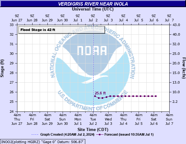
Verdigris River near Inola
Critical Stages
42' - Action
42' - Flood
45' - Moderate
48' - Major
Latest Observation
Updated: 6:09 PM LMT 12/31/00
Status: Obs Not Current
Stage: -999 ft
Flow: -999 kcfs
Forecast
| Time | Stage (ft) | Flow (kcfs) |
|---|---|---|
| 6 PM 12/15 | 24.9 | 1.11 |
| 12 AM 12/16 | 24.9 | 1.11 |
| 6 AM 12/16 | 24.9 | 1.11 |
| 12 PM 12/16 | 24.9 | 1.11 |
| 6 PM 12/16 | 24.9 | 1.11 |
| 12 AM 12/17 | 24.9 | 1.11 |
| 6 AM 12/17 | 24.9 | 1.11 |
| 12 PM 12/17 | 24.9 | 1.11 |
| 6 PM 12/17 | 24.9 | 1.11 |
| 12 AM 12/18 | 24.9 | 1.11 |
| 6 AM 12/18 | 24.9 | 1.11 |
| 12 PM 12/18 | 24.9 | 1.11 |
| 6 PM 12/18 | 24.9 | 1.11 |
| 12 AM 12/19 | 24.9 | 1.11 |
| 6 AM 12/19 | 24.9 | 1.11 |
| 12 PM 12/19 | 24.9 | 1.11 |
| 6 PM 12/19 | 24.9 | 1.11 |
| 12 AM 12/20 | 24.9 | 1.11 |
| 6 AM 12/20 | 24.9 | 1.11 |
Observation history not available.
54' -
near record flooding occurs between the Port of Catoosa to the pool of Newt Graham Lock and Dam. Some 73,000 acres of land along the river, including landings and parks, are inundated. The flood of record was 54.93 feet on May 21, 1943. This is an extremely dangerous and life threatening situation.
52' -
very severe flooding occurs from the twin Highway 412 bridges downstream. Parks and landings along the Verdigris River are inundated. This will approach the flood of October 5, 1959 when the river crested at 53.20 feet. This is an extremely dangerous and life threatening situation.
50' -
severe flooding occurs from the twin Highway 412 bridges downstream. Landings and parks along the river are covered to depths of several feet. This will approach the flood of May 25, 1957 when the river crested at 51.50 feet. This is an extremely dangerous and life threatening situation.
48' -
widespread agricultural flooding occurs. Some landings and parks along the river are inundated. This is a dangerous situation.
46' -
widespread agricultural flooding occurs. Parks along the river are inundated and some landings may be affected.
45' -
moderate agricultural flooding occurs. Parks along the river are flooded and some landings may be affected. This will approach the flooding which occurred on August 18, 1961 when the river crested at 44.38 feet.
44' -
widespread minor agricultural flooding occurs. Parks along the river may be flooded.
42' -
minor agricultural flooding occurs.
| Date | Stage (ft) |
|---|---|
| May 21, 1943 | 54.93 |
| Oct 5, 1959 | 53.2 |
| Jun 16, 1957 | 52.75 |
| Jun 27, 1948 | 52.4 |
| Jul 8, 1951 | 52.32 |
| Nov 1, 1941 | 52 |
| May 12, 1943 | 51.8 |
| Apr 22, 1945 | 51.7 |
| Oct 4, 1945 | 51.65 |
| May 25, 1957 | 51.5 |
| Oct 8, 1941 | 50.83 |
| Apr 14, 1944 | 50.64 |
| Apr 23, 1941 | 49.79 |
| Jun 15, 1941 | 49.39 |
| Apr 23, 1942 | 49.22 |
| Jul 25, 1948 | 49.02 |
| Jun 26, 1942 | 48.82 |
| Apr 22, 1947 | 48.74 |
| Apr 13, 1942 | 48.18 |
| Oct 19, 1941 | 47.32 |
Data provided by the National Weather Service.