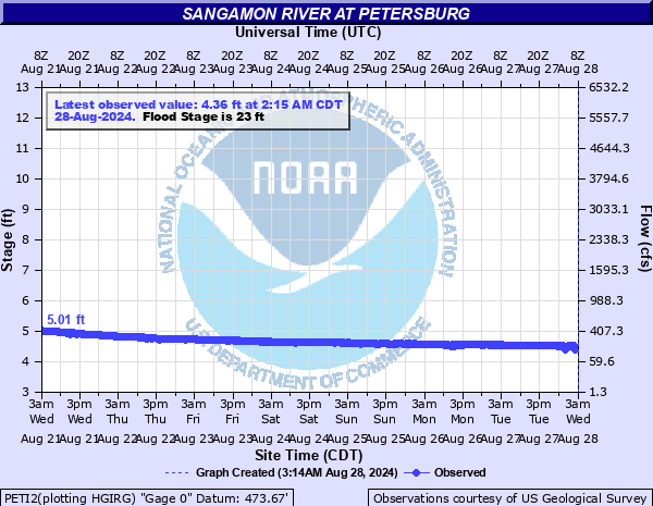
Sangamon River at Petersburg
Critical Stages
18' - Action
23' - Flood
24' - Moderate
33' - Major
Latest Observation
Updated: 6:15 AM CST 12/6/25
Status: No Flooding
Stage: 4.13 ft
Flow: 0.0816 kcfs
Forecast
Forecast not available for this location.
| Time | Stage (ft) | Flow (kcfs) |
|---|---|---|
| 6:15 AM 12/6 | 4.13 | 0.0816 |
| 6:00 AM 12/6 | 4.13 | 0.0816 |
| 5:45 AM 12/6 | 4.13 | 0.0816 |
| 5:30 AM 12/6 | 4.13 | 0.0816 |
| 5:15 AM 12/6 | 4.13 | 0.0816 |
| 5:00 AM 12/6 | 4.12 | 0.0797 |
| 4:45 AM 12/6 | 4.12 | 0.0797 |
| 4:30 AM 12/6 | 4.12 | 0.0797 |
| 4:15 AM 12/6 | 4.12 | 0.0797 |
| 4:00 AM 12/6 | 4.12 | 0.0797 |
| 3:45 AM 12/6 | 4.12 | 0.0797 |
| 3:30 AM 12/6 | 4.12 | 0.0797 |
| 3:15 AM 12/6 | 4.12 | 0.0797 |
| 3:00 AM 12/6 | 4.12 | 0.0797 |
| 2:45 AM 12/6 | 4.12 | 0.0797 |
| 2:30 AM 12/6 | 4.12 | 0.0797 |
| 2:15 AM 12/6 | 4.12 | 0.0797 |
| 2:00 AM 12/6 | 4.12 | 0.0797 |
| 1:45 AM 12/6 | 4.12 | 0.0797 |
| 1:30 AM 12/6 | 4.13 | 0.0816 |
| 1:15 AM 12/6 | 4.13 | 0.0816 |
| 1:00 AM 12/6 | 4.13 | 0.0816 |
| 12:45 AM 12/6 | 4.13 | 0.0816 |
| 12:30 AM 12/6 | 4.13 | 0.0816 |
| 12:15 AM 12/6 | 4.13 | 0.0816 |
| 12:00 AM 12/6 | 4.13 | 0.0816 |
| 11:45 PM 12/5 | 4.13 | 0.0816 |
| 11:30 PM 12/5 | 4.14 | 0.0835 |
| 11:15 PM 12/5 | 4.14 | 0.0835 |
| 11:00 PM 12/5 | 4.14 | 0.0835 |
29' -
Route 123 is closed. Water overtops Illinois Midland railroad tracks at 4th Street.
25' -
Some residences on the east side of Petersburg flood.
23' -
Extensive agricultural and lowland flooding occurs.
22' -
Altig Bridge Ave. closed due to water over the west approach roadway.
21' -
Park and recreational land near the river in Petersburg is flooded.
15' -
Water begins to flood agricultural areas and local parks near the river.
| Date | Stage (ft) |
|---|---|
| May 20, 1943 | 33.9 |
| May 14, 2002 | 30.75 |
| Dec 31, 2015 | 30.55 |
| Apr 14, 1994 | 29.84 |
| May 11, 1996 | 27.45 |
| Jan 25, 1974 | 26.5 |
| Jan 17, 2005 | 26.3 |
| May 3, 1970 | 26.1 |
| Jan 18, 2005 | 26.08 |
| Apr 23, 2013 | 25.67 |
| Nov 3, 2009 | 24.24 |
| Apr 21, 1969 | 24.2 |
| Nov 21, 2009 | 24.1 |
| Jun 4, 2013 | 24.05 |
| May 7, 2017 | 23.92 |
| May 20, 2020 | 23.8 |
| Jun 26, 2010 | 23.71 |
| Jan 10, 2005 | 23.62 |
| Jun 25, 2019 | 23.59 |
| Dec 28, 2009 | 23.4 |
Data provided by the National Weather Service.