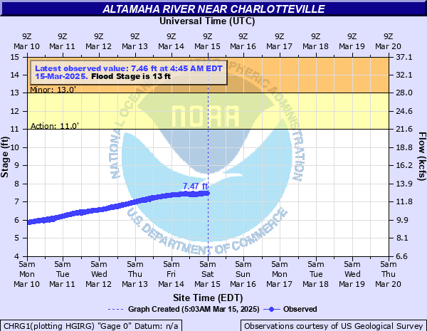
Altamaha River near Charlotteville
Critical Stages
11' - Action
13' - Flood
20' - Moderate
25' - Major
Latest Observation
Updated: 2:45 AM EST 12/16/25
Status: No Flooding
Stage: 2.26 ft
Flow: 4.23 kcfs
Forecast
Forecast not available for this location.
| Time | Stage (ft) | Flow (kcfs) |
|---|---|---|
| 2:45 AM 12/16 | 2.26 | 4.23 |
| 2:30 AM 12/16 | 2.26 | 4.23 |
| 2:15 AM 12/16 | 2.27 | 4.24 |
| 2:00 AM 12/16 | 2.27 | 4.24 |
| 1:45 AM 12/16 | 2.27 | 4.24 |
| 1:30 AM 12/16 | 2.27 | 4.24 |
| 1:15 AM 12/16 | 2.27 | 4.24 |
| 1:00 AM 12/16 | 2.27 | 4.24 |
| 12:45 AM 12/16 | 2.27 | 4.24 |
| 12:30 AM 12/16 | 2.27 | 4.24 |
| 12:15 AM 12/16 | 2.28 | 4.25 |
| 12:00 AM 12/16 | 2.27 | 4.24 |
| 11:45 PM 12/15 | 2.28 | 4.25 |
| 11:30 PM 12/15 | 2.28 | 4.25 |
| 11:15 PM 12/15 | 2.28 | 4.25 |
| 11:00 PM 12/15 | 2.28 | 4.25 |
| 10:45 PM 12/15 | 2.28 | 4.25 |
| 10:30 PM 12/15 | 2.28 | 4.25 |
| 10:15 PM 12/15 | 2.28 | 4.25 |
| 10:00 PM 12/15 | 2.29 | 4.26 |
| 9:45 PM 12/15 | 2.29 | 4.26 |
| 9:30 PM 12/15 | 2.29 | 4.26 |
| 9:15 PM 12/15 | 2.29 | 4.26 |
| 9:00 PM 12/15 | 2.29 | 4.26 |
| 8:45 PM 12/15 | 2.29 | 4.26 |
| 8:30 PM 12/15 | 2.29 | 4.26 |
| 8:15 PM 12/15 | 2.29 | 4.26 |
| 8:00 PM 12/15 | 2.3 | 4.28 |
| 7:45 PM 12/15 | 2.29 | 4.26 |
| 7:30 PM 12/15 | 2.29 | 4.26 |
29' -
Record flooding surrounds the U.S. Highway 221 bridge. Flood waters 13 feet deep on Towns Bluff Lane will flood 20 elevated homes with some up to 7 feet deep. Flood waters 17 feet deep will cover large portions of Three Rivers Lane...Altamaha River Road and Ogle Sandbar Road. The elevated homes in this are will be flooded near 7 feet deep. Large portions of Towns Bluff Park and the Bullard Creek WMA will be flooded up to 10 feet deep. The Towns Bluff Heritage Center will begin to flood.
27' -
Widespread inundation flooding expands from the Highway 221 bridge. Flood waters 11 feet deep on Towns Bluff Lane will flood 20 elevated homes with some up to 5 feet deep. Flood waters 15 feet deep will cover large portions of Three Rivers Lane...Altamaha River Road and Ogle Sandbar Road. The elevated homes in this area will be flooded near 5 feet deep. Portions of Towns Bluff Park and the Bullard Creek WMA will be flooded up to 8 feet deep. Flood waters will reach the foundation of the Heritage Center.
25' -
Major flooding begins. Widespread inundation flooding surrounds the Highway 221 bridge. Flood waters up to 9 feet deep on Towns Bluff Lane will flood all 20 elevated homes on the road with some up to 3 feet deep. Flood waters up to 13 feet deep will cover large portions of Three Rivers Lane...Altamaha River Road and Ogle Sandbar Road. All of the elevated homes in this area will be flooded a few feet deep. Portions of Towns Bluff Park and the Bullard Creek WMA will be flooded up to 6 feet deep.
24' -
Significant flooding expands upstream and downstream from the Highway 221 bridge. Flood waters will be up to 8 feet deep on Towns Bluff Lane. Flood waters will be near two feet deep in some of the elevated homes. Flood waters up to 12 feet deep will cover large portions of Three Rivers Lane...Altamaha River Road and Ogle Sandbar Road. Most of the elevated homes in this area will be flooded a few feet deep. The parking lot at Towns Bluff Park and most of Uvalda Landing Road will be under 5 feet of water.
22' -
Significant flooding expands upstream and downstream from the Highway 221 bridge. Flood waters will be near 6 feet deep on Towns Bluff Lane and will reach the bottoms of some of the elevated homes. Flood waters up to 10 feet deep will cover large portions of Three Rivers Lane...Altamaha River Road and Ogle Sandbar Road. Some of the elevated homes in this area will begin to flood. The parking lot at Towns Bluff Park and a pavilion and picnic area off Uvalda Landing Road will be under 3 feet of water.
21' -
Significant flooding continues upstream and downstream from the Highway 221 bridge. Flood waters will be near 5 feet deep on Towns Bluff Lane and flood the concrete slab foundations of the elevated homes. Flooding expands further into Montgomery County with the water 7 to 9 feet deep over large portions of Three Rivers Lane...Altamaha River Road and Ogle Sandbar Road. The parking lot at Towns Bluff Park and a pavilion and picnic area off Uvalda Landing Road will be flooded in Jeff Davis County.
20' -
Moderate flooding begins. Significant flooding occurs upstream and downstream from the Highway 221 bridge. Flood waters will be near 4 feet deep on Towns Bluff Lane and flood the concrete slab foundations of the elevated homes. Flooding expands further into Montgomery county with the water 6 to 8 feet deep over large portions of Three Rivers Lane...Altamaha River Road and Ogle Sandbar Road. The parking lot at Towns Bluff Park and portions of Uvalda Landing Road will be flooded in Jeff Davis County.
19' -
Minor flooding expands upstream and downstream from the Highway 221 bridge. Flood waters near 3 feet deep cover Towns Bluff Lane and flood the slab foundations of the elevated homes. Flooding expands further into Montgomery County with the water 5 to 7 feet deep over large portions of Three Rivers Lane...Altamaha River Road and Ogle Sandbar Road. The water reaches the top of boat ramps and parking lots will begin to flood in Towns Bluff Park and along the end of Uvalda Landing Road in Jeff Davis County.
18' -
Minor flooding expands further into the woodlands along the river upstream and downstream from the gage on the U.S. Highway 221 bridge. Flood waters will completely cover Towns Bluff Lane by the bridge and begin to flood the slab foundations of the elevated homes. Flood waters expand further into south Montgomery County around 1.5 miles upstream from the gage. The water will be 4 to 6 feet deep over large portions of Three Rivers Lane...Altamaha River Road and Ogle Sandbar Road.
16' -
Minor flooding expands into the woodlands along the river upstream and downstream from the gage on the U.S. Highway 221 bridge. The water will be one to two feet deep over portions of Towns Bluff Lane by the bridge. Flood waters continue to expand further into south Montgomery County around 1.5 miles upstream from the gage. The water will be 2 to 4 feet over large portions of Three Rivers Lane...Altamaha River Road and Ogle Sandbar Road.
14' -
Minor flooding continues in the woodlands along the river upstream and downstream from the gage on the U.S. Highway 221 bridge. The water covers the low portion and entrance of Towns Bluff Lane by the bridge. The public boat ramp is under two feet of water. Flood waters expand further into south Montgomery County around 1.5 miles upstream from the gage. The water will be one to two feet deep over portions of Three Rivers Lane...Altamaha River Road and Ogle Sandbar Road.
13' -
Flood stage is reached. Minor flooding occurs in the woodlands along the river upstream and downstream from the gage on the U.S. Highway 221 bridge. The water reaches the top of the public boat ramp by the bridge. Flood waters expand in low lying areas in south Montgomery County around 1.5 miles upstream from the gage. The water will begin to cover portions of Three Rivers Lane...Altamaha River Road and Ogle Sandbar Road.
11' -
Bankfull conditions occur along the river upstream and downstream from the gage on the U.S. Highway 221 bridge. Some flooding begins in low lying areas around 1.5 miles upstream from the gage in south Montgomery County. The water will approach portions of Three Rivers Lane...Altamaha River Road and Ogle Sandbar Road.
| Date | Stage (ft) |
|---|---|
| Jan 22, 1925 | 29 |
| Apr 16, 1936 | 27.5 |
| Mar 11, 1929 | 26.3 |
| Dec 8, 1948 | 25.8 |
| Oct 9, 1929 | 24.8 |
| Aug 22, 1928 | 24.7 |
| Mar 16, 1998 | 24.5 |
| Mar 30, 1944 | 24.4 |
| Mar 13, 1971 | 24.25 |
| Mar 11, 1966 | 23.8 |
| Mar 31, 1942 | 23.3 |
| Jul 16, 1994 | 23.3 |
| Mar 25, 1975 | 23.3 |
| Jan 6, 2016 | 23.08 |
| Apr 8, 2009 | 22.81 |
| Mar 21, 1980 | 22.8 |
| Feb 12, 1998 | 22.6 |
| Mar 9, 1939 | 22.6 |
| Mar 7, 1961 | 22.5 |
| Feb 27, 2020 | 22.49 |
Data provided by the National Weather Service.