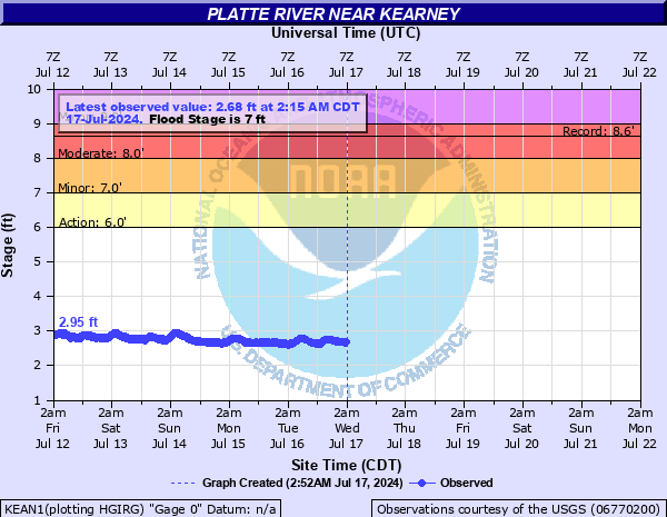
Platte River near Kearney
Critical Stages
6' - Action
7' - Flood
8' - Moderate
9' - Major
Latest Observation
Updated: 2:15 PM CST 12/15/25
Status: No Flooding
Stage: 3.21 ft
Flow: 1.19 kcfs
Forecast
Forecast not available for this location.
| Time | Stage (ft) | Flow (kcfs) |
|---|---|---|
| 2:15 PM 12/15 | 3.21 | 1.19 |
| 2:00 PM 12/15 | 3.22 | 1.21 |
| 1:45 PM 12/15 | 3.22 | 1.21 |
| 1:30 PM 12/15 | 3.23 | 1.23 |
| 1:15 PM 12/15 | 3.23 | 1.23 |
| 1:00 PM 12/15 | 3.24 | 1.25 |
| 12:45 PM 12/15 | 3.24 | 1.25 |
| 12:30 PM 12/15 | 3.25 | 1.27 |
| 12:15 PM 12/15 | 3.26 | 1.29 |
| 12:00 PM 12/15 | 3.27 | 1.31 |
| 11:45 AM 12/15 | 3.28 | 1.34 |
| 11:30 AM 12/15 | 3.3 | 1.38 |
| 11:15 AM 12/15 | 3.29 | 1.36 |
| 11:00 AM 12/15 | 3.27 | 1.31 |
| 10:45 AM 12/15 | 3.23 | 1.23 |
| 10:30 AM 12/15 | 3.2 | 1.17 |
| 10:15 AM 12/15 | 3.17 | 1.1 |
| 10:00 AM 12/15 | 3.02 | 0.812 |
| 9:45 AM 12/15 | 2.96 | 0.709 |
| 9:30 AM 12/15 | 2.95 | 0.693 |
| 9:15 AM 12/15 | 2.96 | 0.709 |
| 9:00 AM 12/15 | 2.96 | 0.709 |
| 8:45 AM 12/15 | 2.96 | 0.709 |
| 8:30 AM 12/15 | 2.96 | 0.709 |
| 7:15 AM 12/15 | 3.01 | 0.795 |
| 7:00 AM 12/15 | 3.03 | 0.829 |
| 6:45 AM 12/15 | 3.03 | 0.829 |
| 6:30 AM 12/15 | 3.05 | 0.864 |
| 6:15 AM 12/15 | 3.06 | 0.882 |
| 6:00 AM 12/15 | 3.07 | 0.901 |
7.5' -
Water will surround homes and may begin to impact lowest sub-floors in the Sweetwater neighborhoods both north and south of Interstate 80. There will also be extensive flooding at the Nebraska Youth Camp located off of Sweetwater Avenue cutting off access to the camp, but most of the structures will be just above the flood water. Interstate 80 is at a high enough elevation that it will not be impacted.
7' -
An access road to a small housing subdivision located directly south of Gibbon, on the south side of Interstate 80, at the northeast corner of Lowell Road and 24th Road, including Woodland Road, will begin to flood.
6' -
Minor flooding of rural lowlands occur.
| Date | Stage (ft) |
|---|---|
| Feb 24, 1994 | 8.62 |
| May 26, 2008 | 7.95 |
| Jul 10, 2019 | 7.6 |
| Jun 11, 1995 | 7.43 |
| Jun 29, 1983 | 7.42 |
| Jan 11, 1985 | 7.4 |
| Sep 28, 2013 | 7.22 |
| Jun 4, 2015 | 7.21 |
| Feb 5, 2011 | 7.19 |
| Jun 13, 1984 | 6.64 |
| Dec 23, 1998 | 6.63 |
| Feb 22, 1993 | 6.62 |
| Feb 22, 1985 | 6.57 |
| May 12, 1999 | 6.51 |
| Jun 25, 2011 | 6.5 |
| Jun 17, 2010 | 6.47 |
| Jan 3, 2017 | 6.22 |
| Mar 8, 1989 | 6.15 |
| Jun 14, 2014 | 6.14 |
| Mar 26, 1996 | 6.02 |
Data provided by the National Weather Service.