Wood River near Riverdale
Critical Stages
10' - Action
11' - Flood
15' - Moderate
20' - Major
Latest Observation
Updated: 6:09 PM LMT 12/31/00
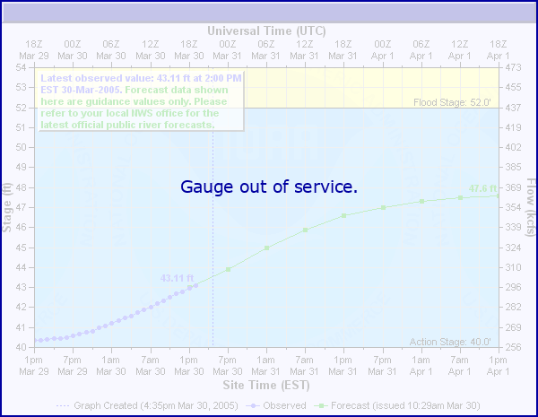
Status: Out Of Service
Stage: -999 ft
Flow: -999 kcfs
Forecast
Forecast not available for this location.
Observation history not available.
20' -
The town of Riverdale and Highway 40 are not in the flood plain, and are not subject to flooding even at extreme flows.
15' -
Lowland flooding becomes more widespread.
11' -
Lowland flooding occurs.
| Date | Stage (ft) |
|---|---|
| Jun 22, 1947 | 19.75 |
| Jun 14, 1967 | 15.54 |
| Jun 29, 1965 | 13.98 |
| Jul 20, 1958 | 12.27 |
| Mar 17, 1948 | 12.07 |
| Mar 25, 1960 | 11.55 |
| Jun 25, 1968 | 11.15 |
| Jun 17, 1957 | 10.97 |
| Jun 10, 1949 | 10.97 |
| Mar 15, 1978 | 10.95 |
| Jun 17, 1955 | 10.88 |
| Mar 19, 1969 | 10.78 |
| Jun 19, 1962 | 10.76 |
| Feb 11, 1966 | 10.75 |
| Jul 9, 1950 | 9.57 |
| Jul 5, 1956 | 9.03 |
| May 27, 1953 | 8.58 |
| Feb 23, 1980 | 8.43 |
| Jul 27, 1979 | 8.41 |
| Jul 4, 1959 | 8.35 |
Data provided by the National Weather Service.