Sturgeon River near Chassell
Critical Stages
10' - Action
10.5' - Flood
13' - Moderate
17' - Major
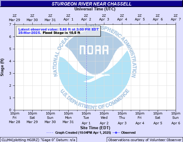
Latest Observation
Updated: 7:03 PM LMT 12/31/00
Status: Obs Not Current
Stage: -999 ft
Flow: -999 kcfs
Forecast
Forecast not available for this location.
Observation history not available.
17' -
Water flowing over the highest point of the Sturgeon River Road bridge driving surface
15' -
Water is flowing over road surface of both bridge approaches
14.5' -
Water reaches the bottom of the bridge between Sturgeon River Road and Rajala Road. The bridge begins to cause backwater effects at this stage
12' -
Lower portions of Sturgeon River Road...Aho Road...and Rajala Road are impassable
10.5' -
The river begins to overflow onto Sturgeon River Road...Rajala Road...and Aho Road
| Date | Stage (ft) |
|---|---|
| Apr 18, 2002 | 11.47 |
| Apr 8, 1997 | 11.47 |
| Apr 23, 1996 | 11.38 |
| Apr 18, 2023 | 11.15 |
| Apr 21, 2004 | 10.97 |
| Apr 8, 1999 | 10.97 |
| Apr 1, 1998 | 10.72 |
| Apr 17, 2001 | 10.72 |
| Apr 2, 2008 | 10.7 |
| Apr 3, 2005 | 10.5 |
| Apr 21, 2003 | 10.22 |
| Apr 28, 2009 | 9.4 |
| Apr 3, 2006 | 9.3 |
| Mar 27, 2007 | 9.1 |
| Jun 21, 2024 | 8.78 |
| Mar 15, 2010 | 7.8 |
Data provided by the National Weather Service.