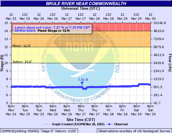
Brule River near Commonwealth
Critical Stages
10' - Action
12' - Flood
14' - Moderate
16' - Major
Latest Observation
Updated: 6:30 PM CST 12/8/25
Status: No Flooding
Stage: 6.83 ft
Flow: 0.431 kcfs
Forecast
Forecast not available for this location.
| Time | Stage (ft) | Flow (kcfs) |
|---|---|---|
| 6:30 PM 12/8 | 6.83 | 0.431 |
| 6:15 PM 12/8 | 6.83 | 0.431 |
| 6:00 PM 12/8 | 6.83 | 0.431 |
| 5:45 PM 12/8 | 6.82 | 0.427 |
| 5:30 PM 12/8 | 6.83 | 0.431 |
| 5:15 PM 12/8 | 6.83 | 0.431 |
| 5:00 PM 12/8 | 6.83 | 0.431 |
| 4:45 PM 12/8 | 6.84 | 0.434 |
| 4:30 PM 12/8 | 6.83 | 0.431 |
| 4:15 PM 12/8 | 6.84 | 0.434 |
| 4:00 PM 12/8 | 6.83 | 0.431 |
| 3:45 PM 12/8 | 6.83 | 0.431 |
| 3:30 PM 12/8 | 6.83 | 0.431 |
| 3:15 PM 12/8 | 6.83 | 0.431 |
| 3:00 PM 12/8 | 6.83 | 0.431 |
| 2:45 PM 12/8 | 6.83 | 0.431 |
| 2:30 PM 12/8 | 6.83 | 0.431 |
| 2:15 PM 12/8 | 6.83 | 0.431 |
| 2:00 PM 12/8 | 6.83 | 0.431 |
| 1:45 PM 12/8 | 6.83 | 0.431 |
| 1:30 PM 12/8 | 6.83 | 0.431 |
| 1:15 PM 12/8 | 6.84 | 0.434 |
| 1:00 PM 12/8 | 6.83 | 0.431 |
| 12:45 PM 12/8 | 6.83 | 0.431 |
| 12:30 PM 12/8 | 6.84 | 0.434 |
| 12:15 PM 12/8 | 6.83 | 0.431 |
| 12:00 PM 12/8 | 6.83 | 0.431 |
| 11:45 AM 12/8 | 6.83 | 0.431 |
| 11:30 AM 12/8 | 6.83 | 0.431 |
| 11:15 AM 12/8 | 6.84 | 0.434 |
15' -
Floodwaters are likely surrounding seasonal homes northeast of Florence.
13.5' -
Floodwaters approach seasonal homes northeast of Florence.
12' -
Flooding is mainly confined to wooded lowland areas.
10' -
There is minor flooding to wooded lowland.
| Date | Stage (ft) |
|---|---|
| Apr 17, 2002 | 15.67 |
| Apr 16, 2023 | 15.19 |
| Apr 25, 1996 | 13.91 |
| May 2, 2013 | 13.3 |
| Apr 23, 2019 | 12.45 |
| Apr 11, 2017 | 12.15 |
| Apr 21, 2004 | 12.13 |
| Apr 14, 2022 | 12.01 |
| May 1, 2020 | 11.73 |
| May 13, 2003 | 11.34 |
| Apr 8, 1997 | 11.31 |
| Apr 1, 1998 | 10.39 |
| Apr 9, 1991 | 10.22 |
| Mar 25, 2021 | 9.54 |
Data provided by the National Weather Service.