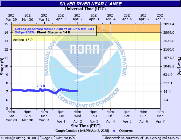
Silver River near L`Anse
Critical Stages
13' - Action
14' - Flood
17' - Moderate
19' - Major
Latest Observation
Updated: 7:15 PM EST 12/8/25
Status: No Flooding
Stage: 7.83 ft
Flow: 0.28 kcfs
Forecast
Forecast not available for this location.
| Time | Stage (ft) | Flow (kcfs) |
|---|---|---|
| 7:15 PM 12/8 | 7.83 | 0.28 |
| 7:00 PM 12/8 | 7.82 | 0.277 |
| 6:45 PM 12/8 | 7.83 | 0.28 |
| 6:30 PM 12/8 | 7.83 | 0.28 |
| 6:15 PM 12/8 | 7.84 | 0.283 |
| 6:00 PM 12/8 | 7.84 | 0.283 |
| 5:45 PM 12/8 | 7.84 | 0.283 |
| 5:30 PM 12/8 | 7.84 | 0.283 |
| 5:15 PM 12/8 | 7.84 | 0.283 |
| 5:00 PM 12/8 | 7.85 | 0.285 |
| 4:45 PM 12/8 | 7.84 | 0.283 |
| 4:30 PM 12/8 | 7.84 | 0.283 |
| 4:15 PM 12/8 | 7.85 | 0.285 |
| 4:00 PM 12/8 | 7.85 | 0.285 |
| 3:45 PM 12/8 | 7.85 | 0.285 |
| 3:30 PM 12/8 | 7.85 | 0.285 |
| 3:15 PM 12/8 | 7.85 | 0.285 |
| 3:00 PM 12/8 | 7.85 | 0.285 |
| 2:45 PM 12/8 | 7.86 | 0.288 |
| 2:30 PM 12/8 | 7.85 | 0.285 |
| 2:15 PM 12/8 | 7.86 | 0.288 |
| 2:00 PM 12/8 | 7.86 | 0.288 |
| 1:45 PM 12/8 | 7.86 | 0.288 |
| 1:30 PM 12/8 | 7.86 | 0.288 |
| 1:15 PM 12/8 | 7.86 | 0.288 |
| 1:00 PM 12/8 | 7.85 | 0.285 |
| 12:45 PM 12/8 | 7.86 | 0.288 |
| 12:30 PM 12/8 | 7.85 | 0.285 |
| 12:15 PM 12/8 | 7.85 | 0.285 |
| 12:00 PM 12/8 | 7.85 | 0.285 |
19' -
Water begins to flow over the bridge on Skanee Road
17' -
Water levels approach Skanee Road on the west side of the river
15' -
Water reaches the bottom of the bridge on Skanee Road and backwater effects begin
14' -
Flood waters may impact homes and low lying areas along the river near Skanee Road...Townline Road...and Collins Road
11' -
The river begins to overflow its natural banks and flooding of low lying wooded areas occurs
| Date | Stage (ft) |
|---|---|
| May 12, 2003 | 15.18 |
| Apr 30, 2013 | 13.09 |
| Apr 17, 2002 | 13 |
| Apr 19, 2004 | 12.57 |
| Apr 22, 2019 | 11.81 |
| Apr 12, 2023 | 11.73 |
| Aug 18, 2017 | 11.57 |
| Apr 24, 2022 | 11.29 |
| Apr 22, 2008 | 10.88 |
| Mar 9, 2016 | 10.48 |
| Apr 25, 2009 | 10.45 |
| Apr 6, 2005 | 10.4 |
| Jun 17, 2018 | 10.33 |
| Apr 13, 2015 | 10.16 |
| Mar 26, 2007 | 9.93 |
| Apr 4, 2014 | 9.81 |
| Apr 11, 2011 | 9.8 |
| Mar 18, 2012 | 9.79 |
| Mar 31, 2006 | 9.73 |
| Jun 19, 2024 | 9.63 |
Data provided by the National Weather Service.