Sturgeon River near Sidnaw
Critical Stages
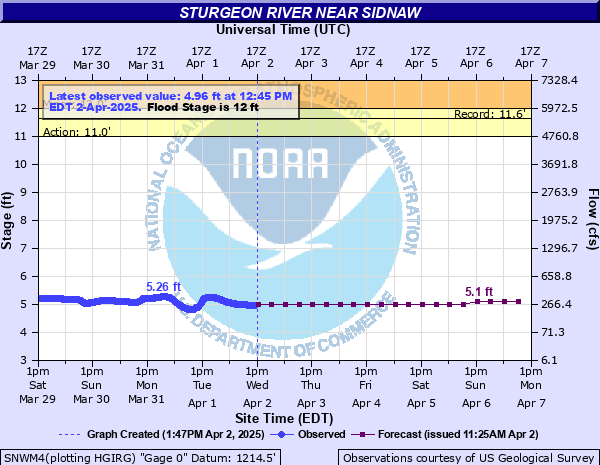
11' - Action
12' - Flood
15' - Moderate
17' - Major
Latest Observation
Updated: 7:45 PM EST 12/8/25
Status: No Flooding
Stage: 4.33 ft
Flow: 0.118 kcfs
Forecast
Forecast not available for this location.
| Time | Stage (ft) | Flow (kcfs) |
|---|---|---|
| 7:45 PM 12/8 | 4.33 | 0.118 |
| 7:30 PM 12/8 | 4.32 | 0.116 |
| 7:15 PM 12/8 | 4.31 | 0.115 |
| 7:00 PM 12/8 | 4.31 | 0.115 |
| 6:45 PM 12/8 | 4.31 | 0.115 |
| 6:30 PM 12/8 | 4.31 | 0.115 |
| 6:15 PM 12/8 | 4.3 | 0.113 |
| 6:00 PM 12/8 | 4.3 | 0.113 |
| 5:45 PM 12/8 | 4.31 | 0.115 |
| 5:30 PM 12/8 | 4.31 | 0.115 |
| 5:15 PM 12/8 | 4.31 | 0.115 |
| 5:00 PM 12/8 | 4.31 | 0.115 |
| 4:45 PM 12/8 | 4.3 | 0.113 |
| 4:30 PM 12/8 | 4.3 | 0.113 |
| 4:15 PM 12/8 | 4.3 | 0.113 |
| 4:00 PM 12/8 | 4.3 | 0.113 |
| 3:45 PM 12/8 | 4.31 | 0.115 |
| 3:30 PM 12/8 | 4.31 | 0.115 |
| 3:15 PM 12/8 | 4.31 | 0.115 |
| 3:00 PM 12/8 | 4.31 | 0.115 |
| 2:45 PM 12/8 | 4.31 | 0.115 |
| 2:30 PM 12/8 | 4.31 | 0.115 |
| 2:15 PM 12/8 | 4.32 | 0.116 |
| 2:00 PM 12/8 | 4.32 | 0.116 |
| 1:45 PM 12/8 | 4.33 | 0.118 |
| 1:30 PM 12/8 | 4.34 | 0.12 |
| 1:15 PM 12/8 | 4.34 | 0.12 |
| 1:00 PM 12/8 | 4.34 | 0.12 |
| 12:45 PM 12/8 | 4.36 | 0.123 |
| 12:30 PM 12/8 | 4.38 | 0.126 |
17.1' -
Water reaches the bottom of the Plains Road Bridge in the center
16' -
Water reaches the bottom of the Plains Road Bridge on the right bank. Backwater effects begin at this stage
12' -
Flooding of low lying wooded lands upstream and downstream occurs
8' -
The river begins to overtop its banks
| Date | Stage (ft) |
|---|---|
| Apr 24, 1960 | 11.63 |
| Apr 17, 2002 | 11.44 |
| Apr 20, 1985 | 11.07 |
| Apr 21, 1957 | 10.4 |
| Apr 30, 1951 | 10.35 |
| Jun 6, 1944 | 10.18 |
| May 7, 1943 | 10.15 |
| Apr 23, 2019 | 10.12 |
| Apr 20, 1952 | 10.03 |
| May 1, 2013 | 9.98 |
| Jul 16, 1968 | 9.76 |
| Apr 16, 1954 | 9.73 |
| Apr 20, 2004 | 9.68 |
| May 9, 1965 | 9.63 |
| Apr 16, 2023 | 9.56 |
| Apr 26, 1979 | 9.52 |
| May 10, 1950 | 9.49 |
| Apr 1, 1947 | 9.31 |
| May 7, 1949 | 9.28 |
| May 26, 1999 | 9.25 |
Data provided by the National Weather Service.