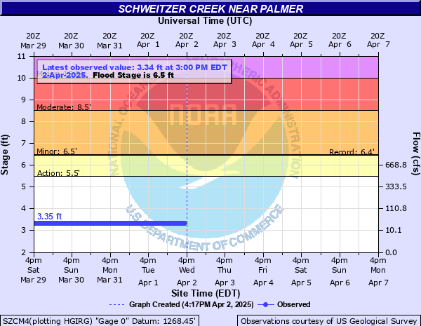
Schweitzer Creek near Palmer
Critical Stages
5.5' - Action
6.5' - Flood
8.5' - Moderate
10' - Major
Latest Observation
Updated: 8:00 PM EST 12/8/25
Status: No Flooding
Stage: 3.25 ft
Flow: 0.0059 kcfs
Forecast
Forecast not available for this location.
| Time | Stage (ft) | Flow (kcfs) |
|---|---|---|
| 8:00 PM 12/8 | 3.25 | 0.0059 |
| 7:45 PM 12/8 | 3.25 | 0.0059 |
| 7:30 PM 12/8 | 3.24 | 0.0057 |
| 7:15 PM 12/8 | 3.25 | 0.0059 |
| 7:00 PM 12/8 | 3.25 | 0.0059 |
| 6:45 PM 12/8 | 3.25 | 0.0059 |
| 6:30 PM 12/8 | 3.25 | 0.0059 |
| 6:15 PM 12/8 | 3.25 | 0.0059 |
| 6:00 PM 12/8 | 3.25 | 0.0059 |
| 5:45 PM 12/8 | 3.25 | 0.0059 |
| 5:30 PM 12/8 | 3.25 | 0.0059 |
| 5:15 PM 12/8 | 3.25 | 0.0059 |
| 5:00 PM 12/8 | 3.25 | 0.0059 |
| 4:45 PM 12/8 | 3.25 | 0.0059 |
| 4:30 PM 12/8 | 3.25 | 0.0059 |
| 4:15 PM 12/8 | 3.25 | 0.0059 |
| 4:00 PM 12/8 | 3.25 | 0.0059 |
| 3:45 PM 12/8 | 3.24 | 0.0057 |
| 3:30 PM 12/8 | 3.25 | 0.0059 |
| 3:15 PM 12/8 | 3.24 | 0.0057 |
| 3:00 PM 12/8 | 3.25 | 0.0059 |
| 2:45 PM 12/8 | 3.24 | 0.0057 |
| 2:30 PM 12/8 | 3.24 | 0.0057 |
| 2:15 PM 12/8 | 3.24 | 0.0057 |
| 2:00 PM 12/8 | 3.24 | 0.0057 |
| 1:45 PM 12/8 | 3.24 | 0.0057 |
| 1:30 PM 12/8 | 3.24 | 0.0057 |
| 1:15 PM 12/8 | 3.24 | 0.0057 |
| 1:00 PM 12/8 | 3.24 | 0.0057 |
| 12:45 PM 12/8 | 3.24 | 0.0057 |
8.5' -
Water flows over County Road PFS bridge
6.5' -
Water reaches the bottom of County Road PFS bridge
5.5' -
Water overflows the banks near bridge on County Road PFS
| Date | Stage (ft) |
|---|---|
| May 31, 1970 | 6.5 |
| Apr 20, 1985 | 6.44 |
| Sep 11, 1978 | 5.9 |
| Apr 17, 2002 | 5.85 |
| Apr 15, 2023 | 5.66 |
| Apr 14, 2022 | 5.28 |
| May 1, 2013 | 5.27 |
| Jun 7, 1997 | 5.07 |
| May 20, 2019 | 5.03 |
| May 2, 1972 | 4.96 |
| May 30, 1983 | 4.86 |
| Apr 22, 1979 | 4.85 |
| Apr 21, 1966 | 4.82 |
| Apr 26, 1996 | 4.82 |
| Apr 25, 1982 | 4.79 |
| May 8, 1965 | 4.79 |
| Apr 7, 1988 | 4.78 |
| Apr 14, 1964 | 4.76 |
| May 3, 1973 | 4.76 |
| Apr 22, 1975 | 4.74 |
Data provided by the National Weather Service.