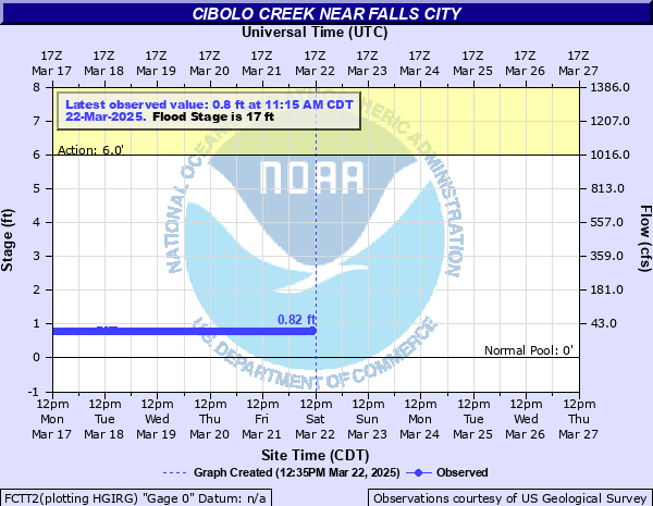
Cibolo Creek near Falls City
Critical Stages
6' - Action
17' - Flood
21' - Moderate
25' - Major
Latest Observation
Updated: 7:15 AM CST 12/6/25
Status: No Flooding
Stage: 0.83 ft
Flow: 0.032 kcfs
Forecast
Forecast not available for this location.
| Time | Stage (ft) | Flow (kcfs) |
|---|---|---|
| 7:15 AM 12/6 | 0.83 | 0.032 |
| 7:00 AM 12/6 | 0.84 | 0.0327 |
| 6:45 AM 12/6 | 0.83 | 0.032 |
| 6:30 AM 12/6 | 0.84 | 0.0327 |
| 6:15 AM 12/6 | 0.83 | 0.032 |
| 6:00 AM 12/6 | 0.84 | 0.0327 |
| 5:45 AM 12/6 | 0.84 | 0.0327 |
| 5:30 AM 12/6 | 0.83 | 0.032 |
| 5:15 AM 12/6 | 0.83 | 0.032 |
| 5:00 AM 12/6 | 0.84 | 0.0327 |
| 4:45 AM 12/6 | 0.84 | 0.0327 |
| 4:30 AM 12/6 | 0.83 | 0.032 |
| 4:15 AM 12/6 | 0.84 | 0.0327 |
| 4:00 AM 12/6 | 0.83 | 0.032 |
| 3:45 AM 12/6 | 0.84 | 0.0327 |
| 3:30 AM 12/6 | 0.84 | 0.0327 |
| 3:15 AM 12/6 | 0.84 | 0.0327 |
| 3:00 AM 12/6 | 0.83 | 0.032 |
| 2:45 AM 12/6 | 0.83 | 0.032 |
| 2:30 AM 12/6 | 0.84 | 0.0327 |
| 2:15 AM 12/6 | 0.84 | 0.0327 |
| 2:00 AM 12/6 | 0.84 | 0.0327 |
| 1:45 AM 12/6 | 0.85 | 0.0334 |
| 1:30 AM 12/6 | 0.84 | 0.0327 |
| 1:15 AM 12/6 | 0.84 | 0.0327 |
| 1:00 AM 12/6 | 0.84 | 0.0327 |
| 12:45 AM 12/6 | 0.85 | 0.0334 |
| 12:30 AM 12/6 | 0.85 | 0.0334 |
| 12:15 AM 12/6 | 0.85 | 0.0334 |
| 12:00 AM 12/6 | 0.84 | 0.0327 |
35' -
Massive crop and pastureland flooding occurs below La Vernia to the San Antonio River confluence. Livestock should be moved immediately well out of the flood plain. Lowest homes below La Vernia to the San Antonio River are threatened. Disastrous flooding downstream in Goliad State Park.
31' -
Major flooding approaches the lowest homes below Stockdale to the San Antonio River confluence. Hundreds of livestock are cut off and potentially drown. Most roads and bridges near the river flood. All the facilities in Goliad State Park downstream flood and are severely damaged.
27' -
Major lowland flooding of crop and pasture land above Stockdale to the San Antonio River confluence. Cuts off hundreds of cattle and potentially drowns them. Most roads and bridges near the river flood. Nearly all the facilities of Goliad State Park downstream flood and are severely damaged.
25' -
Major lowland flooding of crop and pasturelands cut off many livestock and potentially drown them. Widespread flooding reaches secondary and primary roads, low bridges and crossings. Most of the Goliad State Park facilities downstream are under water.
21' -
Livestock are cut off and potentially drowned in low areas below Stockdale to below Panna Maria. Lower areas of Goliad State Park downstream flood.
17' -
Minor lowland flooding of crop and pastureland damages irrigation pumps and any equipment near the channel. Livestock are cut off in low areas.
| Date | Stage (ft) |
|---|---|
| Oct 19, 1998 | 39.86 |
| Sep 28, 1973 | 35.44 |
| Jan 1, 1913 | 35 |
| Jul 6, 1942 | 34.45 |
| Nov 23, 2004 | 34.01 |
| Sep 22, 1967 | 33.39 |
| Aug 29, 1946 | 32.85 |
| May 17, 1992 | 32.34 |
| Jun 14, 1935 | 32 |
| Jun 27, 1993 | 31.34 |
| Sep 9, 1942 | 30.95 |
| Dec 23, 1991 | 30.66 |
| Jul 4, 2002 | 30.13 |
| Jun 24, 1997 | 28.4 |
| Jan 21, 1968 | 28.13 |
| Sep 11, 1952 | 27.93 |
| Jul 18, 1973 | 27.2 |
| Jun 4, 1987 | 26.94 |
| Mar 14, 2007 | 26.26 |
| Mar 14, 2007 | 26.26 |
Data provided by the National Weather Service.