« Back to Brockway Township Rivers
Cass River at Vassar
Critical Stages
12' - Action
14' - Flood
15' - Moderate
18' - Major
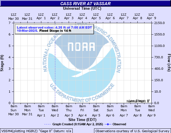
Latest Observation
Updated: 7:03 PM LMT 12/31/00
Status: Obs Not Current
Stage: -999 ft
Flow: -999 kcfs
Forecast
Forecast not available for this location.
Observation history not available.
24.8' -
All of downtown Vassar floods. Most businesses and about 50 homes flood. The flood waters reach the intersection of Main and Huron Streets on the northwest side of the downtown area, and the intersection of Huron and East Streets on the southeast side. One story homes on Cass Avenue along the river may flood up to the eaves.
17.7' -
Many businesses and homes flood with considerable damage. Some homes flood with up to 2 feet of water. Back water from the Moore drain could cause flooding to reach up to 4 feet deep in some businesses. The river also begins touching the bottom of the M-15 bridge.
17' -
East Huron Street begins to flood near the bridge in Vassar.
15' -
Some homes begin to flood.
14' -
Some basements of businesses near the river begin to flood. Water Street in Vassar will be flooded up to a foot.
12' -
Some overflow along the banks begins.
| Date | Stage (ft) |
|---|---|
| Sep 12, 1986 | 24.82 |
| Mar 20, 1948 | 20.8 |
| Mar 18, 1942 | 19 |
| Mar 30, 1916 | 18.9 |
| Apr 6, 1929 | 18.5 |
| May 22, 1996 | 18.5 |
| Jun 22, 1996 | 18.2 |
| Feb 22, 1997 | 18.2 |
| Mar 6, 1976 | 17.7 |
| Feb 13, 2009 | 17.27 |
| Feb 3, 1968 | 16.98 |
| Feb 7, 1938 | 16.8 |
| Apr 1, 1960 | 16.7 |
| Mar 29, 1967 | 16.26 |
| Mar 7, 2004 | 16 |
| Jul 8, 1994 | 15.8 |
| Mar 5, 1974 | 15.74 |
| Apr 13, 2013 | 15.3 |
| May 18, 1923 | 15.2 |
| Jun 19, 1996 | 15.1 |
Data provided by the National Weather Service.