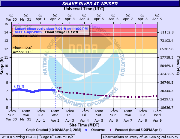
Snake River at Weiser
Critical Stages
11.5' - Action
12' - Flood
13.5' - Moderate
14.5' - Major
Latest Observation
Updated: 6:00 AM MST 12/16/25
Status: No Flooding
Stage: 3.32 ft
Flow: 10.1 kcfs
Forecast
| Time | Stage (ft) | Flow (kcfs) |
|---|---|---|
| 11 AM 12/16 | 3.27 | 9.91 |
| 5 PM 12/16 | 3.26 | 9.87 |
| 11 PM 12/16 | 3.26 | 9.87 |
| 5 AM 12/17 | 3.25 | 9.82 |
| 11 AM 12/17 | 3.25 | 9.82 |
| 5 PM 12/17 | 3.27 | 9.91 |
| 11 PM 12/17 | 3.3 | 10.1 |
| 5 AM 12/18 | 3.36 | 10.3 |
| 11 AM 12/18 | 3.42 | 10.6 |
| 5 PM 12/18 | 3.45 | 10.8 |
| 11 PM 12/18 | 3.46 | 10.8 |
| 5 AM 12/19 | 3.51 | 11 |
| 11 AM 12/19 | 3.62 | 11.6 |
| 5 PM 12/19 | 3.72 | 12 |
| 11 PM 12/19 | 3.79 | 12.4 |
| 5 AM 12/20 | 3.85 | 12.7 |
| 11 AM 12/20 | 3.88 | 12.8 |
| 5 PM 12/20 | 3.89 | 12.9 |
| 11 PM 12/20 | 3.87 | 12.8 |
| 5 AM 12/21 | 3.83 | 12.6 |
| 11 AM 12/21 | 3.77 | 12.3 |
| 5 PM 12/21 | 3.7 | 11.9 |
| 11 PM 12/21 | 3.63 | 11.6 |
| 5 AM 12/22 | 3.58 | 11.4 |
| 11 AM 12/22 | 3.56 | 11.3 |
| 5 PM 12/22 | 3.55 | 11.2 |
| 11 PM 12/22 | 3.55 | 11.2 |
| 5 AM 12/23 | 3.55 | 11.2 |
| 11 AM 12/23 | 3.56 | 11.3 |
| 5 PM 12/23 | 3.58 | 11.4 |
| 11 PM 12/23 | 3.6 | 11.5 |
| 5 AM 12/24 | 3.61 | 11.5 |
| 11 AM 12/24 | 3.61 | 11.5 |
| 5 PM 12/24 | 3.62 | 11.6 |
| 11 PM 12/24 | 3.64 | 11.7 |
| 5 AM 12/25 | 3.69 | 11.9 |
| Time | Stage (ft) | Flow (kcfs) |
|---|---|---|
| 6:00 AM 12/16 | 3.32 | 10.1 |
| 5:45 AM 12/16 | 3.32 | 10.1 |
| 5:30 AM 12/16 | 3.32 | 10.1 |
| 5:15 AM 12/16 | 3.32 | 10.1 |
| 5:00 AM 12/16 | 3.32 | 10.1 |
| 4:45 AM 12/16 | 3.32 | 10.1 |
| 4:30 AM 12/16 | 3.32 | 10.1 |
| 4:15 AM 12/16 | 3.32 | 10.1 |
| 4:00 AM 12/16 | 3.32 | 10.1 |
| 3:45 AM 12/16 | 3.32 | 10.1 |
| 3:30 AM 12/16 | 3.32 | 10.1 |
| 3:15 AM 12/16 | 3.32 | 10.1 |
| 3:00 AM 12/16 | 3.33 | 10.2 |
| 2:45 AM 12/16 | 3.32 | 10.1 |
| 2:30 AM 12/16 | 3.32 | 10.1 |
| 2:15 AM 12/16 | 3.33 | 10.2 |
| 2:00 AM 12/16 | 3.32 | 10.1 |
| 1:45 AM 12/16 | 3.32 | 10.1 |
| 1:30 AM 12/16 | 3.32 | 10.1 |
| 1:15 AM 12/16 | 3.32 | 10.1 |
| 1:00 AM 12/16 | 3.32 | 10.1 |
| 12:45 AM 12/16 | 3.32 | 10.1 |
| 12:30 AM 12/16 | 3.32 | 10.1 |
| 12:15 AM 12/16 | 3.32 | 10.1 |
| 12:00 AM 12/16 | 3.33 | 10.2 |
| 11:45 PM 12/15 | 3.33 | 10.2 |
| 11:30 PM 12/15 | 3.32 | 10.1 |
| 11:15 PM 12/15 | 3.32 | 10.1 |
| 11:00 PM 12/15 | 3.33 | 10.2 |
| 10:45 PM 12/15 | 3.33 | 10.2 |
15' -
Major flooding will occur near the river, with extensive flooding of agricultural land in Malheur County, Oregon with several county roads underwater. Significant flooding will also occur in Weiser, Idaho with floodwater covering the water treatment plant on Mortimer Road. Floodwater may also reach the airport south of Weiser.
13.5' -
Moderate flooding is likely near Weiser with water overtopping Mortimer Road to a depth of two feet. Flooding of the Weiser Water Treatment Plant is possible. Some county roads in Malheur County near the river will have water flowing over them. Moderate flooding of agricultural land will occur near the river in Malheur County.
12' -
Flooding of agricultural land near the river is likely in Malheur County, Oregon and in Washington County, Idaho. Mortimer Road in Weiser will be flooded.
| Date | Stage (ft) |
|---|---|
| Dec 20, 1972 | 15.55 |
| Jan 14, 1979 | 15.54 |
| Feb 17, 1933 | 15 |
| Apr 29, 1952 | 14.67 |
| Jan 3, 1997 | 14.47 |
| Jan 13, 1974 | 14.46 |
| Apr 20, 1984 | 13.66 |
| May 23, 1921 | 13.6 |
| Feb 25, 1986 | 13.5 |
| Apr 21, 1943 | 12.76 |
| Dec 25, 1964 | 12.62 |
| May 24, 1957 | 12.61 |
| Mar 21, 2017 | 12.53 |
| May 12, 1984 | 12.5 |
| Mar 10, 1986 | 12.5 |
| Feb 4, 1982 | 12.32 |
| May 3, 1938 | 12.25 |
| Apr 24, 2006 | 11.95 |
| Jan 29, 1922 | 11.63 |
| May 16, 2011 | 11.57 |
Data provided by the National Weather Service.