« Back to Cambridge Municipal Rivers
Snake River (MN) near Pine City
Critical Stages
8' - Action
9' - Flood
10' - Moderate
11' - Major
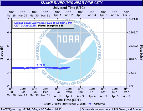
Latest Observation
Updated: 2:00 PM CST 12/8/25
Status: No Flooding
Stage: 2.89 ft
Flow: 0.131 kcfs
Forecast
Forecast not available for this location.
| Time | Stage (ft) | Flow (kcfs) |
|---|---|---|
| 2:00 PM 12/8 | 2.89 | 0.131 |
| 1:45 PM 12/8 | 2.89 | 0.131 |
| 1:30 PM 12/8 | 2.89 | 0.131 |
| 1:15 PM 12/8 | 2.9 | 0.135 |
| 1:00 PM 12/8 | 2.9 | 0.135 |
| 12:45 PM 12/8 | 2.89 | 0.131 |
| 12:30 PM 12/8 | 2.9 | 0.135 |
| 12:15 PM 12/8 | 2.89 | 0.131 |
| 12:00 PM 12/8 | 2.88 | 0.128 |
| 11:45 AM 12/8 | 2.9 | 0.135 |
| 11:30 AM 12/8 | 2.9 | 0.135 |
| 11:15 AM 12/8 | 2.88 | 0.128 |
| 11:00 AM 12/8 | 2.9 | 0.135 |
| 10:45 AM 12/8 | 2.89 | 0.131 |
| 10:30 AM 12/8 | 2.89 | 0.131 |
| 10:15 AM 12/8 | 2.89 | 0.131 |
| 10:00 AM 12/8 | 2.89 | 0.131 |
| 9:45 AM 12/8 | 2.88 | 0.128 |
| 9:30 AM 12/8 | 2.9 | 0.135 |
| 9:15 AM 12/8 | 2.89 | 0.131 |
| 9:00 AM 12/8 | 2.88 | 0.128 |
| 8:45 AM 12/8 | 2.9 | 0.135 |
| 8:30 AM 12/8 | 2.89 | 0.131 |
| 8:15 AM 12/8 | 2.89 | 0.131 |
| 8:00 AM 12/8 | 2.9 | 0.135 |
| 7:45 AM 12/8 | 2.89 | 0.131 |
| 7:30 AM 12/8 | 2.89 | 0.131 |
| 7:15 AM 12/8 | 2.9 | 0.135 |
| 7:00 AM 12/8 | 2.89 | 0.131 |
| 6:45 AM 12/8 | 2.89 | 0.131 |
9' -
This will cause flooding near Cross Lake near Pine City.
8.5' -
A few of the lowest dwellings adjacent to the Snake River, Cross Lake and Pokegama Lake need protection from flood waters.
8' -
Water encroaches on the lowest homes along the shoreline. Backwater from the Snake River will cause minor flooding of lowland areas adjacent to Cross Lake, Pokegama Lake and the Snake River.
7' -
High water begins impacting low lying agricultural areas near the Snake River.
6.5' -
Snake River is out of its banks at this level. Boat landing in Pine City inundated.
| Date | Stage (ft) |
|---|---|
| Jul 27, 1972 | 10.38 |
| May 9, 1950 | 9.8 |
| Apr 18, 1965 | 9.56 |
| Apr 18, 2023 | 9.36 |
| Apr 27, 2001 | 9.23 |
| Apr 12, 1969 | 9.08 |
| Apr 9, 1997 | 8.89 |
| Jul 17, 2016 | 8.82 |
| May 2, 1975 | 8.56 |
| May 17, 2022 | 8.34 |
| Apr 6, 1986 | 8.33 |
| Apr 12, 1952 | 8.3 |
| Jul 17, 2018 | 8.22 |
| Jun 15, 1984 | 8.22 |
| May 4, 1954 | 8.13 |
| May 28, 1962 | 8.11 |
| Jun 20, 1967 | 8.1 |
| Apr 9, 1956 | 8.09 |
| May 14, 1979 | 8.02 |
| Jun 1, 2012 | 7.93 |
Data provided by the National Weather Service.