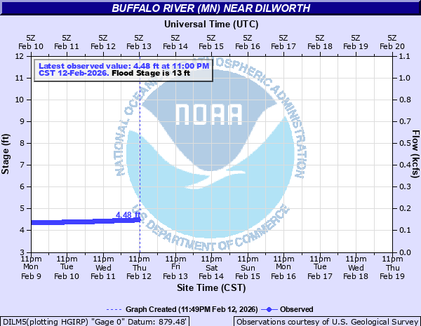
Buffalo River (MN) near Dilworth
Critical Stages
12' - Action
13' - Flood
20' - Moderate
26' - Major
Latest Observation
Updated: 9:00 AM CST 12/6/25
Status: No Flooding
Stage: 3.71 ft
Flow: 0.0676 kcfs
Forecast
Forecast not available for this location.
| Time | Stage (ft) | Flow (kcfs) |
|---|---|---|
| 9:00 AM 12/6 | 3.71 | 0.0676 |
| 8:45 AM 12/6 | 3.71 | 0.0676 |
| 8:30 AM 12/6 | 3.71 | 0.0676 |
| 8:15 AM 12/6 | 3.71 | 0.0676 |
| 8:00 AM 12/6 | 3.71 | 0.0676 |
| 7:45 AM 12/6 | 3.71 | 0.0676 |
| 7:30 AM 12/6 | 3.71 | 0.0676 |
| 7:15 AM 12/6 | 3.71 | 0.0676 |
| 7:00 AM 12/6 | 3.71 | 0.0676 |
| 6:45 AM 12/6 | 3.7 | 0.067 |
| 6:30 AM 12/6 | 3.71 | 0.0676 |
| 6:15 AM 12/6 | 3.7 | 0.067 |
| 6:00 AM 12/6 | 3.7 | 0.067 |
| 5:45 AM 12/6 | 3.7 | 0.067 |
| 5:30 AM 12/6 | 3.7 | 0.067 |
| 5:15 AM 12/6 | 3.7 | 0.067 |
| 5:00 AM 12/6 | 3.7 | 0.067 |
| 4:45 AM 12/6 | 3.7 | 0.067 |
| 4:30 AM 12/6 | 3.7 | 0.067 |
| 4:15 AM 12/6 | 3.7 | 0.067 |
| 4:00 AM 12/6 | 3.7 | 0.067 |
| 3:45 AM 12/6 | 3.7 | 0.067 |
| 3:30 AM 12/6 | 3.7 | 0.067 |
| 3:15 AM 12/6 | 3.7 | 0.067 |
| 3:00 AM 12/6 | 3.7 | 0.067 |
| 2:45 AM 12/6 | 3.7 | 0.067 |
| 2:30 AM 12/6 | 3.7 | 0.067 |
| 2:15 AM 12/6 | 3.7 | 0.067 |
| 2:00 AM 12/6 | 3.7 | 0.067 |
| 1:45 AM 12/6 | 3.7 | 0.067 |
26' -
MAJOR FLOOD STAGE.
25' -
US Highway 10 east of Glyndon is flooded. Extensive flooding to agricultural areas.
22' -
The approach road on the north side of the bridge begins to flood.
20' -
MODERATE FLOOD STAGE.
17' -
Some agricultural flooding begins.
15.8' -
Road west of gage begins to flood.
15' -
Gage not accessible above 15 feet.
14.9' -
Bottom of steel bridge causes upstream road to flood.
13' -
MINOR FLOOD STAGE.
12' -
ACTION STAGE/FORECAST SERVICE STAGE.
| Date | Stage (ft) |
|---|---|
| Jul 2, 1975 | 27.1 |
| Apr 6, 1997 | 27.02 |
| Mar 25, 2009 | 25.86 |
| Apr 11, 1969 | 25.55 |
| Apr 16, 2023 | 24.43 |
| Apr 1, 2006 | 24.11 |
| Jun 11, 1962 | 23.56 |
| Apr 11, 1965 | 23.37 |
| Mar 18, 1966 | 23.31 |
| Apr 10, 2001 | 23.29 |
| Apr 3, 2019 | 23.08 |
| Apr 6, 2011 | 22.89 |
| Jul 20, 1993 | 22.88 |
| Apr 6, 1989 | 22.8 |
| Mar 31, 1978 | 22.76 |
| Apr 2, 1943 | 22.6 |
| Mar 31, 2020 | 22.05 |
| May 19, 1998 | 21.77 |
| Jun 23, 2000 | 21.67 |
| Apr 16, 1979 | 21.6 |
Data provided by the National Weather Service.