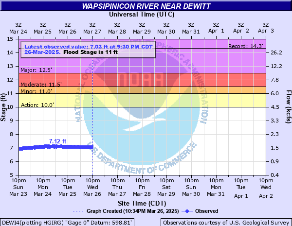
Wapsipinicon River near DeWitt
Critical Stages
10' - Action
11' - Flood
11.5' - Moderate
12.5' - Major
Latest Observation
Updated: 4:30 PM CST 12/15/25
Status: No Flooding
Stage: 6.18 ft
Flow: 0.934 kcfs
Forecast
Forecast not available for this location.
| Time | Stage (ft) | Flow (kcfs) |
|---|---|---|
| 5:30 PM 12/15 | 6.16 | 0.923 |
| 5:15 PM 12/15 | 6.16 | 0.923 |
| 5:00 PM 12/15 | 6.16 | 0.923 |
| 4:45 PM 12/15 | 6.17 | 0.928 |
| 4:30 PM 12/15 | 6.18 | 0.934 |
| 4:15 PM 12/15 | 6.18 | 0.934 |
| 4:00 PM 12/15 | 6.2 | 0.945 |
| 3:45 PM 12/15 | 6.21 | 0.951 |
| 3:30 PM 12/15 | 6.22 | 0.956 |
| 3:15 PM 12/15 | 6.23 | 0.962 |
| 3:00 PM 12/15 | 6.25 | 0.973 |
| 2:45 PM 12/15 | 6.27 | 0.985 |
| 2:30 PM 12/15 | 6.28 | 0.99 |
| 2:15 PM 12/15 | 6.3 | 1 |
| 2:00 PM 12/15 | 6.31 | 1.01 |
| 1:45 PM 12/15 | 6.33 | 1.02 |
| 1:30 PM 12/15 | 6.33 | 1.02 |
| 1:15 PM 12/15 | 6.35 | 1.03 |
| 1:00 PM 12/15 | 6.36 | 1.04 |
| 12:45 PM 12/15 | 6.37 | 1.04 |
| 12:30 PM 12/15 | 6.38 | 1.05 |
| 12:15 PM 12/15 | 6.39 | 1.06 |
| 12:00 PM 12/15 | 6.39 | 1.06 |
| 11:45 AM 12/15 | 6.4 | 1.06 |
| 11:30 AM 12/15 | 6.41 | 1.07 |
| 11:15 AM 12/15 | 6.41 | 1.07 |
| 11:00 AM 12/15 | 6.41 | 1.07 |
| 10:45 AM 12/15 | 6.41 | 1.07 |
| 10:30 AM 12/15 | 6.42 | 1.07 |
| 10:15 AM 12/15 | 6.42 | 1.07 |
16.5' -
Water affects the lowest sections of U.S. Highway 61 near the river and reaches the lowest sections of the County Road Y52 bridge deck.
16' -
Water reaches the bottom of the U.S. Highway 67 bridge deck near Folletts and reaches the bottom of the County Road E63/Y22 bridge deck near Toronto.
15.5' -
Water reaches the bottom of the County Road Z30 bridge deck. Water reaches the bottom of the Iowa Highway 956 bridge deck.
15' -
Water reaches the bottom of the U.S. Highway 30 bridge deck and affects the lowest sections of U.S. Highway 30 between Wheatland and Calamus.
14.5' -
Water affects U.S. Highway 67 near Folletts and affects the lowest sections of County Road Z30 near McCausland. Water also affects the lowest sections of County Road Y52 near the river and affects access roads to Buena Vista.
14' -
Water reaches the bottoms of the U.S. Highway 67 bridge decks over the Wapsipinicon backwaters. Water also overtops the floodwall to an establishment near the old U.S. Highway 61 bridge.
13' -
Water affects many residences along the river.
12.5' -
Major Flood Stage. Water affects old U.S. Highway 61 near the river.
12' -
Overbank flooding occurs. Water affects residences along the river between Wheatland and Calamus. Water affects businesses along the river near Calamus.
11.5' -
Moderate Flood Stage. Water affects homes along old U.S. Highway 61.
11' -
Flood Stage. Water affects County Road E63 north of the river near Toronto and affects the lowest roads in Buena Vista.
10' -
Water affects a few residences along the river.
9.5' -
Water affects Walnut Grove Park in Toronto.
| Date | Stage (ft) |
|---|---|
| Jul 2, 2014 | 14.32 |
| Jun 17, 1990 | 14.19 |
| Jun 16, 2008 | 14.13 |
| Sep 10, 2018 | 13.97 |
| Oct 7, 2018 | 13.92 |
| Oct 1, 2016 | 13.86 |
| Sep 30, 2016 | 13.86 |
| May 30, 2004 | 13.79 |
| Apr 19, 2013 | 13.7 |
| May 30, 2019 | 13.68 |
| May 24, 1999 | 13.66 |
| Jul 30, 2010 | 13.52 |
| Jun 4, 2013 | 13.46 |
| Jun 2, 2024 | 13.46 |
| Jun 30, 2013 | 13.44 |
| May 1, 2008 | 13.26 |
| Mar 14, 2019 | 13.16 |
| Jun 8, 2002 | 13.16 |
| Aug 29, 2009 | 13.14 |
| Mar 12, 2013 | 13.14 |
Data provided by the National Weather Service.