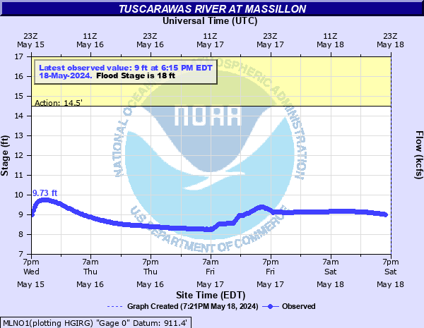
Tuscarawas River at Massillon
Critical Stages
14.5' - Action
18' - Flood
20' - Moderate
23' - Major
Latest Observation
Updated: 1:15 AM EST 12/10/25
Status: No Flooding
Stage: 7.37 ft
Flow: 0.0695 kcfs
Forecast
Forecast not available for this location.
| Time | Stage (ft) | Flow (kcfs) |
|---|---|---|
| 1:15 AM 12/10 | 7.37 | 0.0695 |
| 1:00 AM 12/10 | 7.38 | 0.0702 |
| 12:45 AM 12/10 | 7.38 | 0.0702 |
| 12:30 AM 12/10 | 7.38 | 0.0702 |
| 12:15 AM 12/10 | 7.37 | 0.0695 |
| 12:00 AM 12/10 | 7.36 | 0.0689 |
| 11:45 PM 12/9 | 7.37 | 0.0695 |
| 11:30 PM 12/9 | 7.37 | 0.0695 |
| 11:15 PM 12/9 | 7.37 | 0.0695 |
| 11:00 PM 12/9 | 7.36 | 0.0689 |
| 10:45 PM 12/9 | 7.36 | 0.0689 |
| 10:30 PM 12/9 | 7.36 | 0.0689 |
| 10:15 PM 12/9 | 7.36 | 0.0689 |
| 10:00 PM 12/9 | 7.36 | 0.0689 |
| 9:45 PM 12/9 | 7.35 | 0.0683 |
| 9:30 PM 12/9 | 7.36 | 0.0689 |
| 9:15 PM 12/9 | 7.36 | 0.0689 |
| 9:00 PM 12/9 | 7.35 | 0.0683 |
| 8:45 PM 12/9 | 7.36 | 0.0689 |
| 8:30 PM 12/9 | 7.36 | 0.0689 |
| 8:15 PM 12/9 | 7.36 | 0.0689 |
| 8:00 PM 12/9 | 7.36 | 0.0689 |
| 7:45 PM 12/9 | 7.36 | 0.0689 |
| 7:30 PM 12/9 | 7.36 | 0.0689 |
| 7:15 PM 12/9 | 7.36 | 0.0689 |
| 7:00 PM 12/9 | 7.35 | 0.0683 |
| 6:45 PM 12/9 | 7.34 | 0.0678 |
| 6:30 PM 12/9 | 7.35 | 0.0683 |
| 6:15 PM 12/9 | 7.35 | 0.0683 |
| 6:00 PM 12/9 | 7.36 | 0.0689 |
24' -
FEMA 0.2 percent flood level. Flood waters will spread onto Third Street.
23' -
Properties on Ohio Street Southwest in Navarre flooded. Numerous roads between Canal Fulton and Navarre flooded including Route 21 and 62.
22' -
FEMA 1 percent flood level. Significant flooding can be expected in many unprotected areas along the river.
21' -
Flooding along the Tuscarawas River near Massillon will be confined to areas north of the levee protection in part due to backwater from Newman Creek. Portions of Route 21 and 62 flooded.
19' -
U.S. Route 62 near Navarre inundated.
18' -
Flooding begins in the Agathon Park area to Route 21. Water encroaches on Route 62 in Navarre. Flood waters may force the closing of two railroad crossings in Massillon.
16' -
Community Park in Canal Fulton flooding. In Massillon, backwater possible along Newman and Plum Creeks. This could lead to minor road flooding along Lever Raod, High Street, Cherry Street, and First Street Northwest.
14.5' -
Pumping stations along the levee system utlized.
| Date | Stage (ft) |
|---|---|
| Feb 18, 2022 | 18.64 |
Data provided by the National Weather Service.