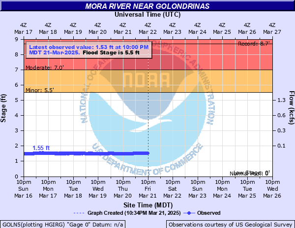
Mora River near Golondrinas
Critical Stages
5.5' - Action
5.5' - Flood
7' - Moderate
11.5' - Major
Latest Observation
Updated: 1:00 AM MST 12/16/25
Status: No Flooding
Stage: 1.52 ft
Flow: 0.0255 kcfs
Forecast
Forecast not available for this location.
| Time | Stage (ft) | Flow (kcfs) |
|---|---|---|
| 1:00 AM 12/16 | 1.52 | 0.0255 |
| 12:45 AM 12/16 | 1.52 | 0.0255 |
| 12:30 AM 12/16 | 1.51 | 0.0246 |
| 12:15 AM 12/16 | 1.52 | 0.0255 |
| 12:00 AM 12/16 | 1.51 | 0.0246 |
| 11:45 PM 12/15 | 1.51 | 0.0246 |
| 11:30 PM 12/15 | 1.51 | 0.0246 |
| 11:15 PM 12/15 | 1.51 | 0.0246 |
| 11:00 PM 12/15 | 1.51 | 0.0246 |
| 10:45 PM 12/15 | 1.51 | 0.0246 |
| 10:30 PM 12/15 | 1.51 | 0.0246 |
| 10:15 PM 12/15 | 1.51 | 0.0246 |
| 10:00 PM 12/15 | 1.51 | 0.0246 |
| 9:45 PM 12/15 | 1.51 | 0.0246 |
| 9:30 PM 12/15 | 1.51 | 0.0246 |
| 9:15 PM 12/15 | 1.51 | 0.0246 |
| 9:00 PM 12/15 | 1.51 | 0.0246 |
| 8:45 PM 12/15 | 1.51 | 0.0246 |
| 8:30 PM 12/15 | 1.51 | 0.0246 |
| 8:15 PM 12/15 | 1.51 | 0.0246 |
| 8:00 PM 12/15 | 1.51 | 0.0246 |
| 7:45 PM 12/15 | 1.51 | 0.0246 |
| 7:30 PM 12/15 | 1.51 | 0.0246 |
| 7:15 PM 12/15 | 1.51 | 0.0246 |
| 7:00 PM 12/15 | 1.51 | 0.0246 |
| 6:45 PM 12/15 | 1.51 | 0.0246 |
| 6:30 PM 12/15 | 1.51 | 0.0246 |
| 6:15 PM 12/15 | 1.51 | 0.0246 |
| 6:00 PM 12/15 | 1.51 | 0.0246 |
| 5:45 PM 12/15 | 1.51 | 0.0246 |
11.5' -
Greatest flooding since at least 1913 is now occurring. Bridges and nearby roads are inundated and likely impassable.
7' -
Pasture and range land continues to become inundated. Privately built river crossings may become unsafe due to the high water levels and fast flow.
5.5' -
Water has overflowed its natural banks and is inundating low lying areas. The inundated areas are mostly pasture and range land. No structures are yet threatened.
| Date | Stage (ft) |
|---|---|
| Aug 22, 1952 | 8.7 |
| Sep 1, 1953 | 6.1 |
| May 19, 1994 | 5.82 |
| Apr 23, 1942 | 5.35 |
| Jul 1, 1969 | 4.85 |
| Aug 10, 1979 | 4.75 |
| Jun 15, 1965 | 4.44 |
| Jun 18, 1949 | 4.42 |
| Sep 12, 2009 | 4.37 |
| Aug 18, 1961 | 4.3 |
| Apr 30, 1999 | 4.16 |
| Jun 19, 1995 | 3.94 |
Data provided by the National Weather Service.