« Back to Chenango Lake Rivers
Susquehanna River at Bainbridge
Critical Stages
13' - Action
15' - Flood
20' - Moderate
22' - Major
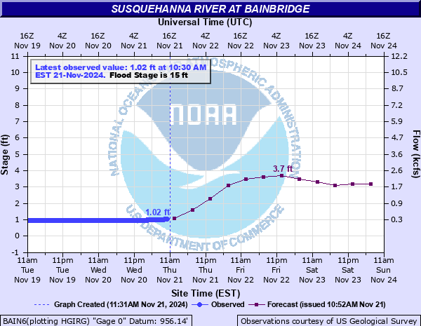
Latest Observation
Updated: 10:30 AM EST 12/11/25
Status: No Flooding
Stage: 3.7 ft
Flow: 2.31 kcfs
Forecast
| Time | Stage (ft) | Flow (kcfs) |
|---|---|---|
| 1 PM 12/11 | 2.4 | 1.2 |
| 7 PM 12/11 | 2.2 | 1.05 |
| 1 AM 12/12 | 2.1 | 0.98 |
| 7 AM 12/12 | 2.1 | 0.98 |
| 1 PM 12/12 | 2.1 | 0.98 |
| 7 PM 12/12 | 2.1 | 0.98 |
| 1 AM 12/13 | 2.1 | 0.98 |
| 7 AM 12/13 | 2.1 | 0.98 |
| 1 PM 12/13 | 2.1 | 0.98 |
| 7 PM 12/13 | 2 | 0.908 |
| 1 AM 12/14 | 2 | 0.908 |
| 7 AM 12/14 | 2 | 0.908 |
| Time | Stage (ft) | Flow (kcfs) |
|---|---|---|
| 10:30 AM 12/11 | 3.7 | 2.31 |
| 10:15 AM 12/11 | 3.69 | 2.3 |
| 10:00 AM 12/11 | 3.69 | 2.3 |
| 9:45 AM 12/11 | 3.69 | 2.3 |
| 9:30 AM 12/11 | 3.69 | 2.3 |
| 9:15 AM 12/11 | 3.7 | 2.31 |
| 9:00 AM 12/11 | 3.7 | 2.31 |
| 8:45 AM 12/11 | 3.71 | 2.32 |
| 8:30 AM 12/11 | 3.72 | 2.33 |
| 8:15 AM 12/11 | 3.74 | 2.35 |
| 8:00 AM 12/11 | 3.75 | 2.36 |
| 7:45 AM 12/11 | 3.78 | 2.39 |
| 7:30 AM 12/11 | 3.79 | 2.4 |
| 7:15 AM 12/11 | 3.82 | 2.43 |
| 7:00 AM 12/11 | 3.83 | 2.44 |
| 6:45 AM 12/11 | 3.85 | 2.45 |
| 6:30 AM 12/11 | 3.87 | 2.47 |
| 6:17 AM 12/11 | 3.88 | 2.48 |
| 6:15 AM 12/11 | 3.88 | 2.48 |
| 6:12 AM 12/11 | 3.9 | 2.5 |
| 6:07 AM 12/11 | 3.91 | 2.51 |
| 6:00 AM 12/11 | 3.9 | 2.5 |
| 5:45 AM 12/11 | 3.91 | 2.51 |
| 5:30 AM 12/11 | 3.92 | 2.52 |
| 5:15 AM 12/11 | 3.93 | 2.53 |
| 5:00 AM 12/11 | 3.95 | 2.55 |
| 4:45 AM 12/11 | 3.96 | 2.56 |
| 4:30 AM 12/11 | 3.97 | 2.57 |
| 4:15 AM 12/11 | 3.98 | 2.58 |
| 4:00 AM 12/11 | 3.98 | 2.58 |
27.05' -
This was the record flood of June 2006. Flooding was widespread and severe in Sidney and Bainbridge.
26.5' -
The East-West Main Street intersection and Press Building in Sidney begins to flood.
26.2' -
Widespread severe flood damage caused by the September 2011 flood.
26' -
The water treatment building and Grand Street in Sidney are inundated.
25' -
Flood waters spread to Clinton Street, Grand Street, Avery Street, Liberty Street and Pleasant Street in Sidney. The Sidney central fire station takes on water.
24' -
River Street and portions of East Main, and North Main Street in Bainbridge flood. Severe flooding occurs in Sidney. Sherman Avenue, Bridge Street, Willow Street and Cross Street flood. Scoville-Meno car dealership is impacted by flood waters.
23' -
Portions of Route 7 between County Route 38 and Dingman Hill Road near Bainbridge are flooded. Flood waters reach the American Legion and inundate Adams, Gilbert, Weir and Union Streets in Sidney.
22' -
Major Flood Stage. Flooding inundates County Route 39, Walnut Street, Front Street, and Oak Avenue in Bainbridge.
21' -
Water floods the westbound entrance ramp of I-88 at Bainbridge. Camp Street and Gilbert Street in Sidney are flooded.
20' -
Moderate Flood Stage. Water is 2 to 3 feet deep on Willow Street Extension in Sidney. Flood waters reach Camp Street, Winegard Street and Maple Avenue in sidney. The NYSEG substation and telephone buildings flood.
19' -
Flooding develops near Front Street and Walnut Avenue in Bainbridge. Street level to first floor flooding occurs on Railroad Avenue, Colgrove Street and lower portions of River Street in Sidney.
18.5' -
Minor flooding begins to impact the ball fields, trails and buildings on Willow Street Extension in Sidney.
17' -
Flooding occurs in the low lying areas across the river from Bainbridge.
15' -
Minor flooding occurs in fields and low lands near the river from Sidney to Bainbridge.
| Date | Stage (ft) |
|---|---|
| Jun 29, 2006 | 27.05 |
| Sep 8, 2011 | 26.2 |
| Mar 29, 1914 | 23.1 |
| Mar 15, 1977 | 22.2 |
| Mar 1, 1910 | 22.1 |
| Mar 7, 1979 | 21.96 |
| Jan 20, 1996 | 21.04 |
| Apr 4, 2005 | 20.47 |
| Oct 18, 1977 | 20.4 |
| Feb 21, 1918 | 20.4 |
| Mar 31, 1993 | 20.17 |
| Jan 10, 1998 | 19.91 |
| Mar 16, 1986 | 19.8 |
| Feb 29, 2000 | 19.53 |
| Feb 10, 1988 | 17.85 |
| Dec 14, 1983 | 17.8 |
| Mar 22, 2003 | 17.63 |
| Apr 11, 2001 | 17.55 |
| Apr 8, 2017 | 17.36 |
| Dec 3, 1996 | 16.92 |
Data provided by the National Weather Service.