« Back to Chenango Lake Rivers
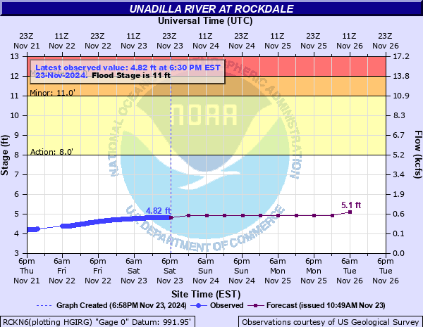
Unadilla River at Rockdale
Critical Stages
8' - Action
11' - Flood
12' - Moderate
13' - Major
Latest Observation
Updated: 10:30 AM EST 12/11/25
Status: No Flooding
Stage: 4.81 ft
Flow: 0.463 kcfs
Forecast
| Time | Stage (ft) | Flow (kcfs) |
|---|---|---|
| 1 PM 12/11 | 4.6 | 0.325 |
| 7 PM 12/11 | 4.6 | 0.325 |
| 1 AM 12/12 | 4.6 | 0.325 |
| 7 AM 12/12 | 4.6 | 0.325 |
| 1 PM 12/12 | 4.6 | 0.325 |
| 7 PM 12/12 | 4.5 | 0.271 |
| 1 AM 12/13 | 4.5 | 0.271 |
| 7 AM 12/13 | 4.5 | 0.271 |
| 1 PM 12/13 | 4.5 | 0.271 |
| 7 PM 12/13 | 4.5 | 0.271 |
| 1 AM 12/14 | 4.5 | 0.271 |
| 7 AM 12/14 | 4.5 | 0.271 |
| Time | Stage (ft) | Flow (kcfs) |
|---|---|---|
| 10:30 AM 12/11 | 4.81 | 0.463 |
| 10:15 AM 12/11 | 4.81 | 0.463 |
| 10:00 AM 12/11 | 4.82 | 0.471 |
| 9:45 AM 12/11 | 4.82 | 0.471 |
| 9:30 AM 12/11 | 4.82 | 0.471 |
| 9:15 AM 12/11 | 4.82 | 0.471 |
| 9:00 AM 12/11 | 4.82 | 0.471 |
| 8:45 AM 12/11 | 4.82 | 0.471 |
| 8:30 AM 12/11 | 4.82 | 0.471 |
| 8:15 AM 12/11 | 4.82 | 0.471 |
| 8:00 AM 12/11 | 4.82 | 0.471 |
| 7:45 AM 12/11 | 4.82 | 0.471 |
| 7:30 AM 12/11 | 4.82 | 0.471 |
| 7:15 AM 12/11 | 4.82 | 0.471 |
| 7:00 AM 12/11 | 4.82 | 0.471 |
| 6:45 AM 12/11 | 4.82 | 0.471 |
| 6:30 AM 12/11 | 4.82 | 0.471 |
| 6:15 AM 12/11 | 4.82 | 0.471 |
| 6:00 AM 12/11 | 4.82 | 0.471 |
| 5:45 AM 12/11 | 4.82 | 0.471 |
| 5:30 AM 12/11 | 4.82 | 0.471 |
| 5:15 AM 12/11 | 4.82 | 0.471 |
| 5:00 AM 12/11 | 4.82 | 0.471 |
| 4:45 AM 12/11 | 4.82 | 0.471 |
| 4:30 AM 12/11 | 4.82 | 0.471 |
| 4:15 AM 12/11 | 4.82 | 0.471 |
| 4:00 AM 12/11 | 4.82 | 0.471 |
| 3:45 AM 12/11 | 4.82 | 0.471 |
| 3:30 AM 12/11 | 4.82 | 0.471 |
| 3:15 AM 12/11 | 4.82 | 0.471 |
14.22' -
Record flood event of september 2011. Widespread and severe flood inundation occurred to residences and businesses along the river. Millions of dollars in damage were reported.
13.96' -
Flood level of June 2006. Flooding was widespread and severe with water several feet deep in many locations near the river along Route 8 from Mount Upton to Sidney.
13' -
Major flood stage. Much of Route 8 is flooded north and south of Rockdale including several residences and businesses. Flooding threatens residences in Mount Upton along Bridge Street. Damages at this stage are typically severe.
12.6' -
Numerous cellars along the river are flooded.
12' -
Moderate flood stage. Several homes and businesses are flooded in various spots along Route 8 between Rockwells Mills and Sidney. Flooding reaches properties and residences on County Route 1 at Rockdale. Hitching Post Lane floods. Residences on County Road 1B and the lower parts of Tall Pines Campground are flooded.
11' -
Flood stage. Widespread flooding of farmland occurs along the river. County Route 8 at the intersection of High Bridge Road is flooded.
| Date | Stage (ft) |
|---|---|
| Sep 8, 2011 | 14.22 |
| Jun 29, 2006 | 13.96 |
| Dec 31, 1942 | 12.98 |
| Mar 14, 1977 | 12.64 |
| Mar 26, 1979 | 12.62 |
| Mar 6, 1964 | 12.3 |
| Jan 19, 1996 | 12.24 |
| Mar 18, 1943 | 12.07 |
| Apr 1, 1940 | 11.92 |
| Apr 11, 1993 | 11.89 |
| Mar 21, 1948 | 11.86 |
| Apr 4, 2005 | 11.83 |
| Feb 28, 2000 | 11.81 |
| Sep 2, 1950 | 11.77 |
| Oct 18, 1977 | 11.63 |
| Apr 5, 1960 | 11.61 |
| Mar 31, 1993 | 11.6 |
| Dec 14, 1983 | 11.6 |
| Feb 26, 1961 | 11.54 |
| Apr 6, 1956 | 11.54 |
Data provided by the National Weather Service.