Little Wood River above High 5 Creek
Critical Stages
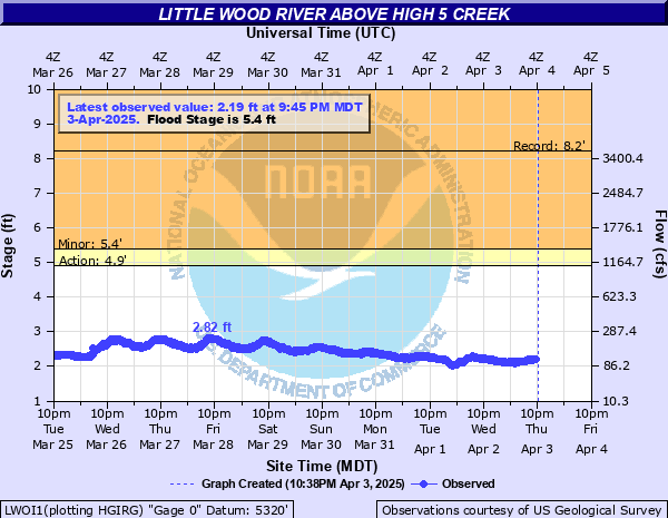
4.9' - Action
5.4' - Flood
Moderate
Major
Latest Observation
Updated: 6:45 AM MST 12/16/25
Status: No Flooding
Stage: 1.52 ft
Flow: 0.043 kcfs
Forecast
Forecast not available for this location.
| Time | Stage (ft) | Flow (kcfs) |
|---|---|---|
| 6:45 AM 12/16 | 1.52 | 0.043 |
| 6:30 AM 12/16 | 1.52 | 0.043 |
| 6:15 AM 12/16 | 1.52 | 0.043 |
| 6:00 AM 12/16 | 1.52 | 0.043 |
| 5:45 AM 12/16 | 1.52 | 0.043 |
| 5:30 AM 12/16 | 1.53 | 0.044 |
| 5:15 AM 12/16 | 1.52 | 0.043 |
| 5:00 AM 12/16 | 1.53 | 0.044 |
| 4:45 AM 12/16 | 1.53 | 0.044 |
| 4:30 AM 12/16 | 1.54 | 0.045 |
| 4:15 AM 12/16 | 1.54 | 0.045 |
| 4:00 AM 12/16 | 1.54 | 0.045 |
| 3:45 AM 12/16 | 1.54 | 0.045 |
| 3:30 AM 12/16 | 1.54 | 0.045 |
| 3:15 AM 12/16 | 1.54 | 0.045 |
| 3:00 AM 12/16 | 1.55 | 0.046 |
| 2:45 AM 12/16 | 1.55 | 0.046 |
| 2:30 AM 12/16 | 1.55 | 0.046 |
| 2:15 AM 12/16 | 1.55 | 0.046 |
| 2:00 AM 12/16 | 1.56 | 0.046 |
| 1:45 AM 12/16 | 1.56 | 0.046 |
| 1:30 AM 12/16 | 1.57 | 0.047 |
| 1:15 AM 12/16 | 1.56 | 0.046 |
| 1:00 AM 12/16 | 1.56 | 0.046 |
| 12:45 AM 12/16 | 1.57 | 0.047 |
| 12:30 AM 12/16 | 1.57 | 0.047 |
| 12:15 AM 12/16 | 1.58 | 0.048 |
| 12:00 AM 12/16 | 1.58 | 0.048 |
| 11:45 PM 12/15 | 1.58 | 0.048 |
| 11:30 PM 12/15 | 1.58 | 0.048 |
5.4' -
Minor flooding is possible above Little Wood Reservoir and up Muldoon Creek. Camping sites near the stream's edge may have water in them. Other creeks and streams in the area may experience minor flooding also.
4.9' -
Near bankfull above Little Wood Reservoir and up Muldoon Creek. Camping sites near the stream's edge may have water in them. Other creeks and streams in the area may be approaching bankfull.
| Date | Stage (ft) |
|---|---|
| Mar 22, 2018 | 8.22 |
| Apr 22, 1969 | 7.01 |
| May 19, 2005 | 7.01 |
| Apr 24, 1983 | 6.46 |
| Dec 23, 1964 | 6.2 |
| Apr 23, 2006 | 6.16 |
| Apr 9, 2019 | 6.03 |
| Apr 7, 2017 | 5.8 |
| May 25, 1967 | 5.71 |
| Apr 20, 1980 | 5.41 |
| Jun 5, 1995 | 5.4 |
| May 15, 1984 | 5.4 |
| May 8, 1971 | 5.39 |
| May 30, 1986 | 5.29 |
| Apr 19, 1962 | 5.14 |
| Jun 20, 2009 | 4.74 |
| Apr 17, 2011 | 4.58 |
| May 31, 2003 | 4.47 |
| Jun 13, 2022 | 4.46 |
| Apr 26, 2012 | 4.37 |
Data provided by the National Weather Service.