Chattahoochee River at West Point
Critical Stages
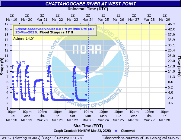
14' - Action
17' - Flood
19' - Moderate
21' - Major
Latest Observation
Updated: 11:00 AM EST 12/6/25
Status: No Flooding
Stage: 2.55 ft
Flow: 1.21 kcfs
Forecast
Forecast not available for this location.
| Time | Stage (ft) | Flow (kcfs) |
|---|---|---|
| 11:00 AM 12/6 | 2.55 | 1.21 |
| 10:45 AM 12/6 | 2.55 | 1.21 |
| 10:30 AM 12/6 | 2.55 | 1.21 |
| 10:15 AM 12/6 | 2.55 | 1.21 |
| 10:00 AM 12/6 | 2.55 | 1.21 |
| 9:45 AM 12/6 | 2.55 | 1.21 |
| 9:30 AM 12/6 | 2.55 | 1.21 |
| 9:15 AM 12/6 | 2.55 | 1.21 |
| 9:00 AM 12/6 | 2.55 | 1.21 |
| 8:45 AM 12/6 | 2.55 | 1.21 |
| 8:30 AM 12/6 | 2.55 | 1.21 |
| 8:15 AM 12/6 | 2.55 | 1.21 |
| 8:00 AM 12/6 | 2.56 | 1.22 |
| 7:45 AM 12/6 | 2.56 | 1.22 |
| 7:30 AM 12/6 | 2.56 | 1.22 |
| 7:15 AM 12/6 | 2.56 | 1.22 |
| 7:00 AM 12/6 | 2.56 | 1.22 |
| 6:45 AM 12/6 | 2.56 | 1.22 |
| 6:30 AM 12/6 | 2.56 | 1.22 |
| 6:15 AM 12/6 | 2.56 | 1.22 |
| 6:00 AM 12/6 | 2.56 | 1.22 |
| 5:45 AM 12/6 | 2.56 | 1.22 |
| 5:30 AM 12/6 | 2.56 | 1.22 |
| 5:15 AM 12/6 | 2.56 | 1.22 |
| 5:00 AM 12/6 | 2.56 | 1.22 |
| 4:45 AM 12/6 | 2.56 | 1.22 |
| 4:30 AM 12/6 | 2.56 | 1.22 |
| 4:15 AM 12/6 | 2.57 | 1.23 |
| 4:00 AM 12/6 | 2.57 | 1.23 |
| 3:45 AM 12/6 | 2.58 | 1.25 |
31.5' -
Waste Water Treatment Plant in West Point floods.
26' -
Major flooding occurs. Hundreds of homes and businesses flooded. Highway 29 on left bank...22 city blocks of West Point businesses flood...and 5 blocks of residences on left bank flood. One of the highest crests of modern times prior to West Point Dam was 24.9 feet on February 26...1961. Evacuations are required.
24.75' -
Major and extensive flooding occurs. Water reaches entrance to West Point Waste Water Treatment Plant.
24' -
Major to serious flooding occurs. Hundreds of businesses and homes in West Point as well as many streets in Lanett are flooded. Evacuations needed. Flood of Record...since the West Point Dam was built in the early 1970s...occurs. This post dam flood of record occurred on May 9th...2003...at 23.2 feet.
23' -
Major and extensive flooding occur. Expect 200 to 300 businesses and homes in West Point to be flooded out. Water enters into West Point Fire Headquarters. I-85 southbound will close as entrance and exit ramps flood. In Lanett...Highway 24 closes...with East 10th Street and Avenue C flooded. In addition...flooding spreads further into Lanett...with South Gilmer Avenue and 11th Street flooded. Evacuations required.
22' -
Major flooding in West Point and to a lesser extent in Lanett...as basements of 100 to 200 hundred businesses in West Point are flooded. Evacuations needed. In Lanett Alabama...South Gilmer Avenue and 1st Street flooded.
21' -
Major flooding begins. Parking lots of West Point City Hall...911 Center...Police Department...and Fire Department flooded out. Equipment needs to be moved. Evacuations need to begin.
20' -
Mainly low places on West Point City Streets are flooded.
19.5' -
Water enters West Point City Works Department. Equipment needs to be moved.
19' -
Moderate flooding begins. Mainly farm lands undergo some flooding. Flood waters enter parking lots near Fire House and 911 Center.
17' -
Minor flooding begins. City Hall...Police...and Fire Departments get some minor water into edge of parking lot.
14' -
Bankfull is reached in many locations especially on the Alabama side or right bank of the river downstream from the river gauge.
| Date | Stage (ft) |
|---|---|
| Dec 10, 1919 | 29.25 |
| Apr 1, 1886 | 25.6 |
| Mar 15, 1929 | 25.4 |
| Dec 30, 1901 | 25 |
| Feb 26, 1961 | 24.9 |
| Jan 19, 1925 | 24.6 |
| May 8, 2003 | 23.23 |
| Apr 8, 1936 | 22.9 |
| Mar 16, 1912 | 22.9 |
| Nov 29, 1948 | 22.4 |
| Jul 10, 1916 | 22.1 |
| Dec 30, 1932 | 21.7 |
| Mar 3, 1971 | 21.3 |
| Dec 23, 1918 | 21 |
| Jan 12, 1972 | 20.9 |
| Apr 25, 1945 | 20.4 |
| Mar 22, 1943 | 20.2 |
| Apr 9, 1938 | 20.2 |
| Mar 22, 1942 | 20.2 |
| Feb 9, 1903 | 20.1 |
Data provided by the National Weather Service.