« Back to Chula Vista Colonia Rivers
Frio River below Dry Frio near Uvalde
Critical Stages
10' - Action
12' - Flood
15' - Moderate
17' - Major
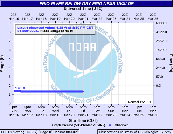
Latest Observation
Updated: 5:30 AM CST 12/16/25
Status: No Flooding
Stage: 1.42 ft
Flow: -999 kcfs
Forecast
Forecast not available for this location.
| Time | Stage (ft) | Flow (kcfs) |
|---|---|---|
| 5:30 AM 12/16 | 1.42 | -999 |
| 5:15 AM 12/16 | 1.42 | -999 |
| 5:00 AM 12/16 | 1.42 | -999 |
| 4:45 AM 12/16 | 1.42 | -999 |
| 4:30 AM 12/16 | 1.42 | -999 |
| 4:15 AM 12/16 | 1.42 | -999 |
| 4:00 AM 12/16 | 1.42 | -999 |
| 3:45 AM 12/16 | 1.42 | -999 |
| 3:30 AM 12/16 | 1.42 | -999 |
| 3:15 AM 12/16 | 1.42 | -999 |
| 3:00 AM 12/16 | 1.42 | -999 |
| 2:45 AM 12/16 | 1.42 | -999 |
| 2:30 AM 12/16 | 1.42 | -999 |
| 2:15 AM 12/16 | 1.42 | -999 |
| 2:00 AM 12/16 | 1.42 | -999 |
| 1:45 AM 12/16 | 1.42 | -999 |
| 1:30 AM 12/16 | 1.42 | -999 |
| 1:15 AM 12/16 | 1.42 | -999 |
| 1:00 AM 12/16 | 1.42 | -999 |
| 12:45 AM 12/16 | 1.42 | -999 |
| 12:30 AM 12/16 | 1.42 | -999 |
| 12:15 AM 12/16 | 1.42 | -999 |
| 12:00 AM 12/16 | 1.42 | -999 |
| 11:45 PM 12/15 | 1.42 | -999 |
| 11:30 PM 12/15 | 1.42 | -999 |
| 11:15 PM 12/15 | 1.42 | -999 |
| 11:00 PM 12/15 | 1.42 | -999 |
| 10:45 PM 12/15 | 1.42 | -999 |
| 10:30 PM 12/15 | 1.42 | -999 |
| 10:15 PM 12/15 | 1.42 | -999 |
17' -
Major flooding of crop and pastureland, traps livestock and can drown them. Secondary and primary roads and low bridges are flooded and dangerous.
15' -
Moderate flooding reaches crop and pasture land near the river. Secondary and primary roads and low bridges flood.
12' -
Minor lowland flooding reaches secondary and primary roads and low bridges.
10' -
Overbank conditions. No significant impact.
| Date | Stage (ft) |
|---|---|
| Jan 1, 1894 | 35 |
| Jul 1, 1932 | 30 |
| Jun 22, 1997 | 25.09 |
| Aug 13, 1966 | 23.88 |
| Dec 31, 1984 | 20.29 |
| Sep 21, 1995 | 17.81 |
| Sep 16, 1991 | 16.88 |
| May 24, 2015 | 15.48 |
| Jul 2, 2002 | 15.23 |
| Apr 23, 1981 | 14.52 |
| Oct 19, 1985 | 12.5 |
Data provided by the National Weather Service.