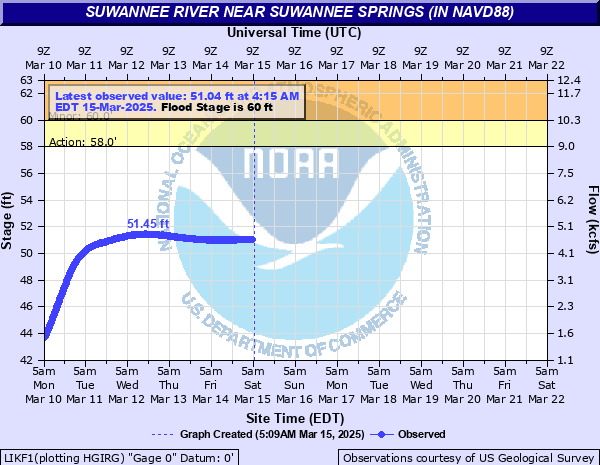
Suwannee River near Suwannee Springs (in NAVD88)
Critical Stages
58' - Action
60' - Flood
65' - Moderate
72' - Major
Latest Observation
Updated: 9:15 AM EST 12/14/25
Status: No Flooding
Stage: 37.92 ft
Flow: 0.214 kcfs
Forecast
Forecast not available for this location.
| Time | Stage (ft) | Flow (kcfs) |
|---|---|---|
| 10:15 AM 12/14 | 37.92 | 0.214 |
| 10:00 AM 12/14 | 37.93 | 0.215 |
| 9:45 AM 12/14 | 37.92 | 0.214 |
| 9:30 AM 12/14 | 37.92 | 0.214 |
| 9:15 AM 12/14 | 37.92 | 0.214 |
| 9:00 AM 12/14 | 37.91 | 0.212 |
| 8:45 AM 12/14 | 37.91 | 0.212 |
| 8:30 AM 12/14 | 37.92 | 0.214 |
| 8:15 AM 12/14 | 37.91 | 0.212 |
| 8:00 AM 12/14 | 37.91 | 0.212 |
| 7:45 AM 12/14 | 37.9 | 0.211 |
| 7:30 AM 12/14 | 37.91 | 0.212 |
| 7:15 AM 12/14 | 37.91 | 0.212 |
| 7:00 AM 12/14 | 37.9 | 0.211 |
| 6:45 AM 12/14 | 37.91 | 0.212 |
| 6:30 AM 12/14 | 37.91 | 0.212 |
| 6:15 AM 12/14 | 37.91 | 0.212 |
| 6:00 AM 12/14 | 37.91 | 0.212 |
| 5:45 AM 12/14 | 37.91 | 0.212 |
| 5:30 AM 12/14 | 37.91 | 0.212 |
| 5:15 AM 12/14 | 37.91 | 0.212 |
| 5:00 AM 12/14 | 37.91 | 0.212 |
| 4:45 AM 12/14 | 37.91 | 0.212 |
| 4:30 AM 12/14 | 37.9 | 0.211 |
| 4:15 AM 12/14 | 37.92 | 0.214 |
| 4:00 AM 12/14 | 37.9 | 0.211 |
| 3:45 AM 12/14 | 37.9 | 0.211 |
| 3:30 AM 12/14 | 37.92 | 0.214 |
| 3:15 AM 12/14 | 37.91 | 0.212 |
| 3:00 AM 12/14 | 37.91 | 0.212 |
85.4' -
Water reaches the top of the US 129 bridge railing.
82.6' -
Water begins to flood the US 129 bridge travel lanes.
79' -
Water approaches a few residences on Cecil Webb Place and Frink Place in Suwannee County.
78.2' -
Water reaches the base of the US 129 bridge. Water reaches the approach road surface to the US 129 bridge in Suwannee County about one quarter mile from the bridge.
76' -
The foot bridge (old US 129 bridge) across the Suwannee River floods at this level.
74' -
Portions of Spirit of the Suwannee Music Park begin to flood west of 95th Drive.
72' -
In Suwannee County water approaches RVs and mobile homes between the river at 95th Drive. Water begins to flood Cecil Webb Place near the boat ramp.
69' -
In Suwannee County, many areas between the river at 93rd Drive are flooded.
67' -
In Hamilton County, several residences are surrounded by water on SW 68th Drive. Structures not elevated are prone to flooding above this level. In Suwannee County, 91st Lane is impassible above this level.
66' -
In Suwannee County, water begins to surround homes of 91st Drive.
65' -
In Hamilton County, water begins to surround residences near SW 72nd Lane and Holton Creek. Structures not elevated are subject to flooding above this level.
64' -
Water begins to flood 91st Drive in Suwannee County.
63' -
In Hamilton County, much of SW 79th Terrace is flooded at this level. Access to homes in the area is restricted.
62' -
In Suwannee County, the entrance to the Suwannee Springs Park floods. Deese-Howard boat ramp is inaccessible.
60' -
Water comes over the bank at Suwannee Springs Park and begins to flood low lying areas of the park in Suwannee County. In Hamilton County, portions of SW 79th Terrace begin to flood.
| Date | Stage (ft) |
|---|---|
| Apr 12, 1973 | 78.2 |
| Apr 5, 1948 | 76.09 |
| Apr 10, 1984 | 73.67 |
| Sep 19, 1964 | 72.89 |
| Feb 28, 1998 | 71.43 |
| Mar 24, 1959 | 71.29 |
| Oct 6, 2004 | 70.59 |
| Jun 30, 2012 | 69.74 |
| Mar 20, 1984 | 69.21 |
| Feb 21, 1986 | 69.07 |
| Apr 29, 2014 | 68.56 |
| Dec 24, 2018 | 68.17 |
| May 11, 1964 | 67.98 |
| Mar 18, 1991 | 67.74 |
| Mar 22, 1966 | 67.43 |
| Sep 1, 1970 | 65.21 |
| Apr 10, 1970 | 65.08 |
| Mar 8, 1965 | 64.93 |
| Apr 26, 1975 | 64.86 |
| Feb 11, 1991 | 64.66 |
Data provided by the National Weather Service.