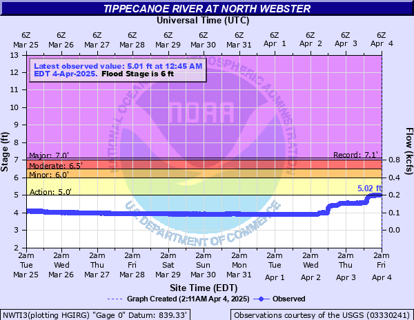
Tippecanoe River at North Webster
Critical Stages
5' - Action
6' - Flood
6.5' - Moderate
7' - Major
Latest Observation
Updated: 9:45 AM EST 12/14/25
Status: No Flooding
Stage: 3.2 ft
Flow: 0.017 kcfs
Forecast
Forecast not available for this location.
| Time | Stage (ft) | Flow (kcfs) |
|---|---|---|
| 9:45 AM 12/14 | 3.2 | 0.017 |
| 9:30 AM 12/14 | 3.22 | 0.0177 |
| 9:15 AM 12/14 | 3.21 | 0.0174 |
| 9:00 AM 12/14 | 3.2 | 0.017 |
| 8:45 AM 12/14 | 3.21 | 0.0174 |
| 8:30 AM 12/14 | 3.2 | 0.017 |
| 8:15 AM 12/14 | 3.2 | 0.017 |
| 8:00 AM 12/14 | 3.22 | 0.0177 |
| 7:45 AM 12/14 | 3.21 | 0.0174 |
| 7:30 AM 12/14 | 3.21 | 0.0174 |
| 7:15 AM 12/14 | 3.21 | 0.0174 |
| 7:00 AM 12/14 | 3.2 | 0.017 |
| 6:45 AM 12/14 | 3.21 | 0.0174 |
| 6:30 AM 12/14 | 3.21 | 0.0174 |
| 6:15 AM 12/14 | 3.21 | 0.0174 |
| 6:00 AM 12/14 | 3.2 | 0.017 |
| 5:45 AM 12/14 | 3.21 | 0.0174 |
| 5:30 AM 12/14 | 3.22 | 0.0177 |
| 5:15 AM 12/14 | 3.22 | 0.0177 |
| 5:00 AM 12/14 | 3.21 | 0.0174 |
| 4:45 AM 12/14 | 3.21 | 0.0174 |
| 4:30 AM 12/14 | 3.21 | 0.0174 |
| 4:15 AM 12/14 | 3.2 | 0.017 |
| 4:00 AM 12/14 | 3.2 | 0.017 |
| 3:45 AM 12/14 | 3.21 | 0.0174 |
| 3:30 AM 12/14 | 3.22 | 0.0177 |
| 3:15 AM 12/14 | 3.21 | 0.0174 |
| 3:00 AM 12/14 | 3.22 | 0.0177 |
| 2:45 AM 12/14 | 3.22 | 0.0177 |
| 2:30 AM 12/14 | 3.21 | 0.0174 |
7' -
Flood water begins to threaten home and store on the right bank of the river.
6.5' -
Water comes up into the store parking lot and into the yard of home on right bank of river near the river gauge.
6' -
Water begins to overflow right bank of the river near State Route 13 near a local store.
| Date | Stage (ft) |
|---|---|
| Feb 22, 2018 | 7.12 |
| Dec 5, 2011 | 6.84 |
| Mar 14, 2009 | 6.81 |
| Apr 21, 2013 | 6.55 |
| Jan 2, 1991 | 6.49 |
| Aug 22, 2001 | 6.22 |
| Jun 1, 2013 | 6.18 |
| Jan 10, 1993 | 6.17 |
| Jan 13, 2008 | 6.15 |
| May 20, 2020 | 6.04 |
| Jun 16, 2004 | 6 |
| Jan 15, 2005 | 5.98 |
| Feb 26, 1990 | 5.93 |
| Jan 11, 1998 | 5.81 |
| May 30, 2017 | 5.79 |
| Feb 27, 1997 | 5.77 |
| May 2, 2019 | 5.77 |
| May 14, 2002 | 5.76 |
| Jun 4, 1989 | 5.71 |
| Jun 18, 1996 | 5.67 |
Data provided by the National Weather Service.