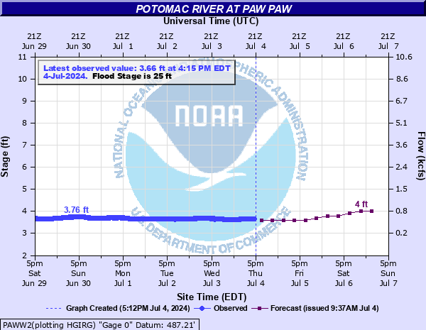
Potomac River at Paw Paw
Critical Stages
22.5' - Action
25' - Flood
30' - Moderate
37' - Major
Latest Observation
Updated: 4:15 PM EST 12/15/25
Status: No Flooding
Stage: 4.24 ft
Flow: 0.923 kcfs
Forecast
| Time | Stage (ft) | Flow (kcfs) |
|---|---|---|
| 7 PM 12/15 | 3.6 | 0.524 |
| 1 AM 12/16 | 3.7 | 0.582 |
| 7 AM 12/16 | 3.7 | 0.582 |
| 1 PM 12/16 | 3.7 | 0.582 |
| 7 PM 12/16 | 3.7 | 0.582 |
| 1 AM 12/17 | 3.7 | 0.582 |
| 7 AM 12/17 | 3.7 | 0.582 |
| 1 PM 12/17 | 3.7 | 0.582 |
| 7 PM 12/17 | 3.7 | 0.582 |
| 1 AM 12/18 | 3.7 | 0.582 |
| 7 AM 12/18 | 3.7 | 0.582 |
| Time | Stage (ft) | Flow (kcfs) |
|---|---|---|
| 4:15 PM 12/15 | 4.24 | 0.923 |
| 4:00 PM 12/15 | 4.24 | 0.923 |
| 3:45 PM 12/15 | 4.24 | 0.923 |
| 3:30 PM 12/15 | 4.25 | 0.93 |
| 3:15 PM 12/15 | 4.26 | 0.937 |
| 3:00 PM 12/15 | 4.27 | 0.944 |
| 2:45 PM 12/15 | 4.28 | 0.951 |
| 2:30 PM 12/15 | 4.29 | 0.958 |
| 2:15 PM 12/15 | 4.32 | 0.979 |
| 2:00 PM 12/15 | 4.33 | 0.986 |
| 1:45 PM 12/15 | 4.32 | 0.979 |
| 1:30 PM 12/15 | 4.34 | 0.993 |
| 1:15 PM 12/15 | 4.34 | 0.993 |
| 1:00 PM 12/15 | 4.36 | 1.01 |
| 12:45 PM 12/15 | 4.37 | 1.01 |
| 12:30 PM 12/15 | 4.39 | 1.03 |
| 12:15 PM 12/15 | 4.39 | 1.03 |
| 12:00 PM 12/15 | 4.41 | 1.04 |
| 11:45 AM 12/15 | 4.41 | 1.04 |
| 11:30 AM 12/15 | 4.41 | 1.04 |
| 11:15 AM 12/15 | 4.41 | 1.04 |
| 11:00 AM 12/15 | 4.43 | 1.06 |
| 10:45 AM 12/15 | 4.43 | 1.06 |
| 10:30 AM 12/15 | 4.44 | 1.06 |
| 10:15 AM 12/15 | 4.45 | 1.07 |
| 10:00 AM 12/15 | 4.43 | 1.06 |
| 9:45 AM 12/15 | 4.44 | 1.06 |
| 9:30 AM 12/15 | 4.41 | 1.04 |
| 9:15 AM 12/15 | 4.41 | 1.04 |
| 9:00 AM 12/15 | 4.4 | 1.04 |
62' -
Water covers the bridge over the Potomac at the state line in Paw Paw.
50' -
Homes in Paw Paw begin to flood.
46' -
Water approaches the intersection of West Virginia Route 9 and Winchester Street in Paw Paw.
40' -
The right bank of the river floods extensive sections of the town of Paw Paw, north of the B&O Railroad. The towpath of the C&O Canal also begins to flood.
37' -
Floodwaters cover both West Virginia Route 9 and Maryland Route 51. Businesses in the town of Paw Paw begin to flood.
34' -
Water reaches the settling pond next to Paw Paw Park.
30' -
Paw Paw Tunnel Campground begins to flood.
26' -
Water covers an access road on the West Virginia side.
25' -
A parking area adjacent to the highway bridge begins to flood. The roadway to the C&O Canal parking area floods, as does the lowest end of the Purslane Run hiker/biker area.
22.5' -
Water reaches the top of the boat ramp in Paw Paw Festival Park.
11' -
The river reaches danger level for boaters as defined by the State of Maryland. At danger level, conditions are considered extremely hazardous.
5' -
The river reaches caution level for boaters as defined by the State of Maryland. Fast moving water and current changes can be expected.
| Date | Stage (ft) |
|---|---|
| Mar 18, 1936 | 54 |
| Nov 5, 1985 | 53.58 |
| Jun 1, 1889 | 45 |
| Nov 24, 1877 | 45 |
| Mar 29, 1924 | 43.5 |
| Sep 7, 1996 | 43.45 |
| Jan 20, 1996 | 40.86 |
| Oct 16, 1942 | 38.36 |
| Aug 19, 1955 | 35.35 |
| Jun 19, 1949 | 33.91 |
| Oct 16, 1954 | 32.24 |
| Mar 20, 1963 | 31.48 |
| May 1, 1928 | 31.4 |
| Apr 17, 1993 | 30.62 |
| Oct 10, 1976 | 30.52 |
| Mar 8, 1967 | 30.24 |
| May 14, 2025 | 30.2 |
| Feb 26, 1979 | 29.13 |
| Jun 23, 1972 | 28.83 |
| May 19, 2011 | 28.67 |
Data provided by the National Weather Service.