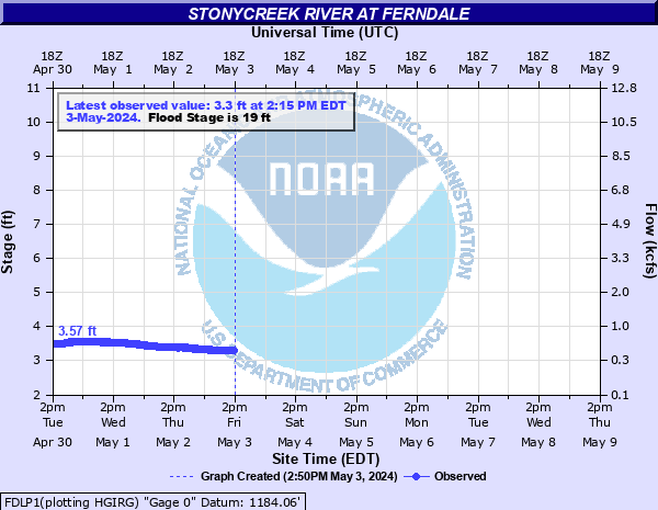
Stonycreek River at Ferndale
Critical Stages
15' - Action
19' - Flood
22' - Moderate
25' - Major
Latest Observation
Updated: 11:15 PM EST 12/17/25
Status: No Flooding
Stage: 2.64 ft
Flow: 0.181 kcfs
Forecast
Forecast not available for this location.
| Time | Stage (ft) | Flow (kcfs) |
|---|---|---|
| 11:15 PM 12/17 | 2.64 | 0.181 |
| 11:00 PM 12/17 | 2.64 | 0.181 |
| 10:45 PM 12/17 | 2.64 | 0.181 |
| 10:30 PM 12/17 | 2.63 | 0.177 |
| 10:15 PM 12/17 | 2.63 | 0.177 |
| 10:00 PM 12/17 | 2.63 | 0.177 |
| 9:45 PM 12/17 | 2.63 | 0.177 |
| 9:30 PM 12/17 | 2.63 | 0.177 |
| 9:15 PM 12/17 | 2.62 | 0.174 |
| 9:00 PM 12/17 | 2.63 | 0.177 |
| 8:45 PM 12/17 | 2.63 | 0.177 |
| 8:30 PM 12/17 | 2.62 | 0.174 |
| 8:15 PM 12/17 | 2.62 | 0.174 |
| 8:00 PM 12/17 | 2.63 | 0.177 |
| 7:45 PM 12/17 | 2.63 | 0.177 |
| 7:30 PM 12/17 | 2.63 | 0.177 |
| 7:15 PM 12/17 | 2.62 | 0.174 |
| 7:00 PM 12/17 | 2.62 | 0.174 |
| 6:45 PM 12/17 | 2.62 | 0.174 |
| 6:30 PM 12/17 | 2.62 | 0.174 |
| 6:15 PM 12/17 | 2.62 | 0.174 |
| 6:00 PM 12/17 | 2.62 | 0.174 |
| 5:45 PM 12/17 | 2.62 | 0.174 |
| 5:30 PM 12/17 | 2.61 | 0.17 |
| 5:15 PM 12/17 | 2.61 | 0.17 |
| 5:00 PM 12/17 | 2.61 | 0.17 |
| 4:45 PM 12/17 | 2.61 | 0.17 |
| 4:30 PM 12/17 | 2.62 | 0.174 |
| 4:15 PM 12/17 | 2.62 | 0.174 |
| 4:00 PM 12/17 | 2.62 | 0.174 |
35' -
Flood waters begin to reach the Washington Street Bridge.
33' -
Flood waters begin to reach the Franklin Street Bridge.
32' -
FEMA 0.2 0X0P+0nnual Chance Flood Level (500-year flood).
26' -
Flood waters begin to reach the Moxham Bridge.
25' -
Flood waters begin to reach the Horner Street Bridge.
23.2' -
Flood of record from July, 1977.
22.5' -
FEMA 1 0X0P+0nnual Chance Flood Level (100-year flood). Flood waters begin to reach the Roosevelt Boulevard Bridge. High water overflows both banks.
22' -
Flood waters begin to reach the Hickory Street Bridge.
21' -
High water overflows both banks.
20.5' -
Flood waters begin to reach the Bridge Street Bridge. High water overflows both banks.
19.5' -
FEMA 2 0X0P+0nnual Chance Flood Level (50-year flood). Flood waters begin to reach the Eisenhower Boulevard Bridge.
19' -
High water begins to overflow the right bank.
16.5' -
Flood waters begin to reach the King Street Bridge.
14.5' -
FEMA 10 0X0P+0nnual Chance Flood Level (10-year flood).
| Date | Stage (ft) |
|---|---|
| Jul 20, 1977 | 23.21 |
| Jan 19, 1996 | 17.809999465942 |
| Jun 23, 1972 | 13.36 |
| Apr 17, 1993 | 10.4 |
Data provided by the National Weather Service.